
Dangerous wind direction today for Victoria
The combination of rain-soaked soil and strong winds coming from an usual direction will create a dangerous mix of weather in parts of Victoria today.
As Australia's southern-most mainland state, Victoria is no stranger to powerful winds and heavy rain. Most of this wind and rain is usually produced by from cold fronts or low pressure systems that come barreling out of the Southern Ocean. These systems typically hit Victoria with wind coming from the west or south.
However on Friday, a different kind of weather system will impact Victoria and its unusual wind direction will increase the risk of damage in some parts of the state.
A low pressure system entering Victoria from the north will cause a strengthening flow of east to southeastern winds across the state on Friday. These winds will be accompanied by widespread rain and some thunderstorms, which will be fuelled by moisture-laden air from the tropics.

Image: Synoptic chart showing a low pressure system near northeast Victoria on Friday morning. View the latest Australia synoptic charts here.
The landscape in Victoria, including the vegetation and infrastructure on it, is accustomed to winds coming from the west and south. However, today's winds flowing in from the east and southeast have the potential to cause damage in areas that are typically well-protected.
🚨ALERT: Tomorrow's combination of an unusual south-easterly wind direction and also wet conditions on the ground do mean that damage to trees is more likely, leading to potential power outages. We’re asking customers to take precautions now. https://t.co/I3dbBKpunq pic.twitter.com/ij8XibJEbw
— Powercor Australia (@PowercorAust) November 11, 2021
The strongest winds on Friday will occur on the ranges to the north and northwest of Melbourne, where a severe weather warning is in place for gusts above 90km/h in the middle of the day and the afternoon.
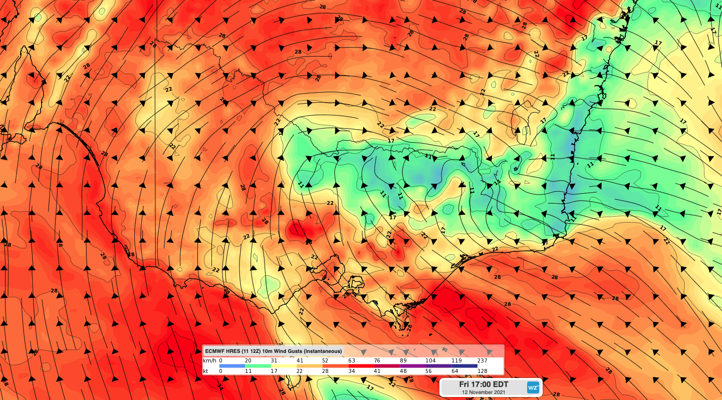
Image: Forecast wind gust speed and direction on Friday afternoon, according to the ECMWF-HRES model.
Blustery winds will also accompany heavy rain in parts of eastern Victoria, where another warning is in place for heavy rain and flooding in the East Gippsland, West and South Gippsland and parts of North East Forecast Districts.

Image: Forecast accumulated 48-hour rainfall on Friday and Saturday, according to the ECMWF-HRES model.
Victoria had a taste of how dangerous rain-bearing southeasterly winds can be earlier this year, when a large number of trees were brought down in the Dandenong Ranges back in mid-June.
While this week's wind shouldn't be as strong as that event, communities in central, southern and eastern Victoria should closely monitor the latest warnings in their area throughout the day.