
Dangerous heavy rain in inland NSW, parts of Vic
An intense band of rain and thunderstorms swept across New South Wales and some northern parts of Victlria overnight, with heavy rain continuing on Thursday morning, accompanied by strong winds.
IN NSW: A Severe Weather Warning for damaging winds and heavy rainfall was issued by the Bureau of Meteorology overnight for people in the: Illawarra, Southern Tablelands, South Coast, Central Tablelands, North West Slopes and Plains, Central West Slopes and Plains, South West Slopes, Snowy Mountains, ACT, Sydney Metropolitan, Riverina, and parts of the Hunter, Forecast Districts.
IN VIC: A Severe Weather Warning for heavy rainfall is in place for people in: parts of East Gippsland and North East Forecast Districts.
It's not often that rain originating from the west is as heavy over several hours than rain that comes in off the Tasman Sea on an easterly wind flow, in the sort of weather we've all seen in coastal flood events this year.
But that's exactly what's happening today.
The rain
The BoM says that six-hourly rainfall totals between 45 and 60 mm are expected in the Snowy Mts and South West Slopes forecast districts, with localised falls up to 100 mm possible with embedded shower and thunderstorm activity.
- Overnight, the ski villages of Perisher and Thredbo both recorded more than 60 mm (of rain, not snow as this is a relatively warm system for winter) to 9 am.
- To illustrate how fast the rain is accumulating, they’d both received 9.8 mm in the gauge by 10:00 am. This is a tropical downpour type rain accumulation rate, and naturally, it's a bit of a disaster for the snowpack.
- Rainfall has also been heavy in the ACT, with 23.4 mm in the national capital to 9 am, another 7.2 mm by 10 am, and steady rain looking set in for the rest of today.
The wind
Extreme winds have been recorded in numerous locations, including:
- A gust of 100 km/h at Khancoban, on the Upper Murray River on the western flank of the Snowy Mountains.
- Storms also brought 90km/h gusts to White Cliffs, in the state's far northwest, around midnight.
The warmth
As just one example which shows that there is a lot of warm air around with this system, Sydney yesterday had a maximum around 25°C in many suburbs, its hottest day this winter by far.
With so much warm air and cloud cover around, high minimum temperatures for winter were recorded across the whole of NSW overnight.
- Wilcannia only got down to 16.1°C, its warmest Aug min since 2005,
- Khancoban only dropped to 10.3°C, the warmest Aug night since 2007.
- Sydney (Observatory Hill) had an official low of 15.4°C, the warmest Aug night since 2015.
- Sydney Airport had a very balmy minimum of 15.7°C, its warmest Aug night since 2009
- Cooma's low of 8.0°C was its warmest Aug night since 2009, and remarkable as it registered an overnight low of -10°C on the weekend.
This is an ongoing dangerous weather situation today. We wrote yesterday that flooding rain, thunderstorms and dangerous winds will spread over southern and southeastern Australia during the next two days, and so it has proven.
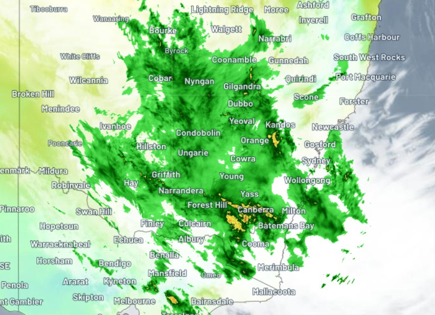
It's actually worth comparing the rain map we published yesterday with Thursday morning's radar image taken just after 9 am.
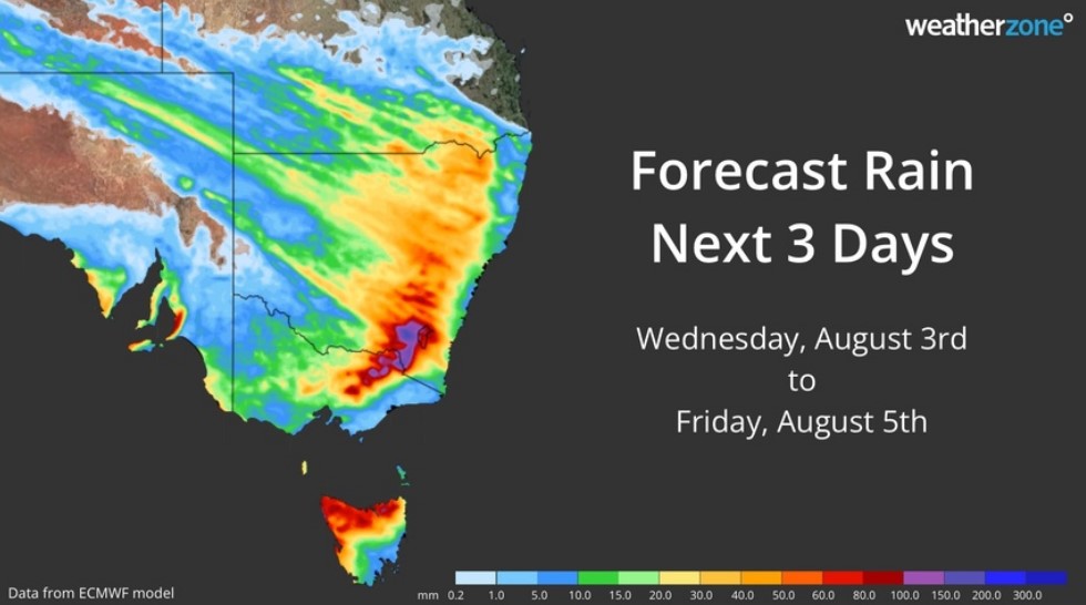
As you can see, the area of heavy rainfall is pretty much right on target in the ACT Snowy Mountains and SW Slopes districts, as predicted, as well as small parts of NE and eastern Vic.
We'll keep you updated today as this serious weather situations evolves, and please check our warnings page here.