
Countdown to Christmas amidst severe thunderstorm outbreak in Eastern Australia
Today, Eastern Australia is experiencing a significant thunderstorm outbreak, prompting severe thunderstorm warnings for eastern and southeast Queensland, eastern New South Wales, including the Sydney Metropolitan area, and parts of western Victoria.
The most intense storms are unfolding in southeast Queensland, where heavy rainfall, large-to-giant hailstones, and damaging wind gusts are developing. From 9 am to 3 pm EST, a total of 211,384 strikes (comprising ground and cloud events) have been recorded within 200 km of Brisbane, including 48,281 lightning strikes hitting the ground (image).
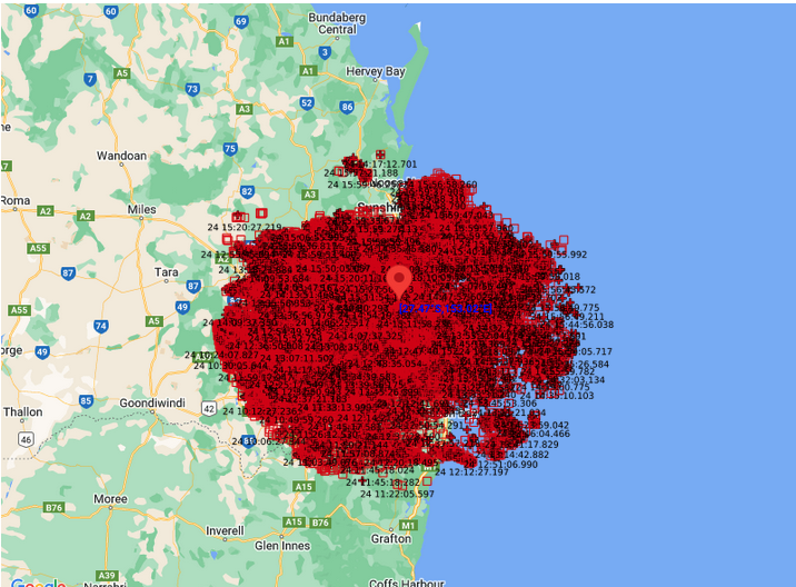
Image: Lightning strikes recorded within 200 km of Brisbane (211,384 strikes including ground and cloud events) from 9 am to 3 pm EST.
Notably, Dayboro and Burpengary reported giant hailstones, measuring an impressive 8 cm and 9 cm, respectively. Recent observations in Burpengary raise the stakes, suggesting that hailstones may have reached an even more impressive 15 or 16 cm. If confirmed, this could potentially equal the Australian record set in Yalboroo near Mackay in October 2021, which measured 16 cm.
Intense rainfall has also accompanied these thunderstorms in southeast Queensland, with precipitation rates exceeding 30 mm in half an hour and including an impressive 22.4mm in 10 minutes at Gatton. Key totals include :
- 30 mm at Gambubal in 30 minutes to 10:30 am.
- 35 mm at Sandy Creek Road in 30 minutes to 10:45 am.
- 58 mm in 30 minutes at Wivenhoe Dam.
Furthermore, from 9 am to 03:25 pm EST, notable rainfall figures include:
- 45 mm at Gatton (the highest December rain in 2 years).
- 35.1 mm in Aratula (the highest December rain in 3 years).
- 35.6 mm in Gold Coast Seaway (also the highest December rain in 2 years).
Severe thunderstorms are anticipated to persist in the Brisbane area until mid-evening.
In the Sydney area, severe thunderstorms with heavy rainfall were recorded this morning and early afternoon. Significant rainfall from 9 am to 3 pm EDT includes:
- 29.2 mm at Sydney Olympic Park (the highest December rainfall in 8 years).
- 32 mm in Canterbury (the highest December rain in 5 years).
- 17.6 mm at Sydney Observatory Hill.
- The most substantial precipitation occurred during the late morning and early afternoon with thunderstorms at Koolewong, recording 55 mm in the 60 minutes to 12:30 pm.
Looking forward, brace for continued scattered to widespread severe thunderstorm activity across Queensland, New South Wales, and Victoria until at least Boxing Day. This prolonged weather activity is shaped by a deepening trough supported in the upper levels by an upper low and strong jet stream. These conditions are likely to produce localised heavy rainfall, large-to-giant hail, and damaging-to-destructive winds over the coming two days, including Canberra, Sydney, Brisbane and Melbourne.
Keep an eye on the latest severe thunderstorm warnings for the most up-to-date information as storms develop over the next few days.