Could we see a third consecutive La Nina?
A highly regarded international long-range forecast model is hinting at the possibility of a third consecutive La Niña event later this year. But before getting too worried about the prospect of a triple-dip La Niña, there are a few reasons why this outlook should be taken with a grain of salt for now.
First up, what is La Niña?
La Niña is a pattern of ocean temperature and wind anomalies across the Pacific Ocean, which affects weather patterns around the world.
During La Niña, which occurs about 1-2 times per decade on average, large areas of northern, central and eastern Australia typically see above average rain. La Niña also promotes cooler days and warmer nights in some parts of Australia. The map below shows some of the typical changes in global rainfall patterns during La Niña.
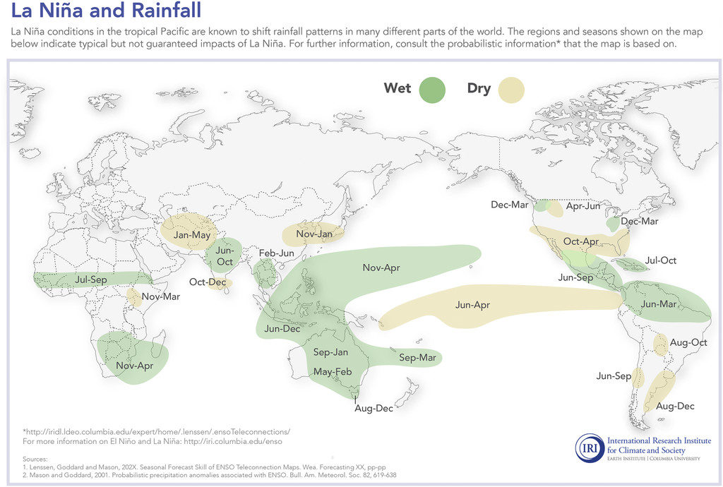
Image: Typical global rainfall response to La Niña. Source: IRI / Columbia University
Already two in the bag
The Pacific Ocean has been in a La Niña phase during the last two Southern Hemisphere summers. The first occurred between late-September 2020 and March 2021. This was followed by the current La Niña, which commenced in November 2021 and is still underway.
While the current La Niña started to weaken from January, it has regained some strength in the last couple of weeks due to abrupt cooling of the central equatorial Pacific Ocean. This restrengthening of La Niña coincided with record-breaking rain and widespread flooding in eastern Australia during late-February and early March.
Following the recent cooling in the central equatorial Pacific, La Niña is expected to last until late-autumn before most likely breaking down by winter. This will increase the likelihood of above-average rain in northern and eastern Australia during the next few months.
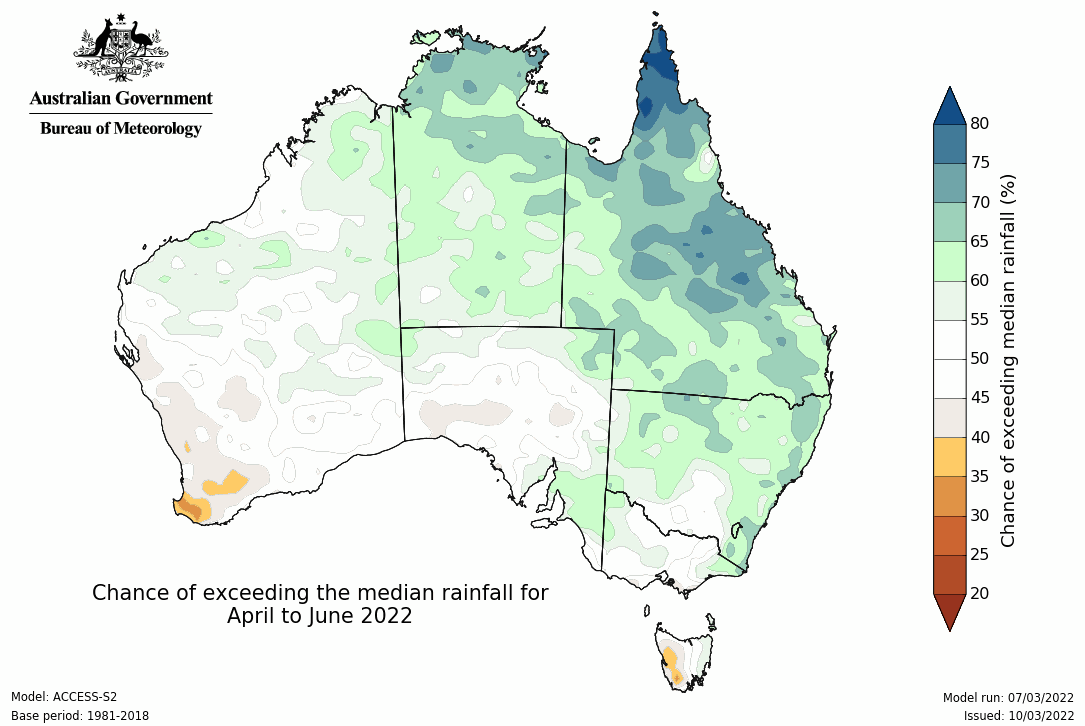
Image: ACCESS-S2 chance of exceeding median rainfall for April to June 2022. Source: BOM
Is it possible to have three in a row?
It is not uncommon to see La Niña occuring over two consecutive seasons. This happened in both 2020-22 and 2010-12. However, it is very rare to see three consecutive La Niña events.
The graph below shows the evolution of the eight most recent double-dip La Niña events, including the past two years (black line), based on sea surface temperatures in the central equatorial Pacific Ocean. Note that this graphic is based on the Northern Hemisphere dates, so January is labelled as winter.
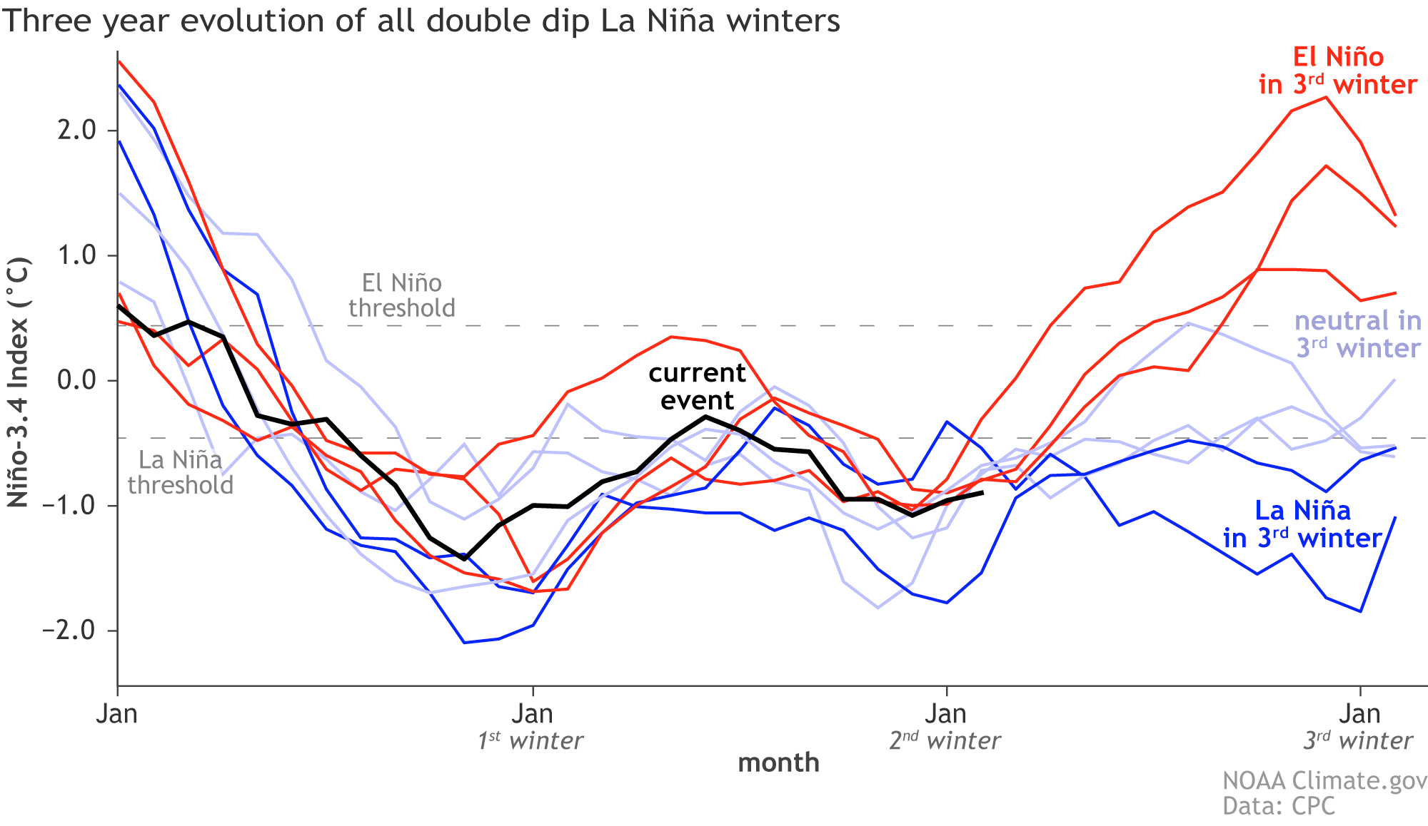
Image: Sea surface temperature anomalies in the NINO-3.4 region of the Pacific Ocean during the eight most recent double-dip La Niña events, including what happened in the following (third) year. Source: NOAA CPC
The graph above shows that only two of the last eight double-dip La Niña events went on to include a third consecutive La Niña in the following season. Of the remaining six lines in this time series, three were neutral in the third year and three went on to El Niño in the third year.
It’s worth pointing out that during the two triple-dip La Niña events, the blue line remains close to or within La Niña thresholds between the second and third years. This implies that a La Niña which fails to properly break down after the second season has a better chance of re-emerging for a third season.
What lies ahead?
There is good agreement between global forecast models that La Niña will weaken in the next few months. This fits with the typical lifecycle of La Niña events, which usually decay from late-summer and end around autumn.
Looking further ahead, most forecast models predict the Pacific Ocean will be in a neutral state during the Southern Hemisphere's winter. This means neither La Niña or El Niño are occurring in the Pacific.
However, a seasonal forecast model operated by the U.S. National Weather Service’s Climate Prediction Centre (CPC) suggests that a La Niña-like signal could linger in the Pacific Ocean through the middle of the year and possibly remerge in the Southern Hemisphere’s spring.
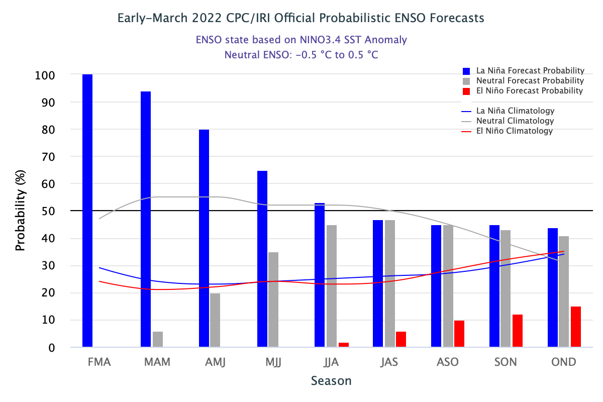
Image: El Niño-Southern Oscillation (ENSO) forecast for the next 10 months, according to the U.S. CPC/IRI. The blue bars show the probability of La Niña occurring during each three-month period, with grey and red bars representing the probability of neutral and El Niño, respectively. Source: CPC/IRI
The map above shows that there is a 44% chance of La Nina, 41% chance of neutral conditions and a 15% chance of El Nino between October, November and December.
However, most other international seasonal forecast models are currently favouring neutral conditions during the Southern Hemisphere’s winter and spring.
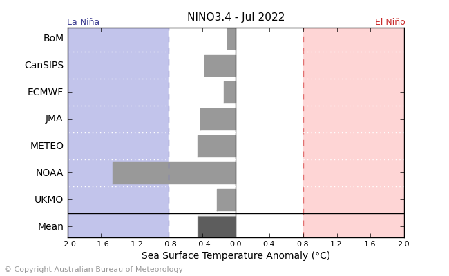
Image: Comparison of international seasonal forecast model’s predictions of central equatorial Pacific Ocean temperatures in July 2022. This graph shows that only the U.S. model is predicting La Niña in the middle of this year. Source: Bureau of Meteorology
It is important to note that ENSO seasonal forecast models have lower accuracy at this time of year. This is called the autumn predictability barrier (or spring predictability barrier in the Northern Hemisphere). With this in mind, the forecasts discussed above should be treated as early signals rather than discreet forecasts. Models will start to have more reliability as we enter winter in the Southern Hemisphere.
At this stage, the most likely state of the Pacific Ocean towards the end of this year will be either neutral or La Niña, with El Niño currently unlikely. Weatherzone will be closely monitoring this situation and giving more updates during the coming months.