
Could the remnants of Tropical Cyclone Seroja affect Perth?
Tropical Cyclone Seroja is going to stay away from the Australian mainland during the next few days. But what happens towards the end of this week is harder to predict thanks to the prospect of the Fujiwhara effect.
Seroja became a tropical cyclone near Kupang in Indonesia on Monday morning. Since then the system has drifted south and gained strength.
At 8am AWST on Tuesday, Seroja was a category two tropical cyclone located between Australia and Indonesia, about 770 km to the north northwest of Broome.
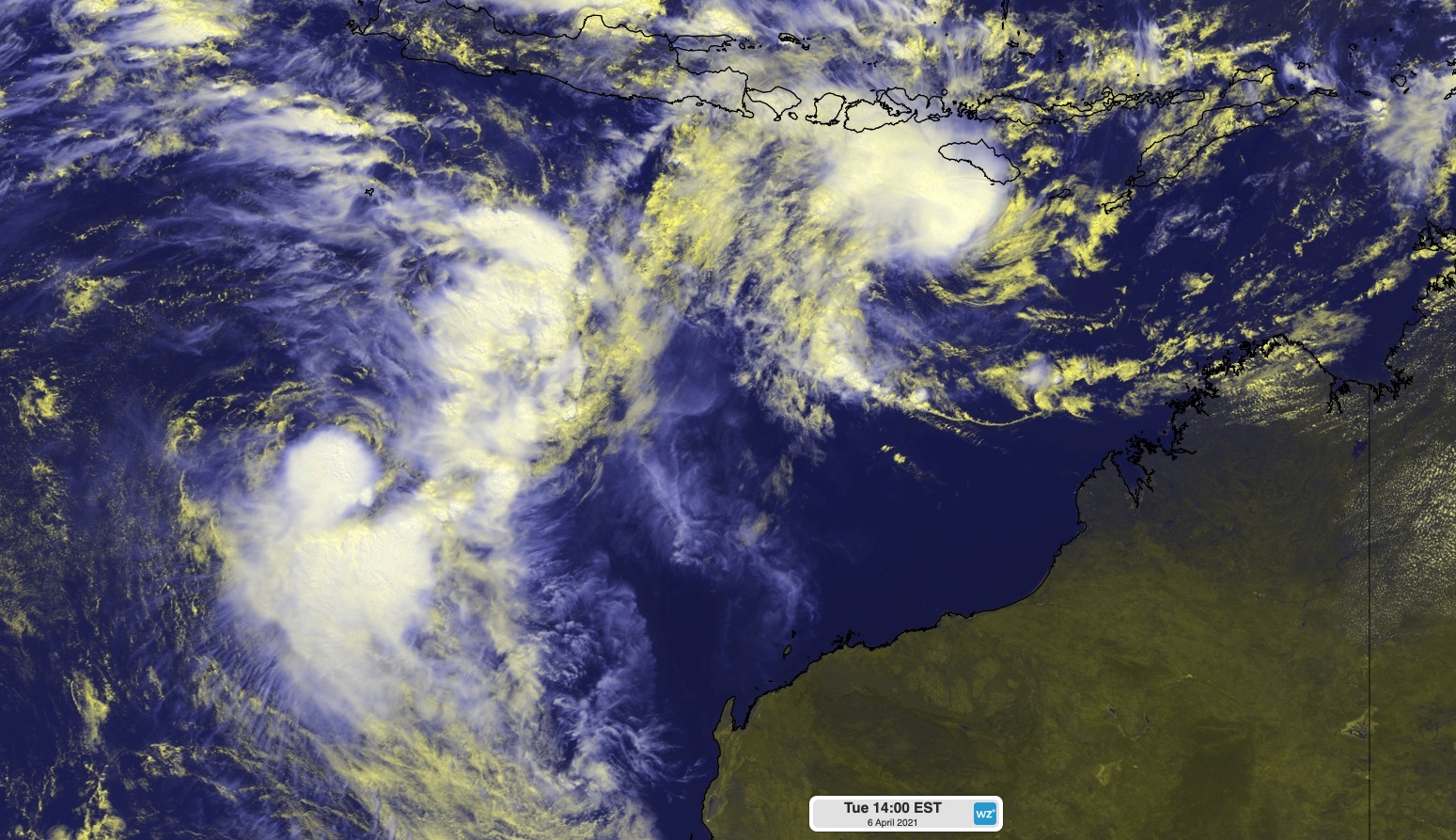
Image: Enhanced visible satellite image of Tropical Cyclone Seroja (top right) and a Tropical Low (left) on Tuesday.
Forecast models agree that Cyclone Seroja will gradually gain strength as it moves towards the west southwest between Tuesday and Thursday. This path will be roughly parallel to Western Australia's northern coastline, which will help keep Seroja's severe weather well away from the Australian mainland during that time.
However, the movement of Tropical Cyclone Seroja beyond Thursday is going to be complicated by another tropical low pressure system.
This tropical low was located about 670 km to the south of Christmas Island at 8am AWST on Tuesday. It should remain slow-moving in this region on Tuesday and Wednesday, before possibly interacting with approaching Tropical Cyclone Seroja from Thursday or Friday.
When two cyclonic circulations come into close proximity, they begin a 'dance' that causes both vortices to rotate around a common central point. This interaction is called the Fujiwhara effect, named after Japanses meteorologist Sakuhei Fujiwhara who documented it in the 1920's.
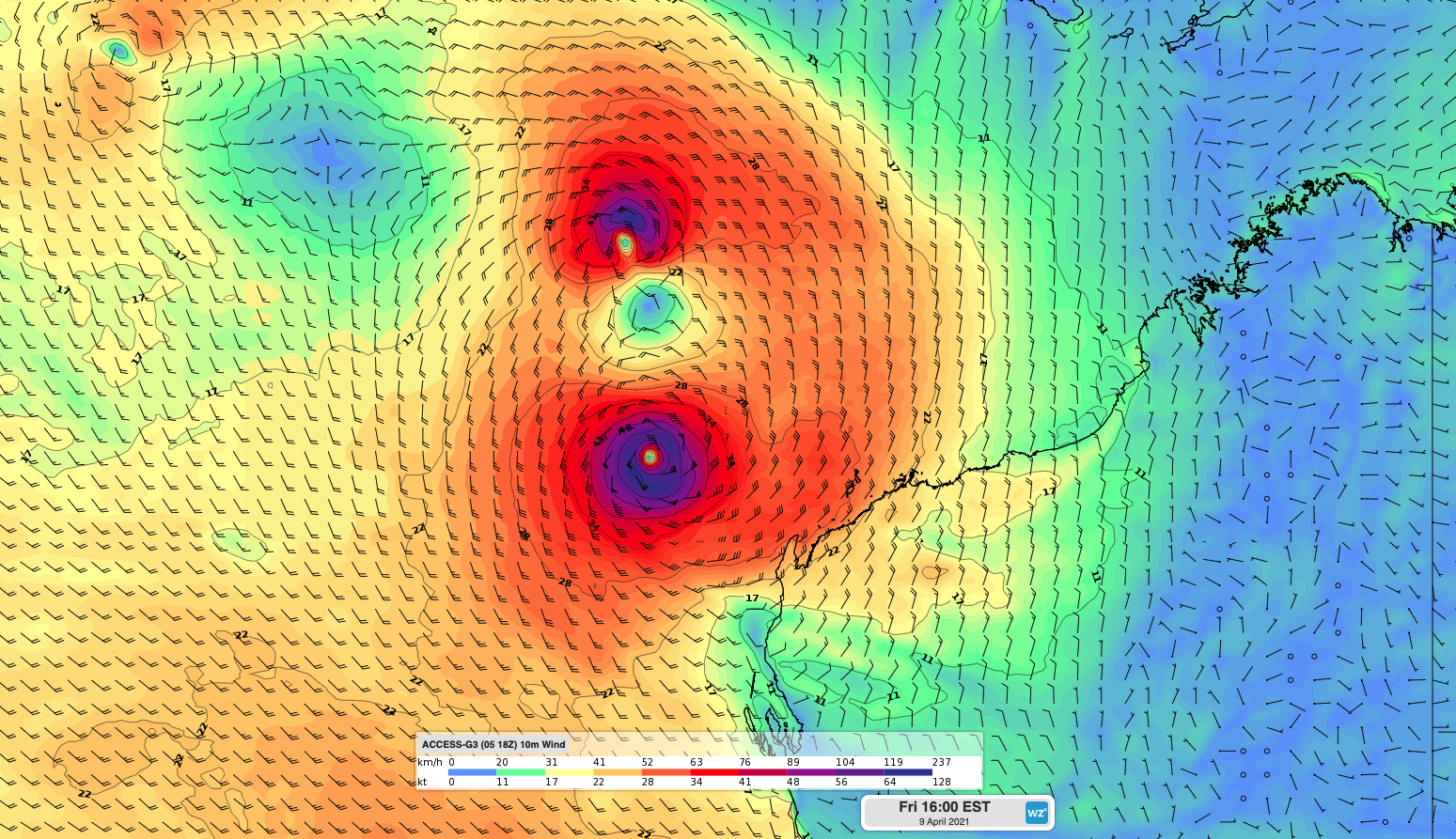
Image: Forecast surface wind speed and direction on Friday according to the ACCESS-G model, showing the interaction between Tropical Cyclone Seroja and a Tropical Low near Western Australia.
Unfortunately, the Fujiwhara effect makes it extremely difficult to predict a tropical cyclone's future movement. It can change both the path and strength of each cyclone and, under the right conditions, the stronger cyclone can absorb the weaker one.
For Tropical Cyclone Seroja and the other tropical low, there are a broad range of possible future scenarios beyond Thursday.
Some models suggest that the amalgamated system, comprising both cyclones, will move south and cause an increase in wind, rain and thunderstorms over northwestern districts of Western Australia from Friday into the weekend.
There are even indications that a remnant low pressure system will drift further south from Sunday or early next week, possibly causing severe weather along the state's west coast. This could include Perth and other areas of the Central/Lower West Coast.
It's too early to know if and how the Fujiwhara effect will influence these tropical systems. But anyone living in western or northwestern districts of Western Australia should keep a close eye on the latest track maps and warnings over the coming week.
If another tropical cyclone develops inside Australia’s area of responsibility, it will be named Odette.