
Coldest May day in almost 50 years for parts of Queensland
Queensland was gripped by an unseasonably chilly day on the second to last day of May, with Gladstone recording its coldest May day in nearly 50 years, marking a rare late-autumn chill for the coastal city. Friday's cold conditions were driven by a coastal trough, reinforced by a pool of cold air in the upper atmosphere. This setup produced widespread cloud cover with frequent rain and showers across broad areas of eastern and southern Queensland, which are persisting into today, the final day of May.
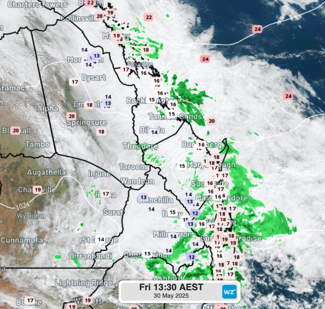
Image. Observed temperatures at 1:30 pm EST on Friday 30th across parts of eastern and southeastern Qld and northeast NSW.
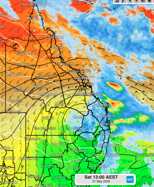
Image. Temperature (shaded), wind (barbs), and geopotential height (black contours) at 500 hPa—approximately 5.5 km above the surface—highlighting the pool of cold mid-level air, along with forecast 6-hour accumulated rainfall totals to 1 pm EST Saturday across Queensland and parts of northeast NSW.
The cold standout was Gladstone, where the temperature only managed to climb to 16.3°C just after 4 pm—nearly 10°C below the May average. This made it the coldest May day since 12th May 1978, when the maximum reached just 13.8°C, and marks 47 years since the city has been this cold in May.
Several locations across eastern and southeastern Queensland also recorded their coldest May day in between 1 and 5 years, with maximum temperatures ranging from the low teens to low 20s (falling 6 to 12°C below the May average). Even Brisbane joined in the chill, only reaching 18.9°C—its coldest May day in three years, and nearly 6°C below the monthly average.
The coldest maximum temperatures recorded on Friday 30th May included:
Coldest May day in 5 years:
- Miles: 14.0°C – nearly 10°C below average
- Kingaroy: 14.3°C – nearly 8°C below average
- Warwick: 14.4°C – around 7°C below average
- Biloela: 14.5°C – roughly 12°C below average
- Moranbah Airport: 14.7°C – approximately 12°C below average
Coldest May day in 3 years:
- Toowoomba: 14.3°C – about 6°C below average
The system responsible for the cold has been delivering rainfall to eastern Queensland and northeast New South Wales since Thursday 29th May. Significant rainfall totals recorded in the 24 hours to 9 am Saturday include:
- Yamba (NSW): 69.6 mm
- Evans Head (NSW): 51.8 mm – heaviest May rain in 5 years
- Coolangatta Airport: 48.2 mm
- Ballina (NSW): 43.2 mm
- Cape Byron (NSW): 38.2 mm
- Gold Coast Seaway (Qd): 31.6 mm
- Brisbane (Qld): 5.2 mm
- Widespread rainfall totals of 20–30 mm were reported at multiple locations across southeast Qld and northeast NSW.
What’s next?
The coastal trough and upper-level disturbance are expected to maintain areas of heavy rain across southeast Qld and northeast NSW into Sunday morning. The entire system will gradually move east, bringing relatively drier conditions to these regions. However, some showers may linger throughout the remainder of Sunday, ahead of another system that is forecast to bring areas of heavy rain on Monday.
Stay informed by checking our webpage for the most recent forecast here.