
Burst of severe weather over southeast on Sunday
A low pressure system will rapidly amplify over Victoria and nearby regions on Sunday, bringing heavy rain, strong winds and storms.
Southern Australia continues to be dominated by a trough that divides hot air to the north and cooler air to the south. When a low drifting in from the Australian Bight reaches this unstable zone on Sunday, it will quickly intensify.
Rain and storms over northwest Vic and adjacent SA Sunday morning will spread east during the afternoon and become heavy. Eastern Victoria and adjacent NSW is also where the strongest winds will occur. Gales with gusts over 120km/h are expected for parts of the southeast coast and the alpine areas before the low moves out over the Tasman Sea. Gusts over 90km/h are also possible for the NSW tablelands further north as the low forces powerful westerly winds over the ranges.
Rainfall totals will peak over near alpine areas with widespread 12-hr falls of 30-60mm and some isolated falls of near 100mm, mostly falling in around 6 hours during Sunday afternoon. Further afield, widespread 24-hr rain of 20-30mm is expected across large areas of Victoria and the southwestern inland half of NSW as the low helps brew storms and rain near the lingering trough. Similar totals are also possible for northeast Tasmania as the low grazes the region on its way past.
Once the low moves away early Monday morning, the blustery weather will not be over for southern parts, with a series of cold fronts bringing gusty showers to southern Victoria and Tasmania on Tuesday and Wednesday. The cold air with these fronts will lower the snow level, especially over the Apple Isle. While the initial air behind the low on Sunday night/Monday morning will only be cool enough to bring the odd snow shower above about 1700-1800m, by Tuesday morning the snow level will have lowered to 1000m over Tasmania: a white Christmas Eve for those up high.
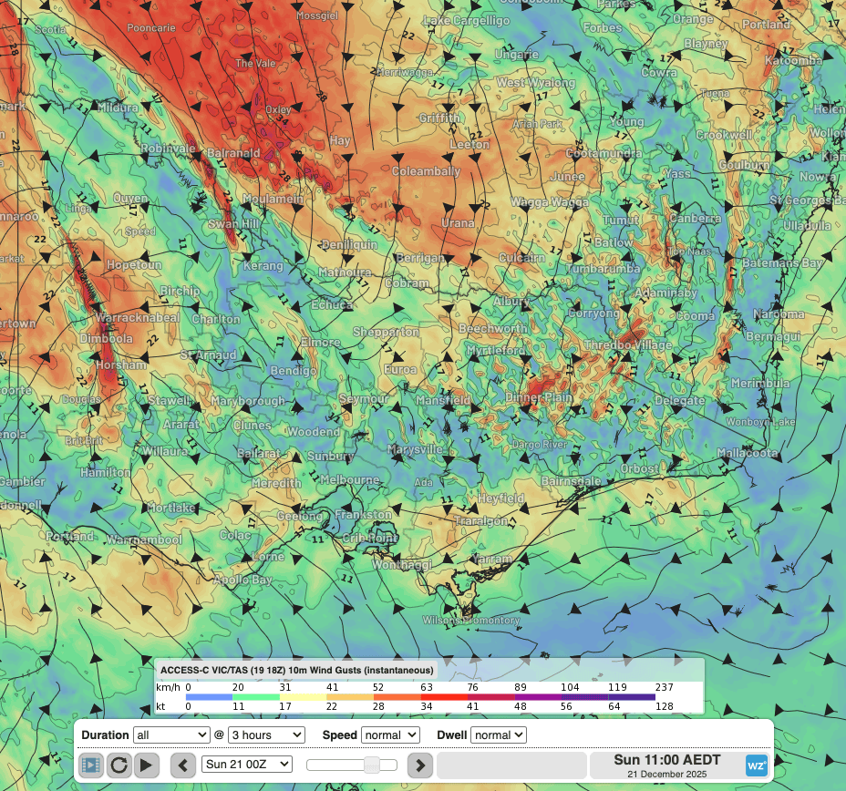 Image: Forecast 10-m wind gust animation from Sunday morning to evening, according to Access-C Victoria/Tasmania. Source: Weatherzone.
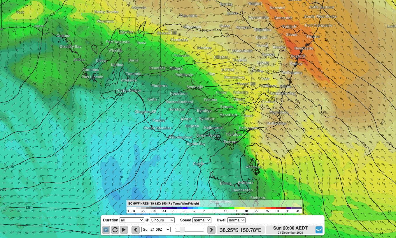
Image: Forecast temperature and wind at around 5000ft above the surface, showing the hot-cold north-south divide and strong winds near the low. Wind at this level is often a good proxy for surface wind gust strength outside alpine areas and shows greater than 50 knots (90km/h) over parts of eastern Vic and NSW. Source: Weatherzone.
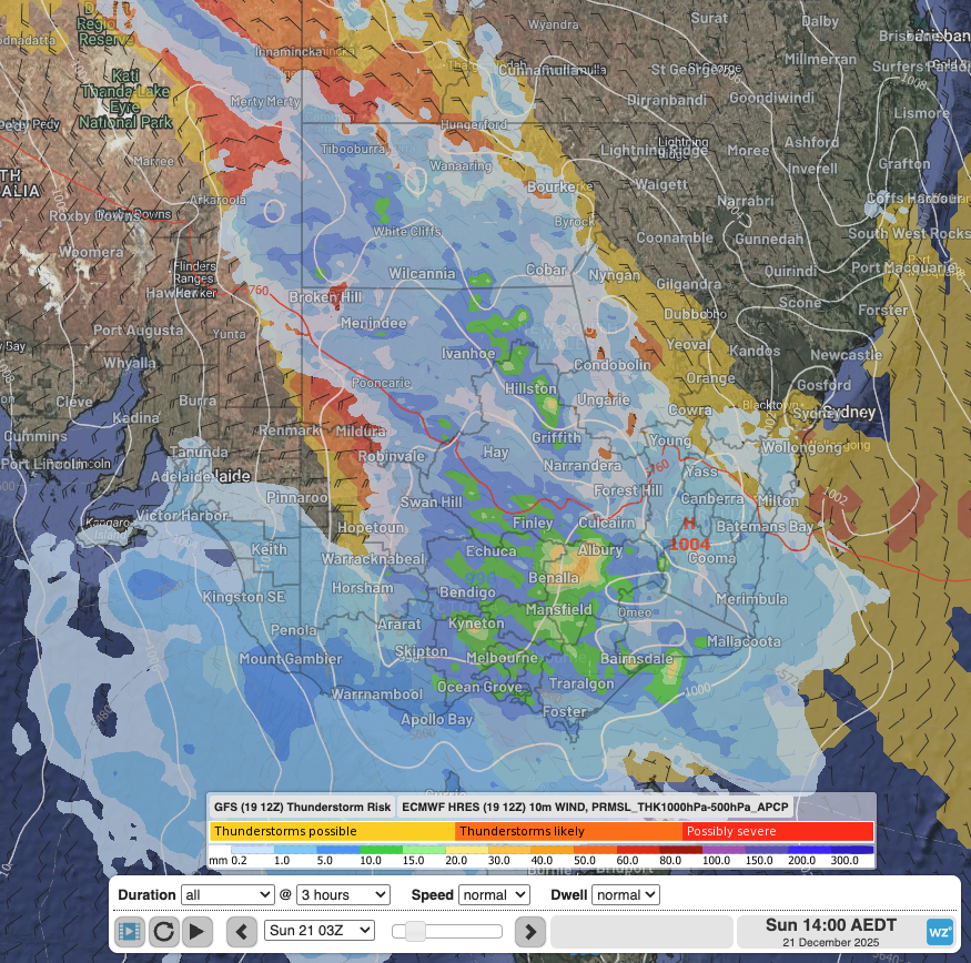
Image: Forecast storm potential according to GFS, 3-hrly rainfall and 10-minute wind according to ECMWF at 2pm Sunday afternoon, showing a swath of stormy rain extending from Vic to southern Qld and the NT. Source: Weatherzone.