
Blustery winds, heavy rain lashed WA, now heading for nation’s southeast
Look at a satellite image right now and you'll see a spectacular swirl of cloud in the Great Australian Bight. But for all its beauty, that swirl, generated by a powerful low pressure system, has already packed a bit of a punch for southern WA and it's now set to impact SA.
As the low skirted the southwest corner of WA on Friday and Saturday, it sent a powerful front over the region, generating gusty winds, thunderstorms and heavy rainfall. Wind gusts of 83 km/h were recorded over coastal areas such as Busselton, Cape Leeuwin and Rottnest Island on Friday, heralding what was to come.
By 9am yesterday (Saturday, June 21), southwest WA had seen some of its most significant rainfall in years, including:
- 48.2 mm at Garden Island – the wettest day of any month in over five years and its wettest June day in at least 22 years
- The wettest day since August 2022 at Berkshire Valley (29.8 mm, its wettest June day in 32 years), Tibradden (39.8 mm, its wettest June day in 13 years) and Strawberry (36.0 mm, its wettest June day in four years)
- 29.0 mm at Bellendaine, its wettest June day in at least 23 years
- 26.0 mm at Canterbury, its wettest June day in 13 years
- 22.0 mm at Dalwallinu, its wettest June day in a decade.
Significant rainfall was also recorded in the 24 hours to 9am at Witchcliffe West (64.0 mm), Jarrahwood (57.0 mm), Cowaramup (54.0 mm), Warner Glen (52.0mm), and Busselton (43.0mm). Even the Perth area got a decent look-in with 47.2 mm for Jandakot, 46.4 mm for Swanbourne and 28.4 mm for Perth Airport.
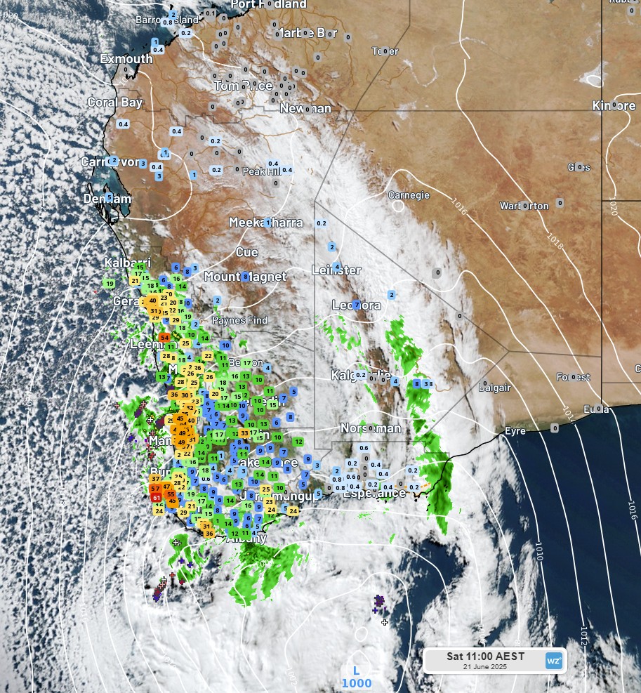
Image: Satellite and radar imagery, together with mean sea level pressure (white isobar lines) and 24-hour accumulated rainfall observations (coloured/numbered squares) at 11:00 am AEST / 9:00 am AWST, Saturday, June 21, 2025.
The gusty winds continued over coastal southwest WA, with gusts of 94 km/h at Rottnest Island, 93 km/h at Cape Leeuwin, 89 km/h at North Island and Cape Naturaliste, and 83 km/h at Red Rocks Point, while important transport hubs like Perth Airport and Busselton Jetty recorded gusts of 72 km/h.
As the low spiralled east toward the Bight overnight, winds began to pick up at Esperance, with gusts of 76 km/h late last night, reaching a crescendo of 89 km/h well before sunrise this morning. Now, the winds are beginning to pick up over the SA coast. A wind gust of 76 km/h was recorded at Minlaton airport on the Yorke Peninsula at around 10 am today, with many parts of central SA and the west coast now consistently experiencing wind gusts of 40-50 km/h. These wind gusts should strengthen later tonight, with gusts of 60-90 km/h expected over SA’s south tomorrow, gusting up to 80 km/h over Adelaide.
As we mentioned in our story on Friday, those winds are then expected to increase over southeastern states in the coming days as the low continues to track east, crossing Tas late on Tuesday, June 24. Damaging wind gusts are expected for parts of SA, Vic, NSW, the ACT and Tas, including capital cities, mainly on Tuesday and Wednesday, as you can see from the images below.
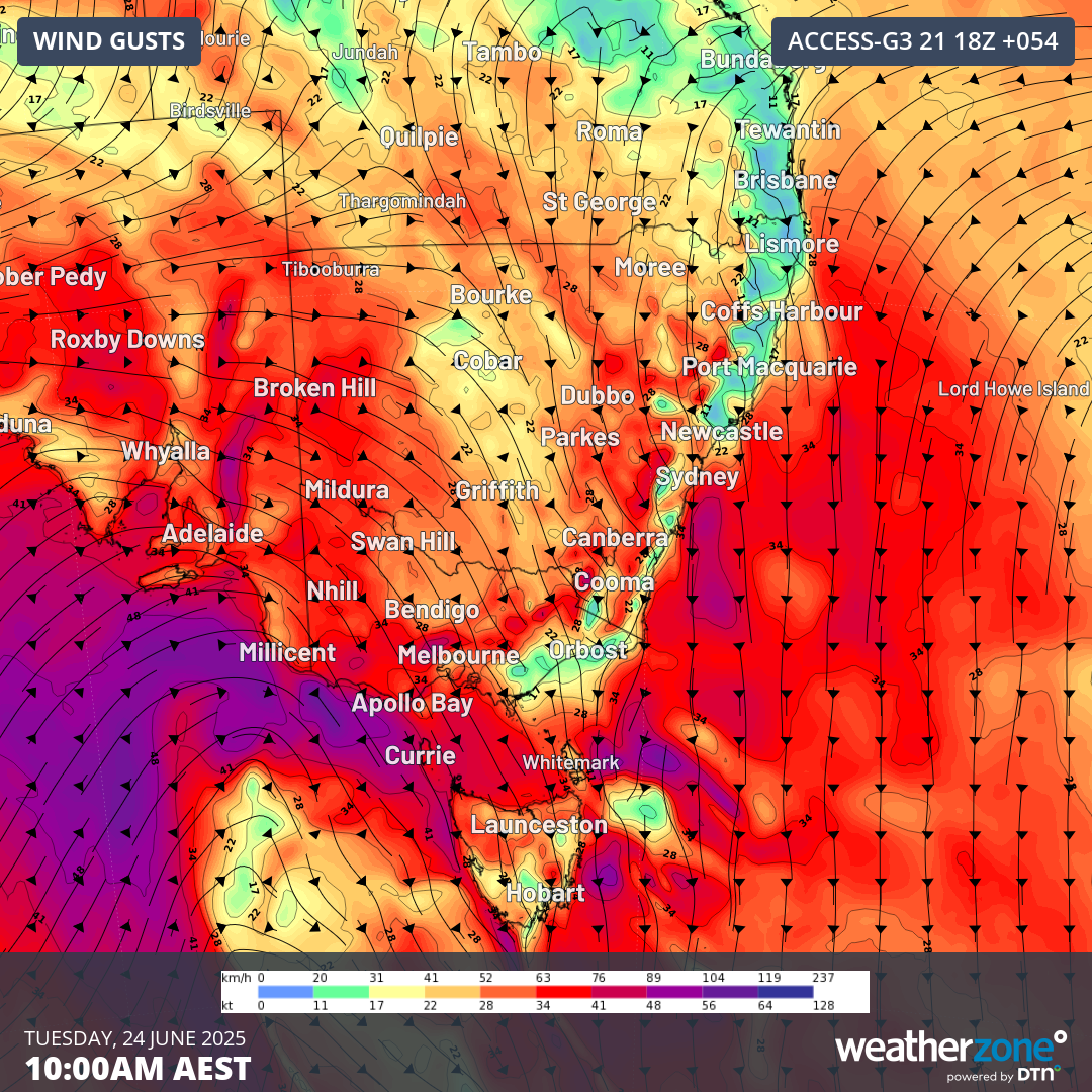
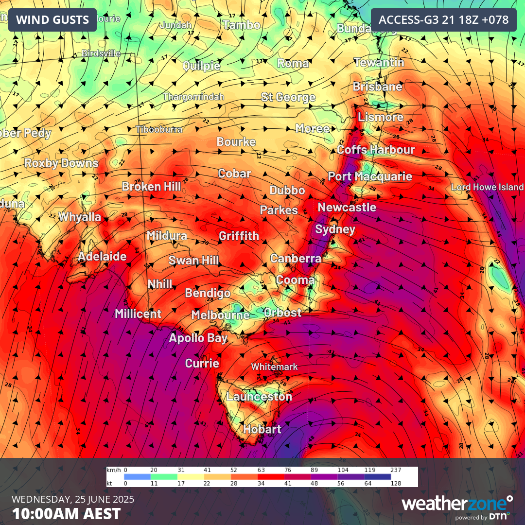 Images: Forecast wind gusts at 10:00 am AEST on (top) Tuesday, June 24, and (bottom) Wednesday, June 25.
As with WA, this system is also expected to bring significant precipitation to the nation’s southeast, particularly over northern Tas and the Australian Alps of northeast Vic and southeast NSW, where rain is expected to fall as snow, which will be welcome news for ski resorts. As mentioned yesterday, there is the potential for blizzards in the Alps, with extremely cold temperatures expected for Vic, Tas, eastern NSW and the ACT as the cold front of this system crosses the southeast.
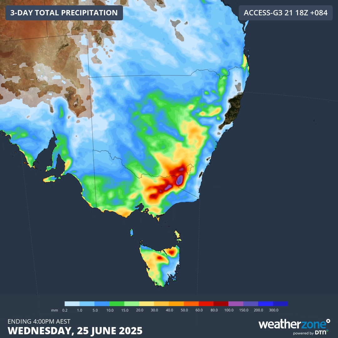 Image: Accumulated precipitation to 4:00 pm AEST, Wednesday, June 25, 2025.
As this system continues to unfold, conditions will significantly deteriorate in southeast states. Be sure to check Weather Warnings over the coming days to stay up to date on severe weather impacting your area.