
Blustery Saturday in NSW
After several towns in eastern NSW registered wind gusts exceeding 90km/h on Friday, a second burst of powerful winds is expected today.
A slow-moving deep low over the Southern Ocean with associated multiple troughs has been affecting this week much of the southern states. A vigorous trough crossed NSW on Friday bringing damaging winds to eastern parts of the state.
Williamtown and Taree saw their highest wind gusts (107 and 82km/h) in 6 years and 2 years, respectively. Westerly wind gusts reached 100km/h in Port Kembla, 95km/h in Moss Vale, 87km/h in Newcastle, 85km/h in Glen Innes, 83km/h in Sydney Harbour, and 82km/h at Sydney Airport.
A front is crossing today eastern Australia and will cause winds to strengthen, possibly peaking in the early afternoon for most places. A severe weather warning for damaging winds is currently in place for eastern districts, including Sydney, and the Lower Western with sustained winds averaging 60 to 70km/h and gusts in excess of 90km/h. With these strong winds, it will make it feel several degrees colder than the actual temperature, so do not forget an extra layer if you go outside and watch out for falling branches.
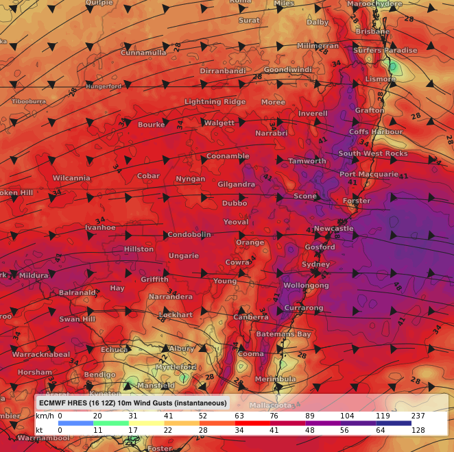 Image: Blustery westerly winds over NSW on Saturday early afternoon accoding to the ECMWF-HRES model.
The system will also continue to trigger a few showers on the ranges and western slopes with possible thunderstorms and small hail, and snow falling above 800 metres over the Central Tablelands. If you live in Orange or Lithgow, you may see a dust of snow. The highest chance to get decent snowfalls, outside the Alpine area, will be around Oberon and Jenolan Caves.
These dangerous weather conditions will start to ease in the evening as the front moves offshore. A high over central Australia will extend a ridge over the state on Sunday bringing settled conditions and allowing temperatures to plummet overnight.