
Australian snow season nears one metre, but warm weather coming
The 2026 Australian snow season continues to be below average by historical standards, but the good news is that the snow depth at the highest elevations of the mainland alpine region has reached around one metre.
The latest reading at Spencers Creek (elevation 1830 m) – the highest of three NSW sites where hydro-electric operator Snowy Hydro has regularly measured the snowpack in the cooler months since 1954 – was 94.5 cm.
That’s a modest improvement of around seven centimetres from last week, after heavy weekend rain eroded the snowpack before moderate snowfalls at higher elevations this Monday and Tuesday topped it up.
The not-so-positive news for snow enthusiasts and for businesses that depend on the snow trade is that a warm spell is coming, with no significant snowfalls on the horizon until the end of next week at the earliest.
Let’s quickly recap the season so far before previewing the next week or so of weather in the high country.
2026 to date: a season of moderate snowfall accumulation
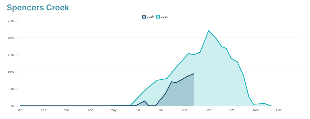
Image: Snow depths at Spencers Creek, NSW in the 2026 Australian snow season to date (dark blue) compared to 2025 (light blue), which was a slightly above-average snow season. Source: Snowy Hydro.
The 2026 season started with a promising snowfall just before the traditional King’s Birthday long weekend opening in early June, before the weather turned mostly warm and wet. For just the second time since 1954, there was no measurable snow at Spencers Creek at the start of July.
July was colder than June but it was also drier, and while at least three snowfalls brought the season to life, none of them were particularly heavy, with the Spencers Creek depth around 70 cm as July turned to August. That was well below the average of around 120 centimetres for that point of the season.
Thus far in August, there have been two moderate snowfall events.
While the majority of lifts are now open at the higher Australian ski areas – with all lifts spinning at the NSW resorts of Thredbo and Charlotte Pass – the snowpack is still moderate for this time of year.
Indeed, if no significant snowfalls arrive later this month, 2026 could potentially be just the third season on record when the snowpack at Spencers Creek falls short of a metre (the others were 1982 and 2006).
Like this year, both 1982 and and 2006 were El Niño years.
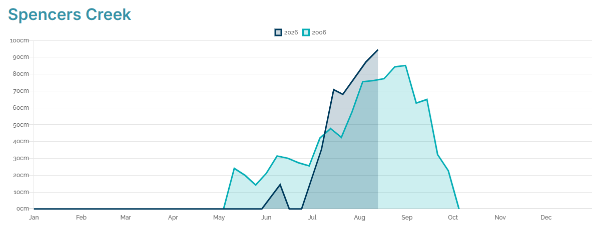
Image: The 2026 Australian snow season to date at Spencers Creek (dark blue) compared to the worst snow season on record in 2006 (light blue) when the peak Spencers Creek snow depth was just 85.1 cm. Source: Snowy Hydro.
Snowfall prospects for the coming week
If you’re lucky enough to be heading to the snowfields this weekend, expect mild days by August standards and mostly clear conditions with moderate breezes that shouldn’t be strong enough to stop lifts from running.
Maximum temperatures over the next seven days will be quite springlike, reaching 5°C or slightly warmer at all alpine weather stations.
The next moisture-laden system crossing southeastern Australia doesn’t appear on the charts until the second half of next week – and at this stage, it’s unclear whether it will be cold enough for significant accumulations of fresh snow.
Please check the Weatherzone snow page for the latest live snow cam images, forecasts and more.