
Atlantic Hurricane Season 2026: A remarkably quiet start
While the eastern and central Pacific are having a busy summer of tropical storms, the Atlantic hurricane season has had an abnormally quiet beginning.
From Arthur to Dolly – the season so far
Peak activity for the Atlantic hurricane seasons typically occurs between mid-August and mid-October, and the average peak is around September 10th.
Despite being close to the climatological peak of the season, there is not much happening at the moment.
A tropical depression in the northern Gulf will bring some heavy rain to the coasts of LA and northeast TX on Tuesday and Wednesday. This system may become a tropical storm before crossing the coast.
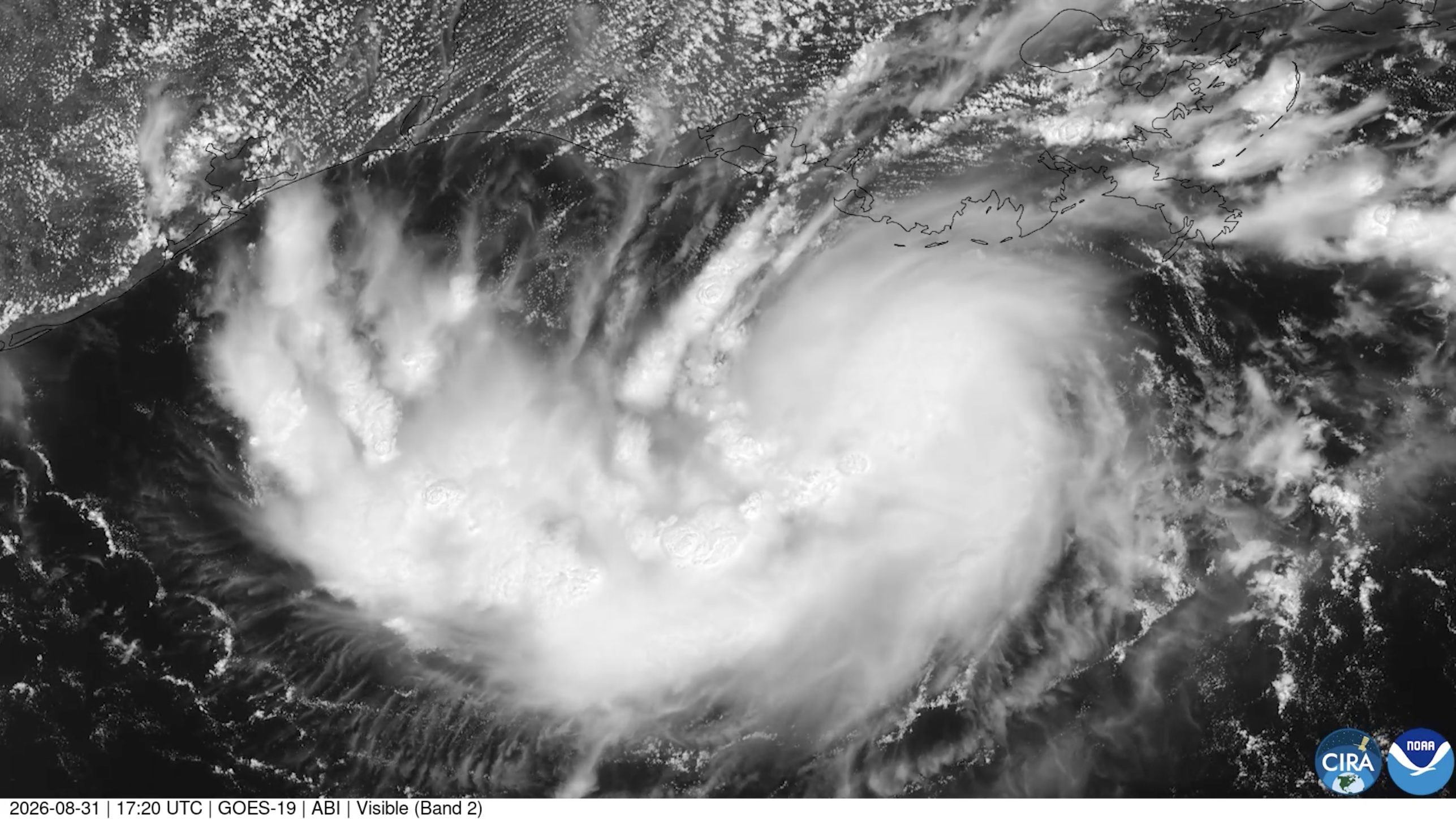
Image: Satellite image showing a tropical depression off the northern Gulf Coast on August 31, 2026. Source: CIRA / GOES-19.
Further east, the remnants of Tropical Storm Dolly will have a very low risk of reinvigorating while moving towards the Bahamas, the southeastern Gulf or far southern Florida in the coming days.
Dolly was only the fourth named Atlantic storm so far, following Arthur, Bertha and Cristobal, none of which attained hurricane strength. Arthur and Cristobal were weak and short-lived tropical storms, while Bertha became stronger but still only had winds peaking at 58 mph.
By August 25th, the Accumulated Cyclone Energy (ACE) index for the Atlantic was running at 3.1, which is more than 80% below average, while the Pacific was above normal. ACE measures the activity of a hurricane season by combining the number of systems with their longevity and intensity.
El Niño creating battle between wind shear and warm water
One overriding factor that is having a notable influence this season is the very strong El Niño that continues to gain strength in the tropical Pacific. El Niño events induce a favorable environment for tropical storm development in the Pacific but create hostile conditions for hurricanes across the Atlantic.
El Niño suppresses hurricane development because it increases vertical wind shear (change of wind speed and/or direction with height) over the Atlantic, which serves to tear nascent storms apart. This appears to be the fate facing Dolly. Hurricanes require relatively little change in winds through the troposphere (lowest section of the atmosphere) but during El Niño there tends to be a westerly flow of winds high up, while easterlies prevail near the surface.
Surface waters in the Atlantic are easily warm enough to fuel a tropical storm in the Main Development Region (MDR), with temperatures above 80 degrees F. So, there is a bit of a tug-of-war between warms seas and wind shear, which the latter is currently winning.
However, even during a strong El Niño, temporary reductions in wind shear can create opportunities for rapid hurricane development, especially over the exceptionally warm waters of the Gulf, the Caribbean or the far western tropical Atlantic.
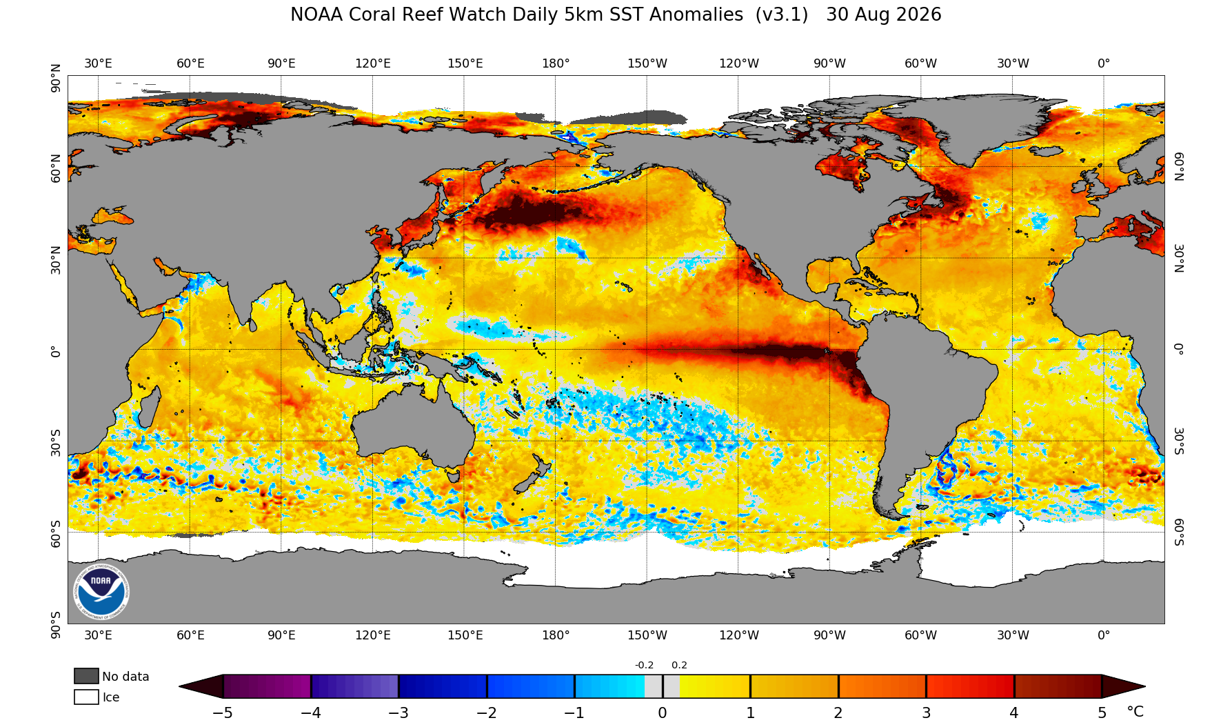
Image: Sea surface temperature anomalies on August 30, 2026, showing warmer-than-normal water over the central and eastern tropical Pacific associated with El Niño. Water is also warmer than average in the Atlantic Ocean and the Gulf. Source: NOAA.
Easterly atmospheric waves
Usually at this time of year, vigorous atmospheric waves and thunderstorms emerge from West Africa into the tropical Atlantic, near Cape Verde (Cabo Verde) and travel across the MDR, where they would ordinarily, under favorable circumstances, develop into cyclones and intensify, using oceanic warmth and moisture as fuel.
However, the disruptive wind shear caused by El Niño plays a role here as well, suppressing the development of easterly atmospheric waves or weakening them before they have a chance to form a circulation. During strong El Niño years, fewer tropical storms and hurricanes develop from African easterly waves than usual.
Dry air and dust
Another consideration is the intrusion of layers of dry air and dust, because hurricane development needs a deep layer of atmospheric moisture.
This year there have been greater than usual instances of dry and dusty air moving out of Africa and over the tropical Atlantic. This is known as the Saharan Air Layer (SAL), which appears every year to a greater or lesser extent, and is most apparent between June and August.
The SAL contains around 50% less moisture than average for the tropical atmosphere, and if this drier air becomes entrained in easterly waves, it increases evaporation within thunderstorms, which can increase downdrafts and suppress updrafts and convection and limit vertical growth of cumulonimbus clouds. As a result, tropical waves can struggle to get organized when they are affected by the SAL.
There is no particular quality inherent in dust particles that cause them to suppress development. Instead, visible dust in a satellite image is an identifier of three things: a dry air mass, strong mid-level winds (causing increased vertical wind shear), and a relatively stable mid-level atmosphere (subduing convection) – all of which are known to suppress hurricane development.
Looking ahead
SAL outbreaks tend to lessen as September approaches. That’s one reason that the Atlantic hurricane season usually becomes more active around this time and reaches a peak by mid-September. We may, therefore, see an increase in cyclonic developments but these will still have to struggle against the increased wind shear inherent in an El Niño summer.
The latest outlook from NOAA forecasts 7-13 named storms, 2-6 hurricanes and no more than 2 major hurricanes, with ACE of 30-90% of the long-term median.
Notably, every Atlantic hurricane season since 1950 that has coincided with a strong El Niño has produced below-normal tropical activity in the Atlantic.