
Arctic air is poised to return across the north and east
Winter has made no bones about arriving across the northern and eastern US. Temperatures are going to rise somewhat in the coming days, but another Arctic outbreak will arrive later this week, targeting the Midwest in particular.
The most potent shot of cold for the week should arrive over the Upper Midwest and Ohio Valley through Friday and the weekend, with the lowest temperatures on Saturday, dropping 20-30 degrees below normal.
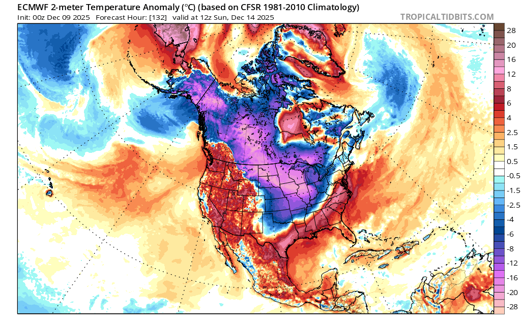
Image: ECMWF model forecast for 12:00 UTC on Sunday December 14th of surface temperature anomalies. Source: TropicalTidbits.com
Clipper systems and lake effect snow
The cold weather arriving later this week will follow an active period across the country’s North and Northeast, with a parade of clipper systems moving through, taking bouts of snow from the Northern Plains through the Midwest and Great Lakes to the Northeast. Snow could also extend southwards across the OH Valley and Mid-Atlantic.
There will also be some strong winds on Wednesday and Thursday, and again at the weekend, with bands of lake effect snow developing to the east and south of the Great Lakes.
The cold air will expand through the East from the weekend into next week, especially across the Northeast and Mid-Atlantic, although the depth of cold will moderate somewhat.
Sharply divided pattern across the US
This week’s cold outbreak in the North and East contrasts dramatically with persistent warmth across the western US, with temperatures above to well above average, thanks to the continuing presence of an upper ridge of high pressure.
The central US will find itself near the dividing line between warm and cold this week, with south central regions experiencing a fight between these air masses, cooling down this weekend before warming again next week.
The flip side to the western high pressure is a sharp trough digging southwards across the eastern US, in an amplified pattern that has the jet stream reaching far northwards in the West and plunging unusually far south across the East. Frigid air pooling over Canada therefore has little getting in the way of it tumbling southwards.
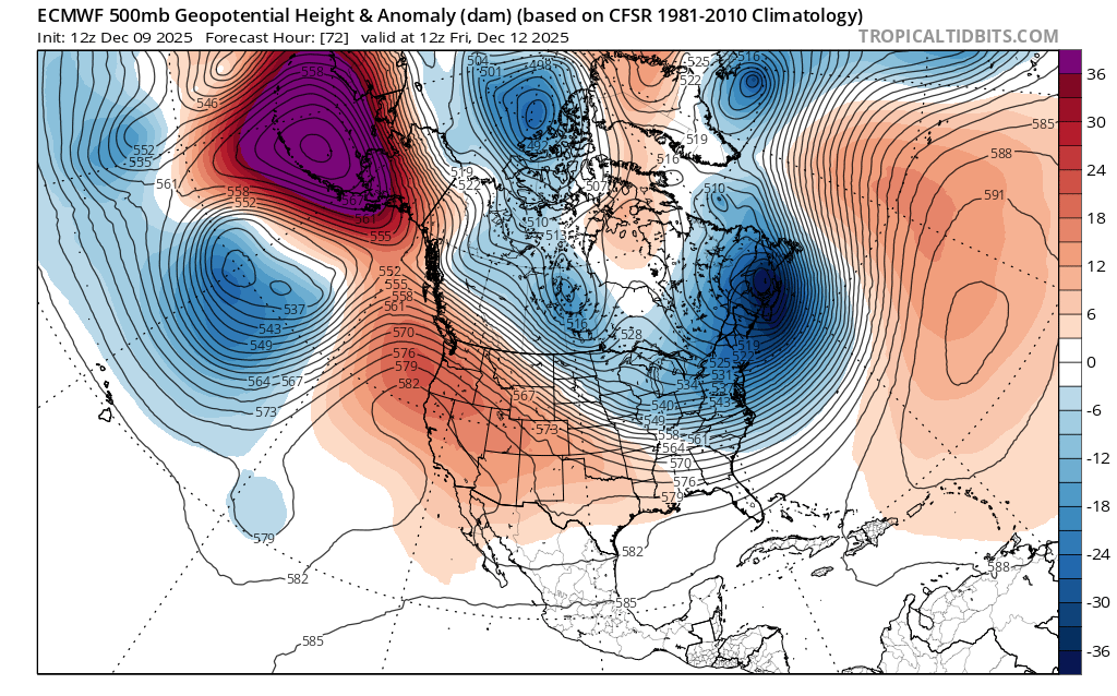
Image: ECMWF model forecast for 12:00 UTC on Friday December 12th of 500 hPa heights. This shows a high pressure ridge from the western US to the Bering Sea and a low pressure trough downstream across Canada and the eastern US. Source: TropicalTidbits.com
A negative WPO pattern and other drivers
In the background holding all this in place is a remarkably robust high pressure block in the vicinity of the Bering Sea, with near-record intensity. This represents a strongly negative phase of what is called the Western Pacific Oscillation (WPO), which favors cold weather across Canada and the eastern USA.
Underlying that, we are about at the peak of a weak La Niña episode in the equatorial Pacific, with the coldest waters near the dateline. This tends to encourage colder winters in the US. A shorter-range variable in the tropics, over a matter of weeks rather than a season, is the Madden-Julian Oscillation (MJO), a cluster of convection that travels eastwards around the globe and impacts both tropical and extra-tropical patterns. Its current track across the Pacific is also favorable for cold outbreaks.
The weakened stratospheric polar vortex this December is also a factor in more amplified patterns around the northern hemisphere, and greater susceptibility to Arctic outbreaks.
A milder trend by Christmas?
Below-average temperatures could grip parts of the Midwest and Northeast through most of the next couple of weeks, and we must be wary of weather models that might try to show a more rapid warm-up. There are some signs of the broad atmospheric pattern relaxing and shifting as Christmas approaches, allowing some milder air to finally infiltrate, although that doesn’t rule out a recurrence of the negative WPO pattern in the New Year.