
Acropolis snow: Athens coated in white
Heavy snow has coated the Greek capital Athens all the way to sea level, as a strong winter storm named "Elpida" sweeps its way all the way to the Mediterranean coastline from much colder regions further north.
Bus, train, and air services have all been severely disrupted as snow fell as far south as the island of Crete, about 300 km south of Athens.
Extremely heavy snow was also reported along Turkey's coastline. Istanbul, which lies at sea level, reportedly had up to 80 centimetres in a significant blizzard which temporarily closed the airport.
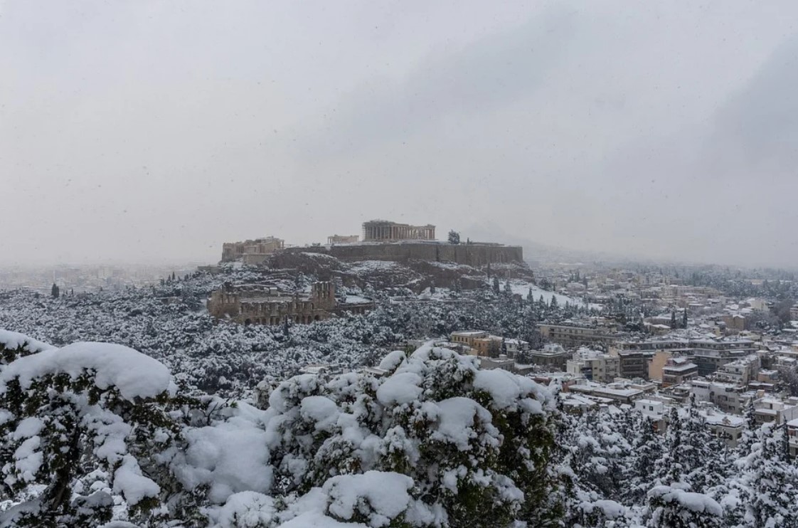
Image: Elpida* turned the Acropolis white. (*Some European meteorological agencies name winter storms) Source: Antoniis_fr via Pixabay.
Why the snow in a place we usually associate with warm weather?
The best way to answer that is by comparing Athens to another city known for its large Greek population – our very own Melbourne.
Athens is almost exactly the same latitude north of the equator (37.9° N) as Melbourne is south of it (37.8° S). So it's no surprise that Athens can get a little chilly in winter. But snow?
Why does Athens sometimes get snow all the way down to sea level while Melbourne only gets winter rain and hail until you gain altitude in the nearby hills and mountains?
A tornadic waterspout came ashore on the snow-covered island of Andros in Greece on Monday. Yep, it’s a #snownado! There has also been heavy snow in #Athens.
— Ben Domensino (@Ben_Domensino) January 24, 2022
📹: @meteogr pic.twitter.com/mIRcAy2y3V
The answer lies in the proximity of Greece to eastern Europe. In essence, Melbourne has ocean between it and Antarctica. But Athens has land between itself and the polar regions.
As Weatherzone meteorologist Ben Domensino explained in this story we wrote about the severe Texas cold snap in February 2021:
"The US gets much colder than Australia because they are connected to the Arctic by land. Cold polar air can easily travel across Canada and into the US without warming up too much.
"By contrast, Australia is separated from Antarctica by the vast Southern Ocean. This large water body causes air to warm up a lot more as it moves into the mid-latitudes."
So in essence, a similar thing can happen in parts of southern Europe along the Mediterranean coastline as happened in the US last winter. Just occasionally, a really strong polar outbreak extends far another south to turn normally mild areas frigid.
The Parthenon in snow, Athens, 24 January 2022. pic.twitter.com/69RwTk8mJ4
— Dr Kalliopi Nikita (@KalliopiNikita) January 24, 2022
The same thing happens in Australia when a strong Southern Ocean cold front marches northwards. But as mentioned, the ocean moderates temperatures to an extent, so that only colder, elevated mountainous areas receive snow.
Anyway that's why it's snowing in Athens. And for the weather enthusiasts out there, here's a chart from the ECMWF (European Centre for Medium-Range Weather Forecasts) to illustrate the current synoptic set-up.
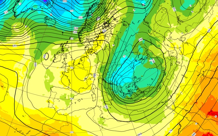
Image: Current synoptic chart on Jan 25 showing the cold snap over southeastern Europe. Source: ECMWF.
If that all looks like gobbledygook to you because your brain can't handle the way northern hemisphere charts are in reverse, we've flipped it upside down for you below.
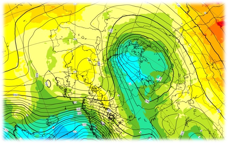
Image: The same chart from a down under perspective. Ah, that's better! Source: ECMWF.
Now you can see how an area of really cold air has made its way towards the Mediterranean.
And while the snow in Athens looks like drying up today, cold air should stick around for at least another couple of days in that classic crisp but sunny post-frontal weather that citizens of our own capital city – Canberra – could relate to.