
A weekend of showers and thunderstorms for NSW and ACT
A cold front and low pressure system will cross New South Wales and the Australian Capital Territory this weekend bringing widespread showers and thunderstorms.
Showers have already started ahead of the system in the far south and west of the state. There is the chance of more than 25mm over the 2 days for areas in the southeast, particularly the alpine areas and with any thunderstorms. 5-25mm of rain may occur for a large portion of the state and territory over the weekend.
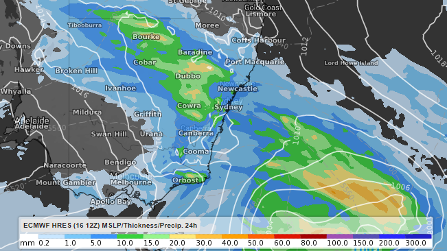
Image: 24hour accumulated rain totals to 5pm EST Sunday. ECMWF model displayed.
Thunderstorms may occur in the south and far west from early afternoon Saturday, extending further east as the day rolls on. The highest chance of thunderstorms looks to occur from Griffith to Broken Hill and coastal areas from the afternoon. The ACT may also see a few storms from Saturday afternoon, however, these are expected to clear by early Sunday morning. There is potential for some of these storms to produce damaging winds, heavy rainfall and large hail so be sure to keep an eye on warnings for your area here https://www.weatherzone.com.au/warnings.jsp.
Showers and storms should move further to the northeast of the state throughout Sunday, contracted to the far northeast by Monday.