
A very, very Melbourne week of weather
If you don't like the weather, just wait five minutes. That's the classic old saying about Melbourne weather, and it definitely looks like it will apply for the next week or so.
Persistent showers are streaming across the city today in a classic chilly southwesterly winter flow in the wake of a cold front and associated trough.
Between the showers, large dollops of sunshine are on offer, until you pop out to grab a sandwich for lunch – you know the drill if you live in Melbourne – and rain hammers down for those crucial few minutes before quickly clearing again.
How much rain has fallen/will fall?
By midday Tuesday, nowhere in the greater Melbourne metro area had received more than 5 mm, while 1.2 mm had fallen in the city – most of it in a brief burst before 11 am.
That has been the pattern for most of August to date. Rain has fallen on eight of the 16 days to date this month with just 12.6 mm accumulating overall in the gauge (with a little more in the city's east, as often happens with winter weather systems). Like we said, it's classic Melbourne weather: frequent showers which often don't amount to much overall.
The same pattern looks likely to continue for the next seven days, with a few millimetres of rain expected on each day except Sunday, when there's just the slight chance of a light shower. Rain is likely to be heaviest on Thursday and Friday as a cold front crosses Victoria, with up to 10 mm possible on both days.
What about the Victorian floods?
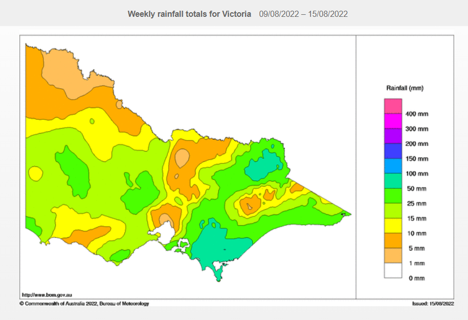
Image: Vic weekly rainfall from Aug 9 to 15. Source: BoM.
Interestingly, Melbourne dodged the heavy weekend rain that lashed Gippsland. You can see an indication of that on the Bom weekly rain chart above.
The chart also shows that a large chunk of south Gippsland received between 50 mm and 100 mm of rain. That's the large, teal-coloured section.
Gippsland resident Steve Mesaric told Weatherzone there was "loads of rain" that flowed down from the Strzelecki Ranges into low-lying paddocks, inundating them.
A moderate flood warning remains in place for the La Trobe River, and several minor flood warnings are also in effect for other creeks and waterways. Please check our warnings page for the latest.
Eastern parts of Victoria away from the mountains can expect rainfall totals similar to Melbourne's for the rest of the week, so with luck, there'll be nothing heavy enough to exacerbate the existing flood situation.
Meanwhile, Melburnians should take an umbrella to work every day this week, just in case.

Image: Or you could just ride a tram all day. Rain problem sorted! Source: @wimkantona via Pixabay.
But as mentioned, you can also expect frequent patches of blue. Top temps should be a degree or so either side of 15°C all week, although it will start to feel colder as the wind picks up from midweek.