
260mm in a day in South East Queensland deluge
At least five locations have exceeded 24-hour rainfall totals of 200mm, with daily totals of 100mm or higher across a broad sweep of central and South East Queensland.
The image below shows the location of the state’s most intense bursts of rainfall in the 24 hours to 9am Monday, March 9. Readings in bright blue represent 200mm or more.
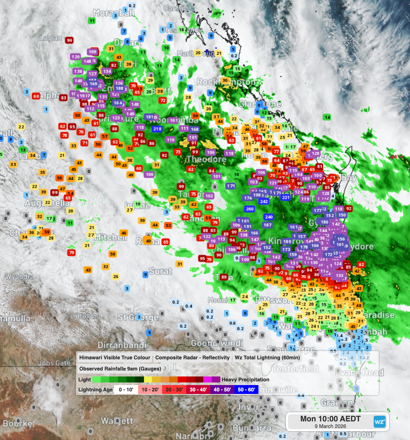
Image: Rainfall totals for parts of central and SE Queensland in the 24 hours to 9am (AEST) on March 9, 2026. Source: Weatherzone.
Notable rainfall totals in the 24 hours to 9am Monday included:
- 260mm at Brovinia, a rural locality in the Wide Bay and Burnett forecast district.
- 218mm at Planet Downs, a cattle station in Qld’s Central Highlands and Coalfields forecast district.
- 199mm at Bowen Downs, which was just short of the 200mm mark but was still a huge fall for the cattle station in Queensland’s Central West forecast district.
- 180mm at Kingaroy, which was the heaviest day of March rainfall on record in data going back to 1906, and the wettest day in any month for 13 years.
- 59.6mm at Brisbane Airport, which was at the southern tip of the heaviest band of rain. Heading south through Brisbane’s suburbs and onto the Gold Coast, 24-hour totals tended to be above 10mm but below 50mm.
What caused the heavy rain?
An interesting aspect of the current system is that falls were heavier inland than at many coastal locations.
A good example is the 180mm that fell at Kingaroy. The town of 10,000 is just under 200km west of the Sunshine Coast, and while virtually all of the Sunshine Coast received more than 100mm, Kingaroy’s reading was slightly higher than most coastal weather stations.
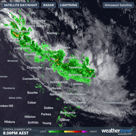
Image: 12-hour radar and satellite loop over SE Qld to 8:30am (AEST) on March 9, 2026. Source: Weatherzone.
In short, this is because moisture poured in from a northwesterly direction.
"A tropical low moved inland and dragged moisture from the monsoon trough all the way through to South East Queensland,” Weatherzone meteorologist Joel Pippard explained.
"There’s an expectation that a secondary low pressure system will start to spin up off the Queensland coast later on Monday," Pippard added.
How long will this rain persist?
The current band from the northwest is still delivering steady rainfall to areas north of the Gold Coast, with heavy rain starting to pick up in Brisbane.
Just before 10:30am (AEST), the BoM issued a severe weather warning for locally intense rainfall and damaging winds for all or parts of the Capricornia, Wide Bay and Burnett, Central Highlands and Coalfields, and Darling Downs and Granite Belt forecast districts.
With the likelihood of the low developing offshore later day, rainfall could briefly intensify near the coast. But the low should push out to sea quite quickly, with SE Queensland weather clearing quite rapidly from Tuesday onwards.
What is the flooding situation?
More than 300 roads were closed across SE Queensland on Monday morning, with flooding occurring in low-lying areas of numerous towns. The full list of road closures is available at the Qld Traffic website.
Numerous flood warnings are also in place for Queensland rivers, including at least five major flood warnings – the highest level of riverine flood alert.
Please check the Weatherzone warnings page for the latest.