
135 km/h winds batter WA, with SA and Victoria next in line
Damaging winds will hit parts of Western Australia, South Australia and Victoria on Monday as a large low pressure system passes to the south of Australia. The powerful system will then cause wet and windy weather to continue over the country’s southeast through the middle of the week.
Wild winds slam WA
Ferocious winds brought down trees and cut power to tens of thousands of customers in WA’s west and southwest over the weekend. While wind and rain picked up on Saturday night with the arrival of a cold front, the strongest winds occurred late on Sunday as the low pressure system slammed into the state.
Wind gusts reached up to 135 km/h at Cape Naturaliste and 133 km/h at Cape Leeuwin on Sunday evening. Other notable gusts from Sunday included:
- 120 km/h at Busselton Jetty
- 108 km/h at Jerdacuttup
- 107 km/h at Ravensthorpe
- 104 km/h at Garden Island
- 104 km/h at Mandurah and Mount Barker
- 100 km/h at Jandakot Airport
- 98 km/h at Dwellingup
- 93 km/h at Perth Airport
Wind will ease in western areas of WA on Monday as the low moves further east. However, damaging wind gusts will continue to affect the state’s south, including the Eucla, South East Coastal and parts of Goldfields, South Coastal, Great Southern and Central Wheat Belt districts.
Rain and damaging winds spreading further east
As the low pressure system moves further east, wet and windy weather will spread over southern and southeastern Australia during the next few days, impacting parts of SA, Vic, Tas, NSW and the ACT.
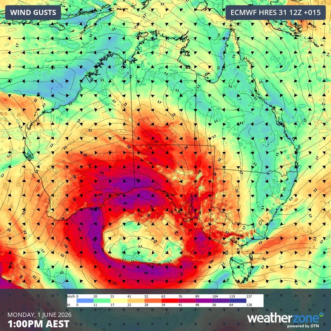
Image: Forecast wind gusts at 1 pm AEST on Monday, June 1, 2026. Source: Weatherzone.
Damaging wind gusts are likely to affect parts of SA and Vic on Monday, possibly including Adelaide and areas near Melbourne. Damaging winds are also likely to spread into parts of NSW from Tuesday, most likely about the southern and central ranges.
The large and slow-moving nature of the low pressure system will cause several days of rain across southern and southeastern Australia between Monday and Thursday. The heaviest falls from this system will occur in areas exposed to westerly component winds.
Accumulated rainfall totals of 50 to 100 mm are possible in southern, central and northeast Vic and southern NSW between Monday and Thursday. More widespread totals of 20 to 50 mm are possible in SA, Tas, Vic, NSW and the ACT over this four-day period.
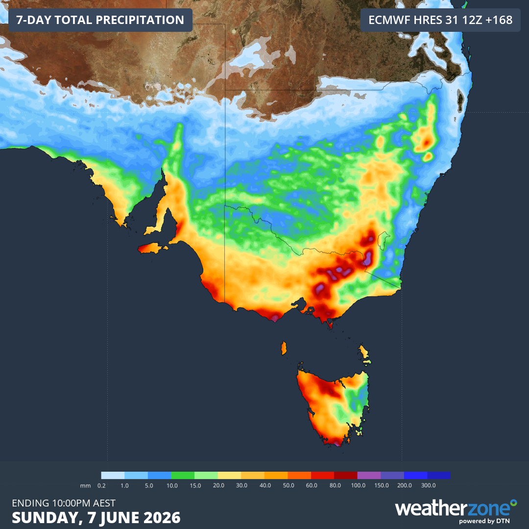
Image: Forecast accumulated rain during the next seven days, although most of this will fall between Monday and Thursday. Source: Weatherzone.
There may be enough rain to cause flooding in parts of Vic and southern NSW this week, particularly in areas of the ranges that have potential for accumulated totals above 100 mm.
Some of this week’s precipitation will also be falling as snow in the higher terrain of southeastern Australia, adding some much-needed natural snow to the ski slopes in the opening days of winter.
With severe weather likely to affect multiple states in the coming days, be sure to check the latest forecasts and weather warnings for your area for the most up-to-date information.