
Widespread useful rain predicted for first week of November
The first week of the last month of spring should be a wet one across much of Australia – the key question is how wet?
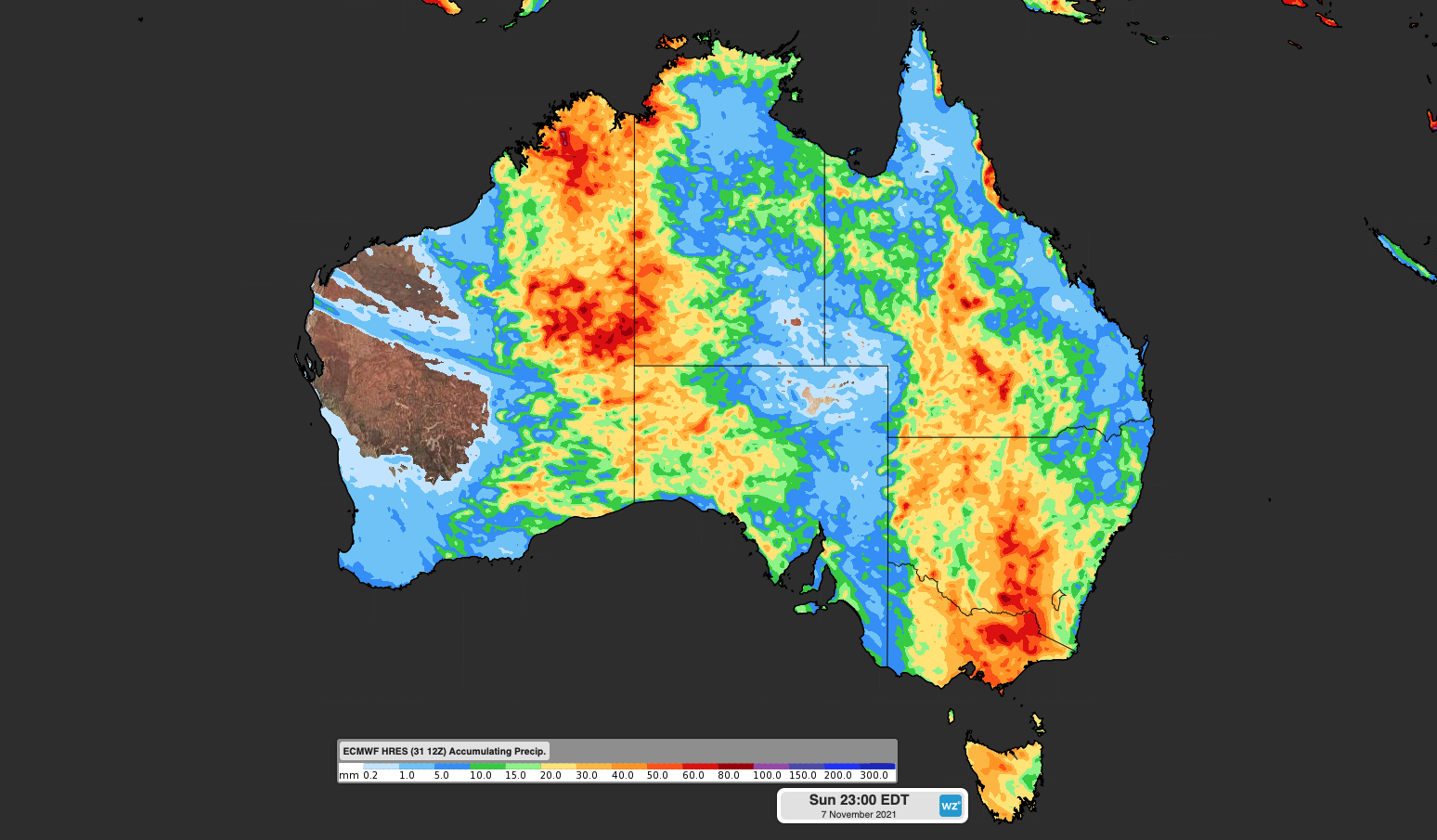
The image below shows the extent of the rain expected over the next seven days. As you can see, a huge portion of the continent is expected to get at least some rain, give or take a chunk of Western Australia’s Gascoyne and Pilbara regions.
So what's happening?
The widespread rain and thunderstorms are all thanks to tropical moisture which will feed into a series of low pressure troughs throughout the week. There will be no new injection of cooler Southern Ocean air for the entire working week, in a sign that winter-type weather patterns are losing their impact as summer approaches.
This week's rain is being underpinned by the negative Indian Ocean Dipole (IOD) which has been in place since July.
So there is moisture in place, and on other side of country, the developing La Nina is also having an effect in terms of the availability of moisture (the Bureau of Meteorology will very likely be declaring a La Nina in coming weeks).
READ MORE: WAIT, WHAT IS THE IOD AGAIN?
So which areas can expect the most rain?
At this stage, this week's rainfall appears as though it will originate in the tropics and venture further south more periodically. Victoria and Tasmania should see most of their rain a little later in the week (after a dry, warm Melbourne Cup Day on Tuesday).
Many outback areas should also see a good drop here and there, and while the exact areas that see decent rain are difficult to pinpoint, it seems likely that western NSW should see much-needed rain in some areas after a relatively dry October.
As for the capital cities:
- Adelaide might get lucky with 5mm or a little more midweek, but at this stage, it doesn't appear to be in the firing line for the heaviest falls from this system.
- Melbourne should receive more than 10mm on Wednesday and Thursday (combined), with the chance of more significant totals above 20 mm based on current models.
- Hobart will also start to get wet on Wednesday into Thursday, but falls could be heavier in the north of the state.
- Canberra had almost no rain in the last two weeks of October (just 0.6 mm) after a wet first-half of spring, so the 10mm or slightly more due later this week will be very welcome.
- Sydney has the potential for light rain from Thursday through to Sunday, although no significant totals are on the cards at this stage.
- Brisbane could see light showers from Tuesday onwards, but the whole of SE Queensland is not expecting much more than a brief ground-wetting from this week's systems.
- Darwin has the potential for showers and storms every day this week, as the wet season kicks into gear.
- Perth could see a very light shower today and Tuesday but it's looking like clear skies and mild temps for the rest of the week.
Overall, while this week's systems do have an Australia-wide footprint as mentioned at the start of this story, this may be the sort of week where rain falls beyond the cities and most populous parts of the country.
Here's hoping rain falls where the farmers most need it.