
Cool relief for southern capitals
"Phew!"
That's the word no doubt being uttered by countless people in southeastern Australia, as cooler air tracks westwards across southern parts of SA, Victoria, and Tasmania.
The cool air will surge northwards on Wednesday, with maximums tumbling by as much as eight degrees from Tuesday's max in Sydney and Canberra.
For example:
- Canberra reached 29.4°C on Tuesday. It's tipped to reach 21°C on Wednesday.
- Sydney reached 31.9°C on Tuesday. It's tipped to reach 24°C on Wednesday.
Perhaps the most dramatic indication of the strength of this change was in Melbourne, where the cool airmass moved through the city overnight.
- At midnight last night in Melbourne, the temperature was a very balmy 26.4°C.
- At midday today it more than five degrees cooler at 21.3°C.
- Today's maximum in Melbourne was 23.6°C.
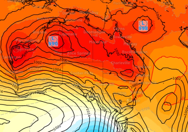
It's all thanks to a cold front which Weatherzone meteorologist Joel Pippard first alerted us to on Sunday. The cooler air, indicated by the mass of blue, white and pale yellow, is well illustrated in the chart above from 5 pm on Tuesday afternoon.
In the wake of the front, winds should swing to the south on the east coast and there'll be enough of an onshore influence to deliver showers all the way along the NSW coast for much of the rest of the week, including to Sydney.
Rain will be heaviest on the NSW North Coast, with possible heavy falls on Wednesday and Thursday.
And for those wondering when exactly the cool air will reach Sydney, early indications suggest that it won't be till around dawn, so we're sorry but another sleepless night could be in store.