
Alpine snow on the way
The first alpine snow dump of the season is forecast for late this week with a multi-day cold outbreak.
Falls of 30-50cm are likely about the higher peaks (above 1800m) during Thursday and Friday, with 10-20 cm as low as 1500m.
A strong cold front (which we've already mentioned here) will cross the NSW/VIC alps late Wednesday 4th and early Thursday 5th. Precipitation will start as rain over the alps on Tuesday night before turning to snow Thursday morning when the low-level cold air arrives.
Unlike some winter cold fronts that lack the deep humidity necessary for good snow formation, this system looks to contain abundant mid-level moisture. This moisture should persist between the first front and another cold surge/secondary cold front arriving on Friday 6th, leading to a good 36 hours of snow accumulation.
A further cold front arriving over the weekend will then maintain snow showers. These snow showers will favour Victorian resorts south of the Main Range in the post-frontal southwesterly airstream, adding a further few centimeters to accumulated totals.
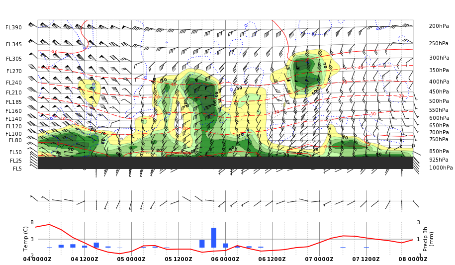
Image: Cross section for the Perisher area between 11am local time (00Z) May 5th and 11am (00Z) May 8th, showing temperature (red lines), humidity (green shading) and wind (black barbs) with height. The number next to FL refers to the height in hundreds of feet. The green shading (>60% humidity) at around 10,000 feet (FL100) can clearly be seen up to later on Friday 6th.
As ever, there is some uncertainty, with a sneaky low pressure system forming behind the first front potentially cannibalising some of the shower activity on Friday. Either way, the coldest air looks like being over the region Friday morning, when the snow level could briefly drop to 1100m.
Also as ever with winter cold fronts, accompanying northwest then west-southwest gales are likely with these systems.
Warnings are likely to be issued for this system as it approaches, so stay up to date here.