
Weird weather week: why northern NSW was colder than southern Victoria
Well, that was a strange week of weather.
Much of NSW endured frigid temperatures and highland snow, while the southern half of Victoria saw only a brief burst of cold air, followed by torrential rain, gale-force winds and comparatively warm temperatures.
- Sydney had a maximum of just 10.3°C on Thursday, its coldest day in 37 years.
- By contrast, Melbourne had 15.1°C on Thursday. It's not often that the Victorian capital is almost five degrees warmer than Sydney in winter.
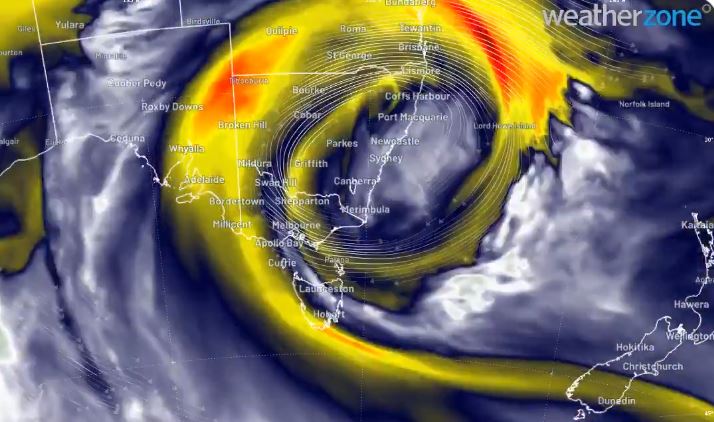
Image: The swirls of yellow show the warm air being dragged south towards Melbourne, while cool air remains entrenched over much of NSW. See further down the story for an animation. Source: Weatherzone.
SHOULD I GO TO THE SNOW THIS WEEKEND?
OUR WRAP OF THE WEEKEND’S LIKELY CONDITIONS HERE
On the snow front, this was quite a cruel weather system for some resorts, with the boundary between cold Antarctic air and warm air from up near the tropics hovering near the NSW/VIC border – but the reverse way you'd expect it, with the cold air north and warm air down south.
- The southern Victorian ski fields of Mt Buller and Mt Baw Baw saw mostly rain ahead of this weekend's official ski season opening.
- The northern Victorian resorts of Falls Creek and Mt Hotham saw a moderate fall of 20-25 cm with a little rain thrown in.
- Meanwhile the major resorts of Perisher and Thredbo in southern NSW received as much as 70 cm of snow, in a dump which will kick off the season in fine style.
We have so much snow we are opening more lifts and terrain on Saturday! Not only will Smiggin Holes make it’s 2021 debut you’ll find; Quad Express to mid-station, Leichhardt Quad Chair, Happy Valley T-Bar and more! Take a peek 👀 👉 https://t.co/rEAT7g4o1d pic.twitter.com/2LVhcwVhKH
— Perisher (@PerisherResort) June 10, 2021
As Weatherzone meteorologist Ben Domensino explained in his story on Thursday:
"Northerly winds usually drag warm air over Sydney from northern NSW or the Tasman Sea. But today, air wrapping around the large cut-off low meant that the air passing over Sydney from the north actually originated near Antarctica.
"This same cut-off low also directed a stream of warmer, moisture-laden air into Victoria on Thursday. So, while Sydney was struggling to reach 10ºC under northerly winds, Melbourne spent much of the day around 14ºC in southerly winds."
The flow of air he's talking about is illustrated really well in this graphic by Weatherzone developer Andrew Miskelly, in which you can clearly see the red and yellow swirls, representing warm air being dragged south.
The cold air mass over south east Australia is becoming "cut off" from the polar flow. Subtropical air wrapping around the system's eastern flank will bring heavy rain to eastern VIC/TAS while the cold air continues on to produce snowfalls over parts of central and northern NSW. pic.twitter.com/4L3xJktdRj
— Andrew Miskelly (@andrewmiskelly) June 8, 2021
As for the weekend, it should be mostly fine in Brisbane, Canberra, Sydney, Adelaide and Darwin, with the chance of showers in Perth and Melbourne, with Hobart the most likely wet spot.
Sydney is our pick of the capitals, with dry days tipped and top temps in the high teens – a richly deserved spell of weather after a very chilly week by local standards.