
Thunderstorms on the cards for southeast Australia once more
It may seem routine now if you’re in southeast Australia, thunderstorms are once again featured in today’s forecasts, as a trough and cold front moves through. The key difference between this one and the many outbreaks over the last few months is that the thunderstorm activity today looks to be less widespread, largely confined to central and southeast New South Wales.
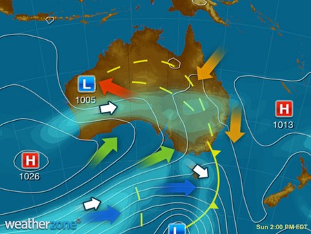
Image: Synoptic chart from 2pm Sun 27th AEDT
Currently, a trough and cold front are moving across eastern Australia. Last night, the trough generated significant thunderstorm activity across South Australia and western Victoria, with a severe thunderstorm warning in place for parts of Western and Central Victoria yesterday afternoon.
Today storms are already flaring up in southeast NSW and eastern Victoria, and are likely to spread further north and east as the afternoon progresses.
Isolated thunderstorms are likely to impact the Sydney region from this afternoon, with thunderstorm activity extending into the Central Slopes and Tablelands, potentially as far west as Hillston, in the NSW Riverina.
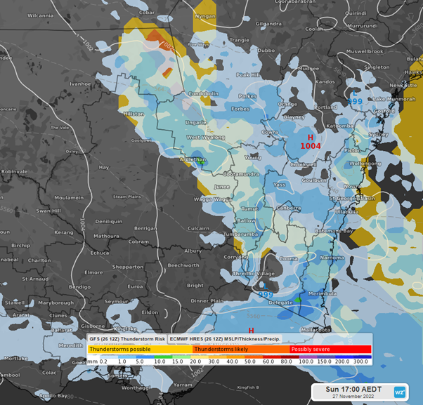
Image: GFS storm risk overlay with 3 hr precipitation at 5pm, Sun 27th AEDT
Later in the evening, as the trough moves further east, thunderstorms should contract towards the Central slopes and tablelands, and to the south and central coasts of NSW – including Greater Sydney.
There remains a risk of thunderstorms again becoming severe during the late afternoon/evening, particularly in the central west and tablelands, with damaging wind gusts and large hail a possibility should those severe storms eventuate.
The cold front will sweep through southern NSW tonight, bringing a gusty southerly change along the coast, but also flushing out the unstable air causing the thunderstorms. Tomorrow, the thunderstorm risk for NSW will likely be confined to the northeast corner as the trough moves towards eastern Queensland.