
Sydney halfway through two-week rainy spell
There's some good news but mostly bad news for Sydney folk who are sick of the relentless rain and desperate to get some washing hung out.
The good news is that Wednesday's showers should stick to the coastal fringe and nearby suburbs, which means if you live in the city's west, it could be a good day to crank up the Hills Hoist.
Overall, however, the picture remains wet, with a continuation of moist onshore winds for at least another week.
The whole Sydney basin has seen steady rain, persistent heavy showers, or at least a few drops on each of the first seven days of May 2024, as the figures below demonstrate.
Sydney Observatory Hill
- May 1: 22.8 mm
- May 2: 23.2 mm
- May 3: 6.8 mm
- May 4: 18.6 mm
- May 5: 21.4 mm
- May 6: 31.2 mm
- May 7: 3.0 mm
Running total 127.0 mm
Penrith
- May 1: 0.2 mm
- May 2: 1.0 mm
- May 3: 0.2 mm
- May 4: 3.6 mm
- May 5: 15.4 mm
- May 6: 10.2 mm
- May 7: 2.4 mm
Running total 33 mm
Note that the city’s "official" weather station at Observatory Hill on the fringe of the CBD has recorded considerably more rain than Penrith in Sydney’s outer west, about 60 km away.
The pattern of heavy rainfall totals near the coast diminishing quickly as you move inland can be seen on the BoM chart below, which shows the weekly NSW rainfall from May 1 to 7.
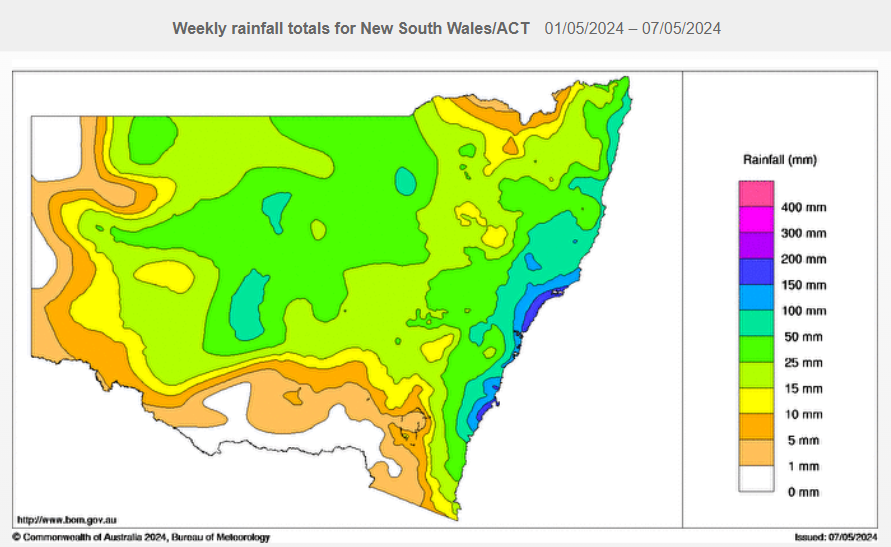
Source: BoM.
But as mentioned, there has still been enough moisture to dampen the ground in most Sydney suburbs every day in May 2024 to date, with the pattern set to continue for another week or so.
Indeed, the likelihood of heavy rain will increase heading into Friday and Saturday.
Why no break in the weather pattern?
Weatherzone meteorologist Ben Domensino wrote a really good explainer on Tuesday about the persistent blocking high pressure systems centred south of the continent which dominated the weather in April. The pattern has continued into May.
While strong highs bring mostly dry conditions to southern SA and Vic, as well as western and southern Tasmania due to a lack of strong cold fronts, persistent onshore winds travelling over the Tasman Sea provide moisture for rain and thunderstorms in eastern NSW and Qld.
Long story short, none of this is set to change dramatically in the next week.
For those who are into records, the ABC reported this week that Sydney's record streak of 1 mm or more of rain recorded at Observatory Hill is 16 consecutive days. That happened in both 1943 and 2022.
The current streak could fall just short of 16 days as signs point towards a drying trend early next week, but we'll keep you updated.