
South Australia, the rains are here
The town that for years held the hottest temperature record for the country is today one of the wettest.
Oodnadatta, famous for the nearby track that traces an ill-fated railway and overland telegraph line, was the official record holder for Australia’s hottest temperature of 50.7ºC until Western Australia's Onslow equaled it last week.
As recently as last weekend, Oodnadatta was doing its typical summer thing of reaching 48 degrees, but from yesterday afternoon to this morning (Saturday 22nd), the typically hot, dry town didn’t manage to reach 30 degrees. It also recorded 40mm of rain, the wettest day since last April. The track is now probably a bog.
The trough responsible for the rain is unusually slow moving, and remarkably moisture-laden with tropical infeed from across the north. Today, the rain focus will shift only slightly eastwards, to the Maree/Lake Eyre region, encompassing the southern part of the Oodnadatta track. Totals in the surrounding areas are likely to exceed 30mm once more, with isolated falls of 50-100mm possible with storms embedded in the rain band. The rain band extends all the way to the coast, over the Flinders Ranges, Eyre and Yorke Peninsulas where similar totals are expected on Saturday.
On Sunday, the band will again shift only slowly east, starting to affect the Adelaide region, though totals for the city should remain lower, at 15-30mm. This would still make it the wettest day since October.
With the persistence of cloudy, rainy conditions, Oodnadatta is again only forecasting a cool day on Saturday - 31 degrees - which would make it the coolest two day period in January since 2016.
Rain will start to spend itself out over South Australia on Monday, before regathering steam over Victoria and New South Wales mid-week as it collides with moisture from the Tasman Sea.
The weather patterns this summer have been remarkably persistent, anchoring high pressure systems southeast of the country which have then driven persistent cloud and showers over the east, and baking heat picked up from interior over the west. While it's impossible to predict day to day synoptic patterns more than a couple of weeks ahead, the patterns this summer are consistent with the La Niña and positive Southern Annular Mode (SAM) conditions that have dominated the summer. Both climate drivers, in these phases, tend to result in predominant easterly winds over the east of the country.
There are early signs La Niña has peaked, with a decay back to more neutral conditions forecast for late summer and early autumn. Hopefully, this will mix up the weather, giving some dry heat to the east and rainy cool to the west. But not this week or next, by the looks of it.
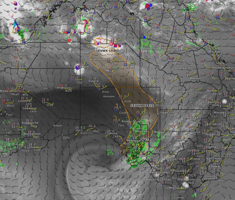
Image: Water vapour imagery overlaid with above surface winds from the EC model, showing tropical moisture feeding into the trough over South Australia. The orange dotted line is the area bounding the Severe Weather Warning for the system, current at 10am EDT Saturday 22nd. See https://www.weatherzone.com.au/warnings or http://www.bom.gov.au/sa/warnings/ for up-to-date warnings.