
Some say La Nina is already here
While Australia's Bureau of Meteorology says that there is a 70 percent chance of La Niña developing later this year, the U.S. Climate Prediction Centre has come out and told us that La Niña is already here.
So, what's going on?
To understand why we are getting mixed signals from the official US and Australian climate monitoring agencies, we first need to look at what La Niña is.
The term La Niña refers to a pattern of abnormal sea surface temperatures and associated atmospheric conditions across the equatorial Pacific Ocean.
During La Niña, we see abnormally cool water sitting near the equator of the central and eastern Pacific Ocean, and warmer-than-average water in the western side of the equatorial Pacific Ocean.
You can see this distinctive La Niña pattern in the image below, which shows Pacific Ocean sea surface temperature anomalies earlier this week.
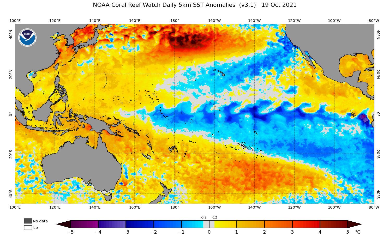
Image: Sea surface temperautre anomalies in the Pacific Ocean on October 19, 2021. Source: NOAA
When these ocean temperature anomalies develop across the Pacific Ocean, it triggers a response in the atmosphere that can affect weather patterns on a global scale.
In Australia, La Niña typically causes:
- Above-average rain
- Cooler-than-usual days
- More tropical cyclones
- Higher chance of flooding
- Less bushfires
- Less extremely hot days
- More prolonged heatwaves
The disagreement about whether or not a La Niña is currently underway comes down to how it is measured.
For La Niña to be declared by Australia's Bureau of Meteorology, any three of the following four thresholds need to be met:
- Sea surface temperatures in the central and eastern equatorial Pacific Ocean (NINO3 or NINO3.4 regions) are 0.8ºC cooler than average.
- Trade winds have been stronger than average in the western or central equatorial Pacific Ocean during any three of the last four months.
- The three-month average Southern Oscillation Index (a measure of the mean sea level pressure difference between Tahiti and Darwin) is +7 or higher.
- A majority of surveyed climate models show sustained cooling to at least 0.8ºC below average in the NINO3 or NINO3.4 regions of the Pacific until the end of the year.
America's thresholds of La Niña are a bit easier to reach than those used in Australia, and they lean more heavily on what is expected to happen in the future. According to the U.S. Climate Prediction Centre (CPC), La Niña conditions exist when:
- Sea surface temperatures in the eastern equatorial Pacific (NINO3.4 region) are 0.5ºC cooler than usual, averaged over one month.
- There is an expectation that the sea surface temperature in the NINO-3.4 region will stay below 0.5C below average for at least three consecutive months.
- The atmosphere is showing signs of responding to the ocean cooling, such as a strengthening of the trade winds that transport moisture towards Australia.
It's common for the U.S. to call the start of La Niña or El Niño before Australia does, due to these differences.
While there have been some years where the U.S. thresholds are met but Australia's aren't, that isn't likely to be the case this year. It's more likely than not that the Bureau of Meteorology will soon be declaring La Niña as well.