
Port Macquarie recovering from intense storm
A wild thunderstorm hit Port Macquarie on the NSW Mid North Coast just before 3pm Friday afternoon. The storm reportedly lasted for 10 to 20 minutes with damaging winds and small hail observed across most of the city.
Extensive damage occurred with trees, and power poles down and roofs blown off buildings. The main CBD and properties along Hastings River Drive and Settlement Point were some of the hardest hit areas. Thankfully there have been no reports of significant injuries.
Yikes, Clarence Street has seen better days. This from my dad after a violent storm swept through Port Macquarie this afternoon. pic.twitter.com/jX7U0rNwSX
— Brooke Wylie (@brookewylie) February 3, 2023
The thunderstorm was triggered by a trough crossing the region and interacting with warm, moist unstable air. Only a few cells formed in the area with the main cell hitting Port Macquarie.
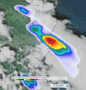
Figure 1: Satellite and radar image of a single cell thunderstorm over Port Macquarie on Friday 3rd February 2023.
Port Macquarie Airport AWS recorded 13.2mm of rainfall in 40 min and a maximum wind gust of 57km/h at 2:45pm and again at 2:53pm. This would not have represented the most intense gusts of the storm with winds potentially reaching in excess of 110km/h.
Port Macquarie this afternoon. It looks like a war zone after being smashed by a storm. Lucky no one was killed. The damage however is a different story.
— Kate🦋M© (@Kate3015) February 3, 2023
Thank heavens a few K’s south where I am just thunder & a few spots of rain. ðŸ™�ðŸ�»ðŸ™�ðŸ�» pic.twitter.com/tHVvuTAwAT
Organisers of the Red Hot Summer Tour have canceled Saturday's event as the storm caused severe damage to the stage and infrastructure.
Thankfully conditions are calmer today as a ridge of high pressure brings more stable conditions to the area.