
Perth's brief wet, the first rain in weeks
The Perth area and surrounds had not recorded any rainfall in the past five-to-seven weeks but yesterday it finally arrived.
Unfortunately, it mostly came down in meager quantities despite the dark, tall clouds. Thunderstorms in the Perth area and to its north yesterday promised to deliver what the city and surrounds desperately need, proper rain, but they ended up only bringing less than about 10mm to most areas. Some of it was lost down the cracks in the ground.
It was the first rain recorded in:
- 12 weeks at Rottnest Island (just 0.2mm)
- Seven weeks at Swanbourne (1.0mm)
- Six weeks at Arena (0.8mm), Jurien Bay (4.6mm), Geraldton (0.6mm), Coolangatta (14mm), Badgingarra (4mm), and Gingin
- Five weeks in Perth’s Mt Lawley (1.2mm), Jandakot (9.2mm), Jarrahdale (3.8mm), Pearce (11.2mm), Bickley (4.0mm) and Anketell (10.3mm)
There has been so little rain so far this year, yesterday's rain and storms brought the biggest falls in:
- Eight months to Mt Magnet (5.8mm), Jurien Bay, Pearce, Lancelin (3.2mm), Gingin, Jandakot and Anketell
- Six months to Serpentine (3.6mm)
- Five months to Jarrahdale, Bungendore (1.2mm) and Pinjarra South (2.0mm)
This rainfall was hit-and-miss, typical of thunderstorms, and has done little to boost dams and green gardens and parks. Perth's total water storage is still only 40.9% capacity which is down from 50.1% at this time last year. In some northern suburbs, the storms did bring some brief flash flooding, mainly flat areas where drains and gutters had been blocked.
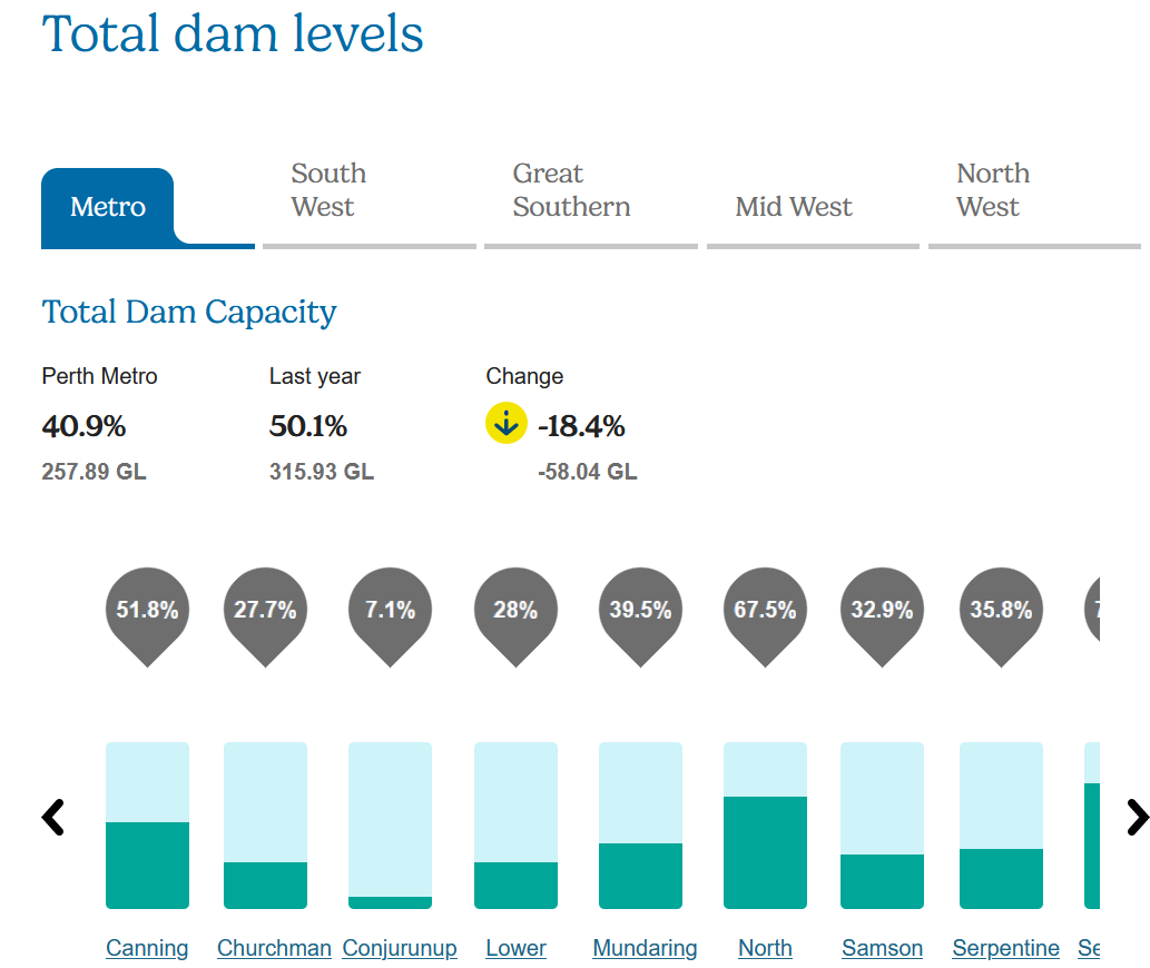
Image: Latest dam levels in the Perth area, courtesy of Water Corporation
Looking ahead, there are no signs of useful rain in the next fortnight due to a high-pressure area likely spending almost all of that time centred south of Western Australia, forcing fronts well to the south.
As a result, winds blowing around that high will be persistently dry easterly and become gusty and very warm, leading to continued evaporation.
Hopefully, the weather pattern changes enough, and rain arrives by the end of the month.