
How much rain will Ex-Tropical Cyclone Imogen bring North Queensland?
The first Australian-named tropical cyclone crossed the southwest Gulf of Carpentaria coast on Sunday evening, and is going to deliver big rain to parts of tropical Queensland.
Now an ex-tropical cyclone, the remnants of Tropical Cyclone Imogen is currently moving in an east-southeast direction over the Gulf Country and Northern Goldfields districts, with an associated monsoon trough over the northeast coast. In the 24 hours to 9am Monday, Cardwell had received 436mm of rain, Kowanyama 345mm, Burketown Airport 245mm, and further east, Ayr had collected 210mm.
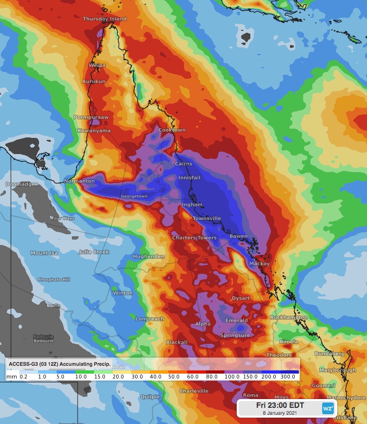 Image: accumulated rainfall from today until Friday evening, using the ACCESS-G3 model.
This is only the start, as the tropical low is likely to hang around for the next few days as it weakens. By the end of the working week, southern parts of the Peninsula, North Tropical Coast and Tablelands, Herbert and Lower Burdekin, Northern Goldfields and Upper Flinders, and even coastal parts of Central Coast, could see well over 250-300mm. Fortunately Gulf Country may have seen its heaviest rain, as most models are showing the heaviest falls in eastern and central parts of tropical Queensland.
Riverine flooding is likely over a large area, possibly drawing large reptiles to areas they are not usually found in. So it’s advised to take extra precautions anywhere near any floodwaters.