
Australia's wettest November on record
Australia just had its wettest November in 122 years of records as the 'perfect storm' of climate drivers aligned to deliver copious rainfall across the country.
The map below shows that the vast majority of Australia received above-average rain last month (blue shading), with quite a few areas experiencing their wettest November on record (dark blue).
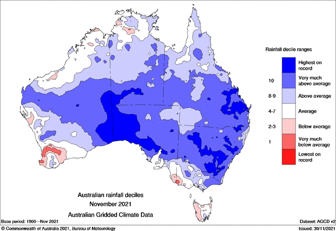
Image: Observed rainfall deciles in Australia during November 2021. Source: Bureau of Meteorology
For Australia as a whole, it was the wettest November on record, with observations available since 1900. Some states also had a very wet month:
- NSW/ACT – wettest November on record
- SA – wettest November on record
- VIC – wettest November in 10 years
- QLD – wettest November in 11 years
- NT – wettest November in 4 years
- WA – wettest November in 9 years
- TAS – wettest November in 2 years
It was also Australia's coolest November in 22 years based on the national mean temperature. However, despite being cooler-than-average, no state or territory had their coolest November on record.

Image: Observed mean temperature deciles in Australia during November 2021. Source: Bureau of Meteorology
The prolific November rain and relatively cool temperatures were caused by a combination of broad-scale climate drivers that helped drive moisture-laden air over Australia, providing fuel for regular and heavy rainfall.
In the Pacific Ocean, a La Niña pattern caused trade winds to strengthen near the equator and transport humid air towards Australia.
This flow of atmospheric moisture over eastern Australia was further enhanced by a persistently positive phase of the Southern Annular Mode (SAM) throughout November.
In the Indian Ocean, a decaying negative Indian Ocean Dipole (IOD) meant there was also an increased amount of moisture flowing towards Australia from the northwest during November.
On top of these three climate drivers, a moderately strong pulse of the Madden-Julian Oscillation (MJO) enhanced the development of clouds and rainfall to the north of Australia during the second half of the month. Some of this moisture travelled across the Australian continent and caused flooding rain.
It's rare to see all four of these broad-scale climate influencers aligning within the same month, which is why some areas of Australia just saw their wettest November on record.
One local rainfall statistic is also worth pointing out. The NSW town of Bathurst collected just over 240mm of rain last month. This is the town's wettest calendar month in records dating back to 1858.
With so much rain falling across the country in November, December has started with flooded rivers, overflowing dams and saturated catchments in multiple states. This waterlogged landscape is likely to cause more flooding when heavy rain hits this summer.