
What is the rare "atmospheric river" hitting Antarctica?
Did you ever wonder where Tropical Cyclone Seroja went after racing off Australia's south coast on Monday?
Much like its jostle with Tropical Cyclone Odette to the northwest of Australia late last week, which Seroja undeniably won, the remnants of Seroja encountered another low pressure system as it darted over the Southern Ocean on Monday.
Unfortunately, this interaction didn't go so well for the former tropical cyclone, with the stronger extra-tropical low absorbing Seroja's remnants before continuing its journey across the Southern Ocean.
However unlike most mid-latitude low pressure systems that travel from west to east between Australia and Antarctica, this system is bound for the icy continent itself.
An atmospheric 'ridge' to the east of New Zealand will cause the low to race towards the south and slam into the Antarctic coastline on Friday, in a region of East Antarctica known as Victoria Land.
Along with a burst of violent winds, this landfalling low pressure system will be accompanied by an 'atmospheric river' that will produce several days of heavy snow.
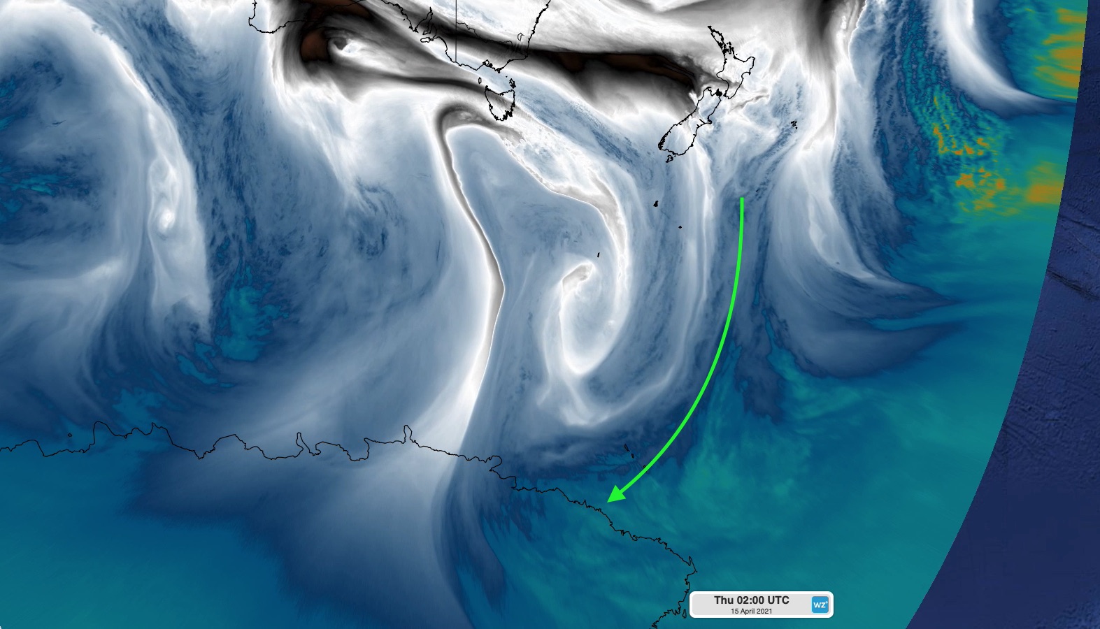
Image: Enhanced water vapour satellite image showing an atmospheric river (green arrow) transporting mositure-laden air towards Antarctica on the eastern side of a low pressure system.
Atmospheric rivers are concentrated streams of airborne moisture that transport large amounts of water vapour through the sky. They occur in many parts of the world and often result in heavy rain or snow when they pass over land.
In this case, an atmospheric river flowing from north to south is making a rare landfall in Antarctica. This only happens a few times each year in any given region along the Antarctic coastline.
This unusual weather event has caught the attention of Jonathan Wille, a postdoctoral researcher specialising in Antarctic meteorology at the University Grenoble Alpes in France.
"This will be a very heavy snow and wind producing event likely leading to some very high snowfall accumulations," he told Weatherzone.
Atmospheric river-driven snowfalls are at the forefront of polar research, as scientists scramble to figure out how they might change the mass balance of Antarctica in our warming world.
While they only happen a few times per year in coastal Antarctic locations, newly published research from Jonathan Wille and colleagues shows that atmospheric rivers are responsible for 10-20 percent of the total annual snowfall in East Antarctica.
In today's climate, Jonathan Wille says that "atmospheric rivers are a positive for the Antarctic mass balance."
This is because, on average, there is more snow gain than snow loss from atmospheric rivers reaching Antarctica.
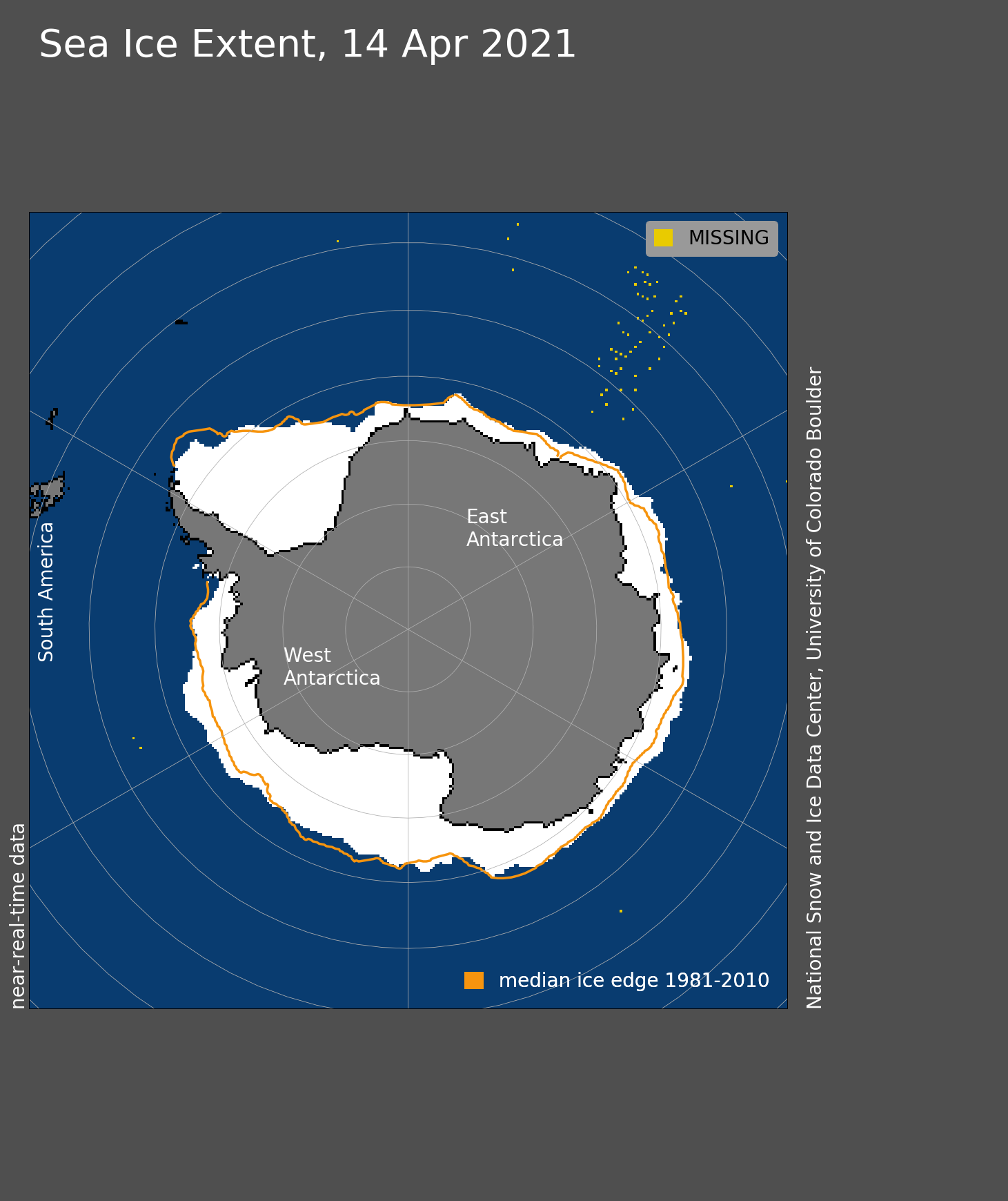
Image: Sea ice extent around Antarctica is currently above the long-term average for this time of year and the highest since 2016 for the same date in April. In this image, white represents the current (April 14) sea ice extent and the yellow line is the long-term (1981 to 2010) average extent for the same date. Source: National Snow and Ice Data Centre, University of Colorado Boulder
However, Dr Wille points out that the future influence of atmospheric rivers on Antarctica's mass balance, and the resulting contribution to global sea level rise, may be less beneficial.
"Most climate models indicate that globally atmospheric rivers may become more intense in the future as a warming climate is capable of holding more water.
"But as the climate warms, atmospheric rivers could turn from a net positive to net negative for the Antarctic mass balance.
"The balance between melt and snow may get tilted in the melt direction.
"Ice shelves on the Antarctic Peninsula could become more susceptible to atmospheric river-related melting if the climate warms putting them at a greater risk of collapse," he said.
While this is still very much an active area of research, Dr Wille says that 3-4ºC of warming above pre-industrial levels is thought to be the threshold for melting to start outpacing snow gain from atmospheric rivers in Antarctica.
For now, weather systems like the one we are witnessing this week are helping to keep snow and ice locked up in Antarctica and mitigate sea level rise.
But it's not good news for everyone involved. "I imagine the local penguins won't be very happy about this," Dr Wille concluded.