
West coast communities need to prepare for Seroja
There are growing concerns that Tropical Cyclone Seroja could become Western Australia's first landfalling tropical cyclone of the season, with models firming up the chances of a coastal crossing along the state's west coast in about three days' time.
On Thursday morning, Tropical Cyclone Seroja and another Tropical Low were both spinning over open waters to the northwest of Australia. Japan's Himawari-8 satellite captured spectacular images of the twin tropical systems spinning in relatively close proximity as the sun rose on Thursday.
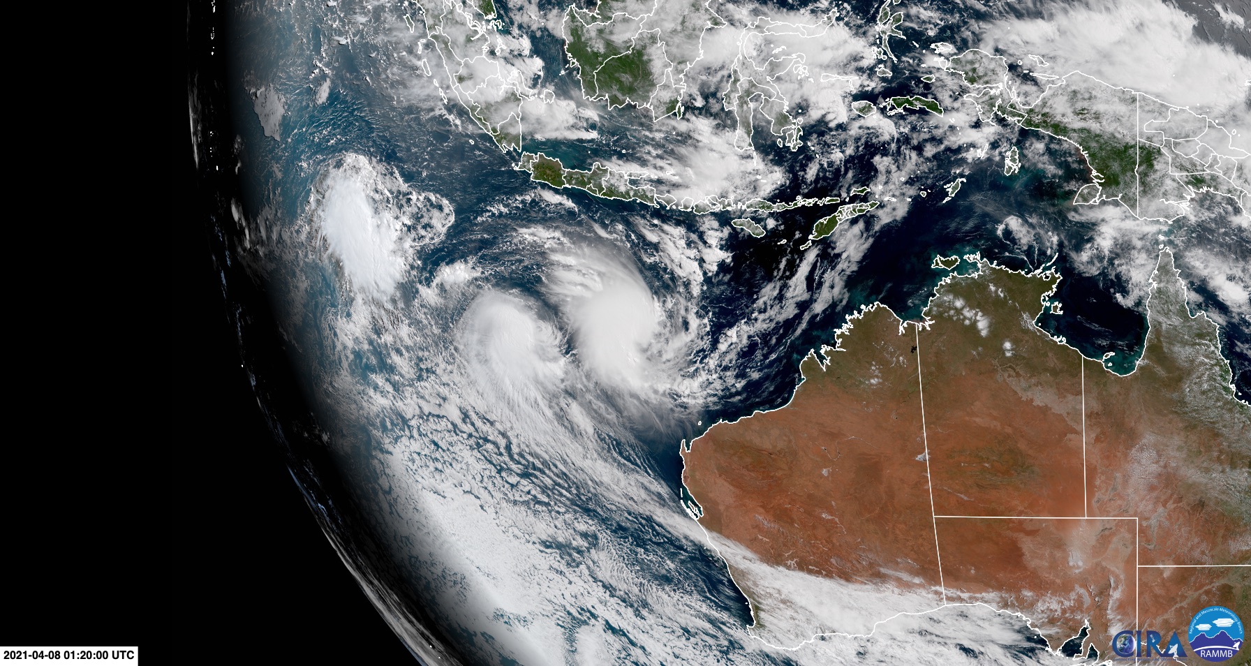
Image: Tropical Cyclone Seroja and a nearby Tropical Low to the northwest of Australia on Thursday morning, captured by Japan's Himiwari-8 satellite. Source: RAMMB/CIRA
As of 8am WST on Thursday, Seroja was a category one tropical cyclone located just over 600 km off Western Australia's Pilbara coastline, with sustained 10-minute wind speeds of around 75 km/h around its core.
At that time the Tropical Low was located, another 740 km to Seroja's west, with similar wind speeds detected in a small area to the southwest of its centre. However, because these gale force winds were only present in one of the low's four quadrants, it hasn't yet been classified as a tropical cyclone. For this to happen, gales need to extend at least half way around the centre of the low.
Looking ahead, Seroja and the Tropical Low are expected to drift closer together during the next 24 hours, with the low possibly becoming a low-end tropical cyclone for a brief period on Friday.
As the two systems move closer together and their wind fields interact, they will start to orbit each other due to a phenomenon called the Fujiwhara effect. The outcome of this interaction should see the Tropical Low weaken and become absorbed into Seroja's circulation over the weekend, before Seroja starts moving towards the south from Sunday.
While the Fujiwhara interaction should take place several hundred kilometres away from Western Australia, there could still be an increase in wind and rain in the Exmouth region on the weekend as the decaying low gets swung around by Seroja.
But this probably won't be the worst of the weather these systems bring to Western Australia.
While there is still some uncertainty regarding Tropical Cyclone Seroja's path following the Fujiwhara interaction, it's looking increasingly likely that it will make a beeline for the west coast of Western Australia.
Most forecast models suggest that Seroja will make landfall somewhere between about Shark Bay and Jurien Bay on Sunday night or Monday morning. However, the Bureau of Meteorology's latest track map, issued at 9am WST on Thursday, suggests that Seroja's centre could hit the coast anywhere between about Carnarvon and Mandurah. At landfall, Seroja could still be a category two or three tropical cyclone, although this is still very much up in the air.
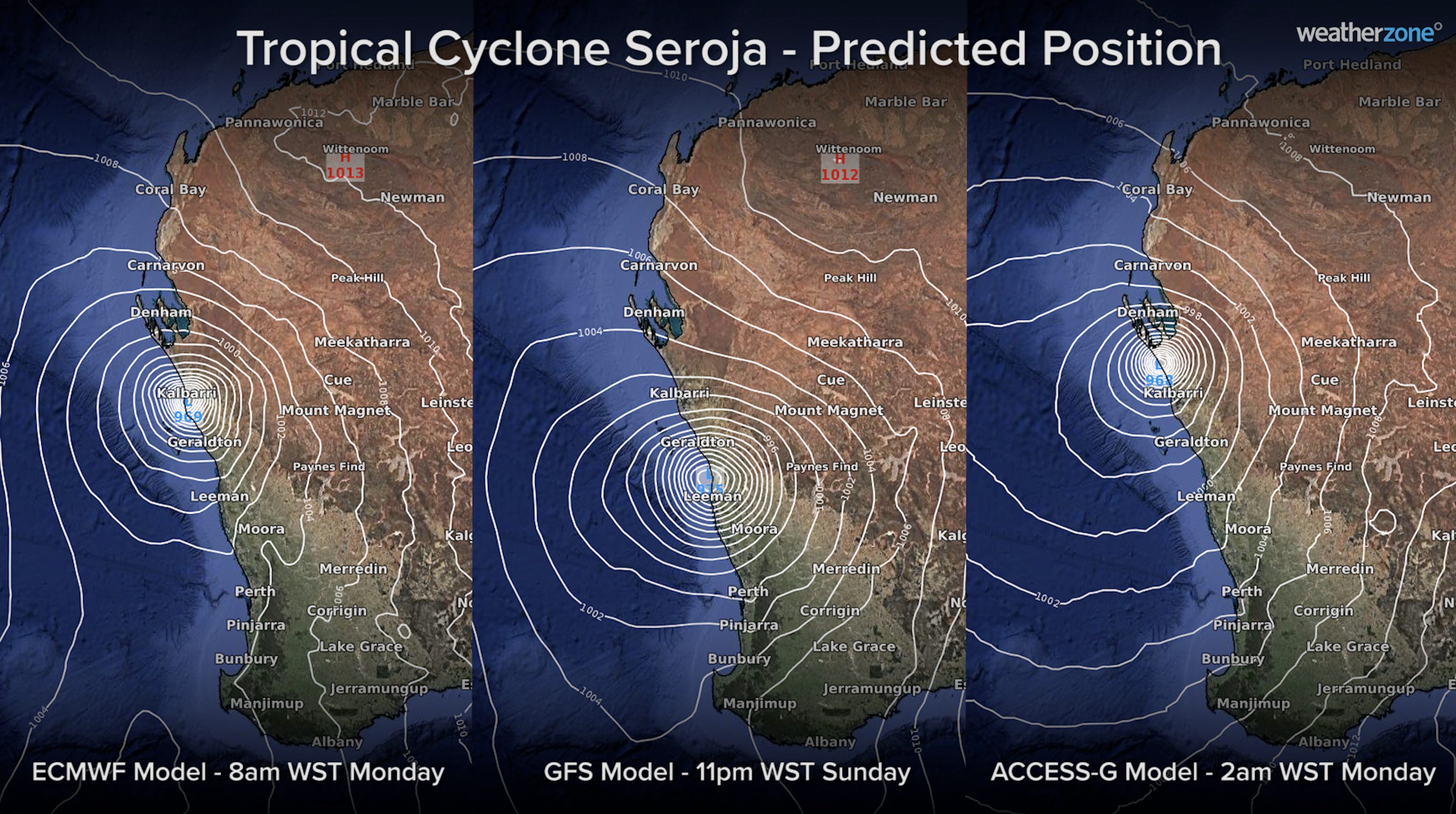
Image: Forecast position of Tropical Cyclone Seroja at landfall according to three different forecast models. These forecasts may change in the coming days.
The uncertainty around Seroja's future movement and strength open up a broad area of Western Australia to the possibility of severe weather from this weekend into early next week.
Be sure to keep up to date with the latest tropical cyclone track maps and weather warnings during the next several days if you live in Western Australia.