
Welcome rain arrives before early-season cold snap in southeastern Australia
A significant autumn rain event is unfolding across parts southern and southeastern Australia, with a burst of cold weather looming on the horizon.
A large mass of frigid air from the Southern Ocean is interacting with warmer, moisture-laden air over Australia this week, causing a dynamic mix of weather in multiple states and territories.
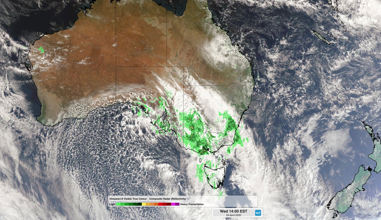
Image: Combined satellite and radar image from Wednesday afternoon, showing thick rain-bearing clouds over southeastern Australia ahead of cold-air speckled cloud in the Great Australian Bight.
At the leading edge of this wintry weather system, a broad band of cloud and showers spread across southern and southeastern Australia on Tuesday and Wednesday.
During the 24 hours to 9am on Wednesday, widespread falls of 10-20mm were recorded in parts of South Australia, Victoria and southern NSW. The heaviest rain fell in the mainland alps, where Thredbo picked up 80mm and Falls Creek topped the table with 97mm. South Australia's heaviest fall was 30mm at Ashton in the Adelaide Hills.
In addition to the rain, powerful winds also lashed the high mountains in southeastern Australia on Wednesday. Gusts reached 128km/h at Thredbo Top Station and 107km/h at Mount Hotham early in the morning, with more damaging winds expected in these alpine regions later in the day.
Blustery winds on Wednesday afternoon also whipped up dust in the eastern inland of South Australia and far western NSW. The dust could be seen sweeping over Broken Hill as thunderstorms loomed on the horizon.
Broken Hill getting battered by a howling midday dust storm! Managed to snap this pic before my new white shirt was turned light brown! @SpencerGulfNN #duststorm pic.twitter.com/5DncGIEQ7k
— Patrick Reincke (@PatrickReincke) April 29, 2020
Rain and isolated thunderstorms will continue to affect parts of Tasmania, Victoria, NSW and the ACT on Wednesday, before spreading further north through NSW and southern Queensland on Thursday.
This system will bring useful rain to a large area of the drought-weary Murray Darling Basin. But while this week's rain will be welcome in the parched landscape, flooding is a concern in the immediate future for some areas. Flood watches have been issued in parts of Victoria and NSW.
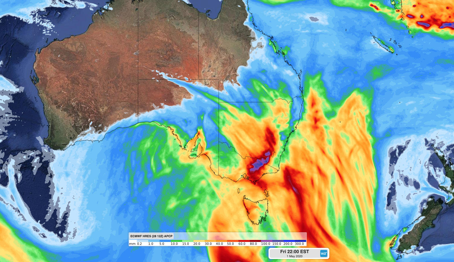
Image: Forecast accumulated rain between Wednesday and Friday according to the ECMWF-HRES model.
The initial band of rain will clear off Australia's east coast on Friday, although showers and much cooler air will linger over parts of southern and southeastern Australia in its wake, through to the weekend. Some of these showers will fall as snow in high terrain from Tasmania up to the central inland of NSW. The cold air could also bring some of the lowest maximum temperatures seen this early in autumn for decades.