
The link between tropical cyclones and heatwaves
A severe-to-extreme heatwave is about to send temperatures soaring across southeastern Australia. At the same time, northwestern Australia is bracing for a landfalling tropical cyclone.
While these two extreme weather events are playing out thousands of kilometres apart, it's no coincidence that they are happening within days of each other.
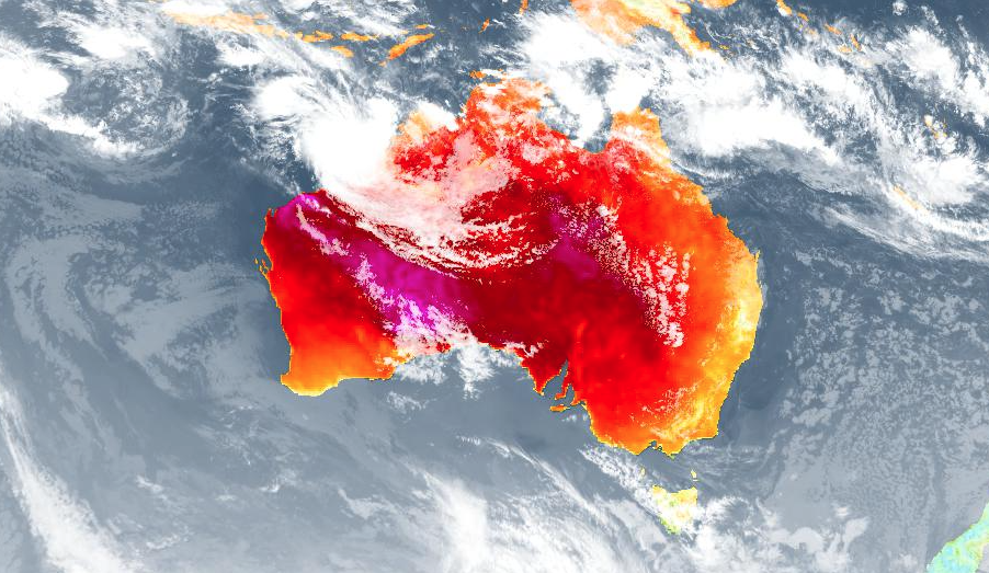
Image: Combined satellite and modelled surface temperature on Thursday afternoon.
-- Lessons from our past --
The last week of January in 2009 was a busy time for weather forecasters in Australia.
Tropical Cyclone Dominic crossed Western Australia's Pilbara coast as a category two cyclone on January 27. Dominic caused minor structural damage as it made landfall and went on to cause flooding in some southern parts of the state.
This landfalling cyclone was immediately followed by an exceptional heatwave in southeastern Australia during late January and early February. This heatwave, which preceded the Black Saturday bushfires, caused rolling blackouts and was associated with 374 excess deaths in Victoria.
While these two events were noteworthy on their own, Australian researchers discovered that tropical cyclone Dominic actually exacerbated the deadly heatwave that followed in southeastern Australia.
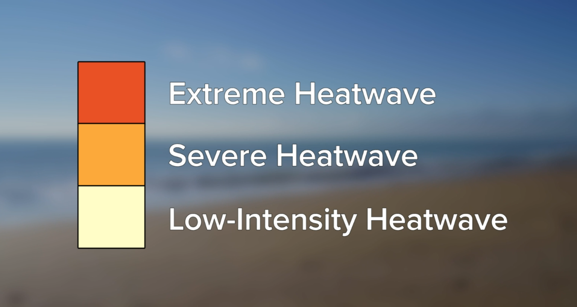
Image: Australia uses a three-tiered scale for measuing heatwaves. Severe heatwaves can be challenging for vulnerable members of the community. Extreme heatwaves can be problematic for anyone who is not taking steps to stay cool, especially people working or exercising outdoors.
Dr. Tess Parker is a research fellow at Monash University, and an Associate Investigator in the heatwaves research program at the ARC Centre of Excellence for Climate Extremes. She led the study that linked tropical cyclones to heatwaves in Australia during her PhD.
"Heatwaves in southeastern Australia are associated with slow-moving surface high pressure systems," she told Weatherzone. "These highs stall over the Tasman Sea for several days, increasing surface temperatures over the land."
Dr. Parker explained that air flowing away from northwestern Australia's tropical cyclones, in the upper-levels of the atmosphere, can influence southeastern Australia's heatwaves in two ways.
The first is by interacting with the jetstream that flows around 10 km above the ground near southern Australia. The second is by directly aiding the rotation of large upper-level high pressure systems, which are called anticyclones, over the Tasman Sea.
"Through either or both of these processes, tropical cyclones over the northwest of Australia may reinforce the upper-level anticyclone, and thereby lead to persistence of the slow-moving surface high pressure system that is commonly associated with heatwaves in the southeast of Australia," Dr Parker said.
-- Then and now --
This week's weather pattern is similar to the one that produced the 2009 heatwave, with a tropical cyclone forming to the northwest of Australia and a region of high pressure forming and lingering above the Tasman Sea.
"It is certainly possible that the forecast tropical cyclone may influence the development of the heatwave predicted for this weekend," Dr Parker said. "The conditions are very similar to previous events."
However, the impending heatwave is not likely to be quite as hot as the 2009 event, simply because the air mass being driven over southeastern Australia is a bit cooler this time around.
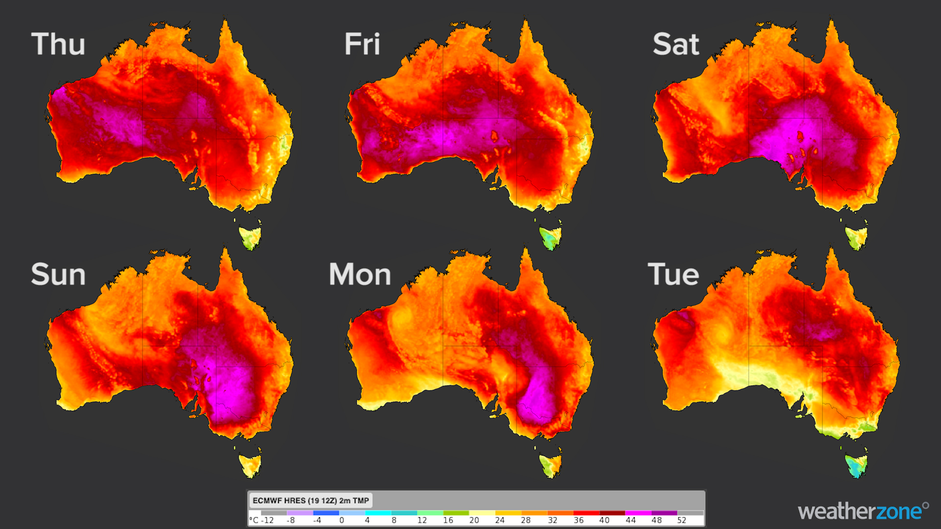
Image: Forecast surface temperatures at 4pm AEST each day between today and next Tuesday, according to the ECMWF model.
A number of records were broken during the 2009 heatwave. Tasmania set a new state maximum temperature record two days in a row, while January 30 was the hottest day ever recorded for nearly half of the state's weather stations. These figures aren't likely to be challenged during this heatwave.
In late January and early February 2009, temperatures also reached as high as 48.8ºC in Victoria 48.2ºC in South Australia. The mercury is only forecast to reach up to 45ºC in both states during the next week.
But heatwaves don't have to break records to be dangerous and they have caused more deaths in Australia than all other natural hazards combined. Make sure you take steps to keep cool in southeastern Australia between now and Australia Day, and if you live in northwestern Australia, keep an eye on the latest cyclone warnings.