
Surf prospect for eastern Australia generated by the coming coastal low
A coastal low will deepen over the Tasman Sea on Monday bringing an extended run of higher energy surf to much of the east coast of Australia.
While it may be a beautiful sunny day today, with playful 1-2ft surf from the east, along with light winds across most of Sydney, the Mid North Coast and the Gold Coast, conditions will change rapidly over the coming days. Clouds and showers associated with a low pressure trough will push over later today, and this trough will evolve into a large swell generating system off the coast of NSW.
Swell size will rapidly inflate over in Sydney and surrounding coasts into the 4.5-5.5m range on Tuesday, and remain large until late Thursday. Conditions will be wet and very windy with persistent southerly winds. The large surf and wind direction will promote surfing at protected southern corners and points, which should still carry plenty of energy as waves refract around headlands and reefs. Exposed spots should have no difficulty reaching 8-10ft or more, these options will be dangerous and only for the experienced and knowledgeable madmen.
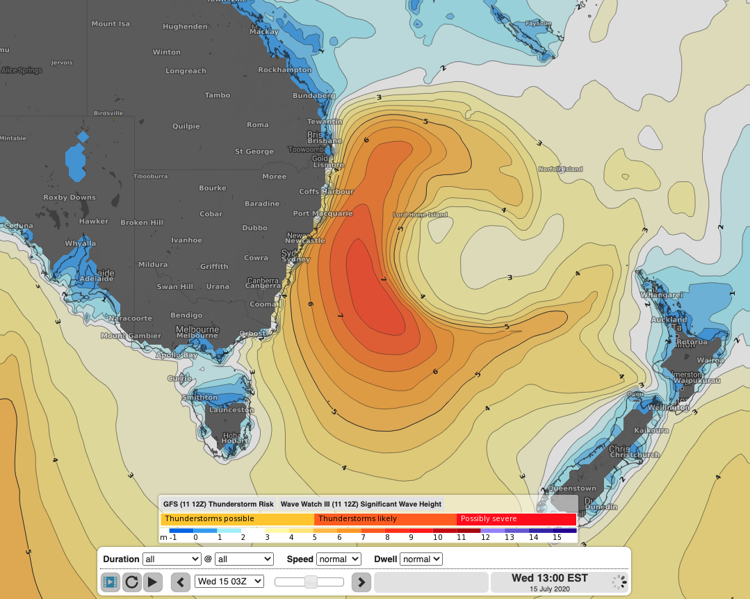
WaveWatch III model run of significant wave height showing a very large swell, reaching 8m, generated by a Tasman Low off the NSW coast on Wednesday
Further north, southeast Queensland and the Northern Rivers in NSW will see this rapid increase in wave height delayed until late Tuesday afternoon as winds circle around this low and up the coast of NSW. With a longer area of strong winds blowing over the ocean, swell height looks to just exceed the 4.5-5.5m range, reaching towards 6m at times. This large swell will persist until Friday morning and then gradually ease. This significant southerly swell with winds from the southwest or south over this period will bring excellent surf to the many points of the Gold Coast, Tweed and Byron areas.
With the first half of this swell favouring hiding behind large landmasses away from the grunt of the swell and the wind, the tail end of this event looks a lot juicier and more inviting. As this low continues its track eastwards, a renewed fetch of E/SE wind directed towards our coastline will form just west of New Zealand. As a result, we should see the run of swell continue well into the weekend, only dying off early the following week. Much of the East Coast should see 2-3m waves from the ESE/SE direction with much more favourable winds going into next weekend.
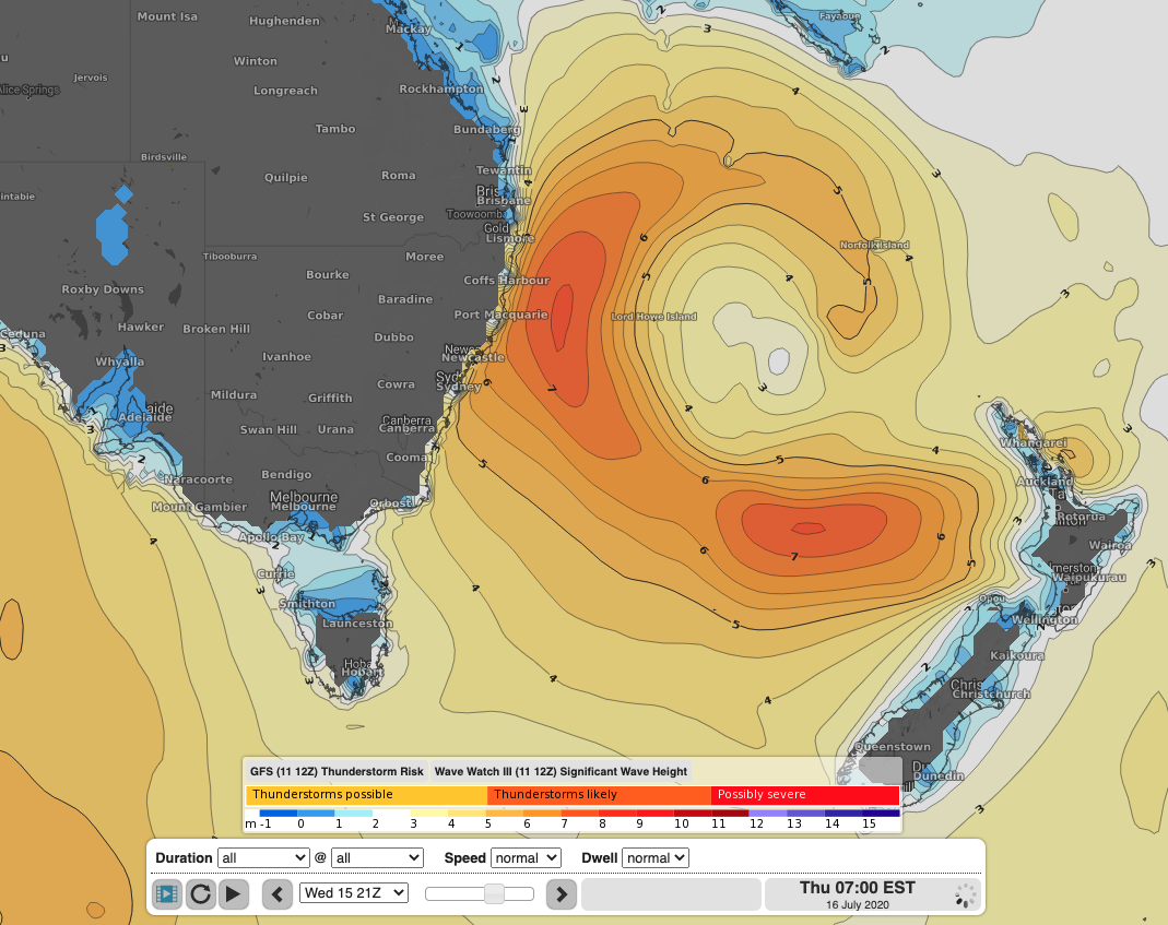
WaveWatch III model of significant wave height showing the large swell generated by an extensive fetch of E/SE winds between New Zealand and Australia. This swell will be smaller in size when it reaches our coast, but should provide more manageable surf for experienced boardriders
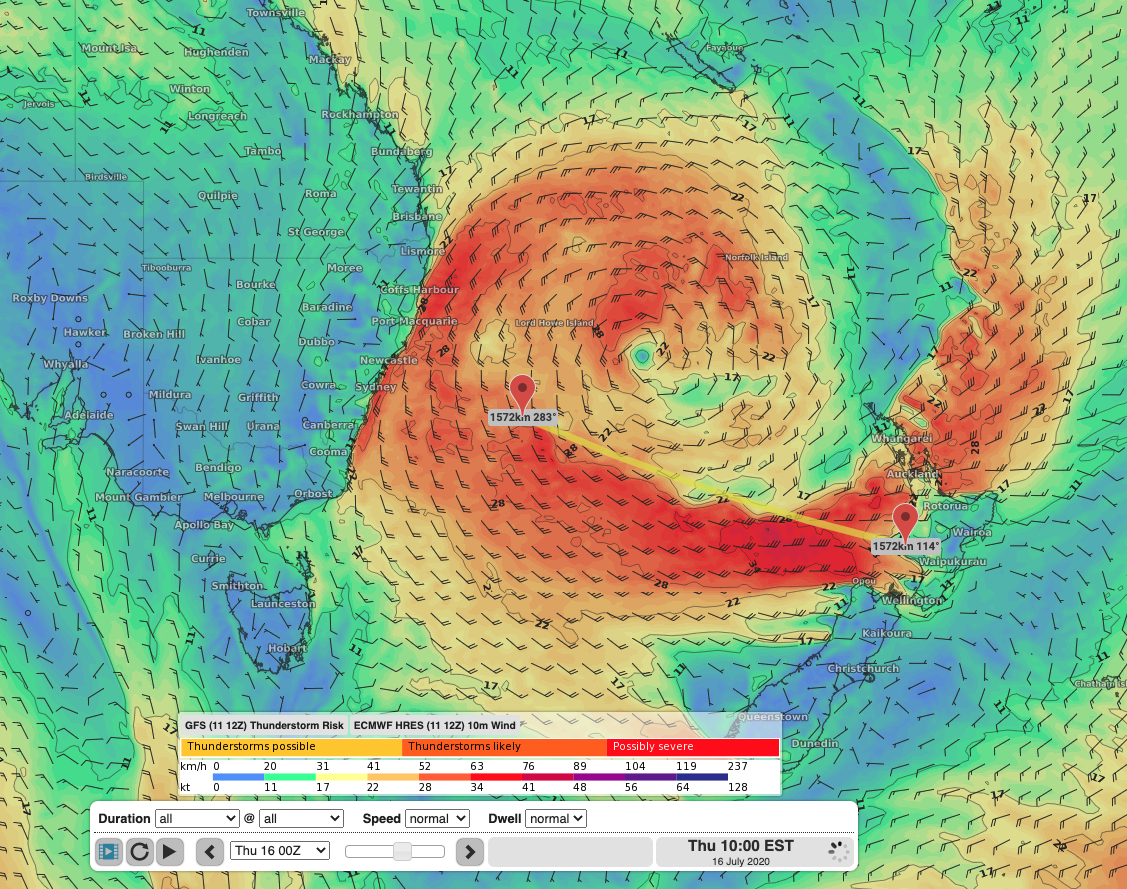
GFS model run of 10m wind showing a broad area of E/SE wind stretching about 1500km from the New Zealand towards Australia which will bring a renewal in swell energy later in the week
With very large waves expected this week, and still substantial surf lingering well into next weekend, it is important for any surfriders, boaters, rock fishermen and beach goers to properly assess conditions before heading out. Keep an eye out for weather and marine warnings at: https://www.weatherzone.com.au/warnings.jsp