
More rain could be on the horizon for NSW
Despite still being on the doorstep of what's looking likely to be our next La Niña episode, parts of NSW have already seen more rain this year than the last two years combined.
Both the ocean and atmosphere in the tropical Pacific Ocean region are currently displaying a typical La Niña-like pattern. Most forecast models predict that this pattern will persist in the coming months, meaning La Niña is more likely than not during the second half of 2020. The Bureau of Meteorology currently rates the likelihood of La Niña occurring in 2020 at 70 percent.
.jpg)
La Niña typically causes above-average rain over large areas of northern and eastern Australia during spring. In some parts of northern and eastern Australia, La Niña is also associated with above-average summer rain.
In NSW, above-average rainfall in the months ahead would continue an impressive turnaround from the remarkably dry three-year period that gripped the state between 2017 and 2019.
This year has already been much wetter than the last few years for much of NSW. The state as a whole just had its wettest winter and August since 2016, following its wettest autumn and February since 2012.
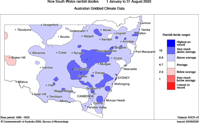
Image: Rainfall deciles during the first eight months of 2020. Source: Bureau of Meteorology
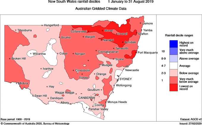
Image: Rainfall deciles during the first eight months of 2019. Source: Bureau of Meteorology
In western NSW, Condobolin received 526.8mm of rain during the first eight months of this year. This is more rain than they saw during all of 2018 and 2019 combined (379.4mm).
Sydney is also having a much wetter year than the last few. At the end of August, the city's running year-to-date total of 1140.2mm was more rain than Sydney saw during all of 2019, 2018 and 2017. Impressively, Sydney's rain so far in 2020 is more than Melbourne has seen during any full year in records dating back to 1856.
If La Niña does ramp up in the coming months, the rest of 2020 should continue to look very different to the last few years in NSW. There is potential that the focus in the coming months will be on floods more than fires in some parts of the state.