
Hard call on rainfall in eastern NSW

Heavy rain and thunderstorms will affect some eastern districts of NSW during the next few days. Some areas could see enough rain to produce flooding and some places are likely to be hit by severe thunderstorms. However, figuring out when and where the heaviest rain will fall is going to be difficult this time around.
Some rain-bearing weather systems affect a broad area in a fairly uniform way. These systems, such as frontal rainbands, produce rainfall totals that are relatively easy to predict ahead of time with the help of numerical weather prediction computer models.
On the other hand, some weather systems make the timing and intensity of rainfall much harder to predict, even with the help of the most powerful computer models.
This week's rain and storms in eastern NSW will be caused by moisture-laden air from the north feeding into a near-stationary low pressure trough located near the state's coast.
While this systems is guaranteed to cause rain and storms each day for the rest of this week, it's one of those systems that makes predicting rainfall amounts difficult.
There is general consensus between models that some areas of eastern NSW could receive more than 100mm of rain between Thursday and Sunday.
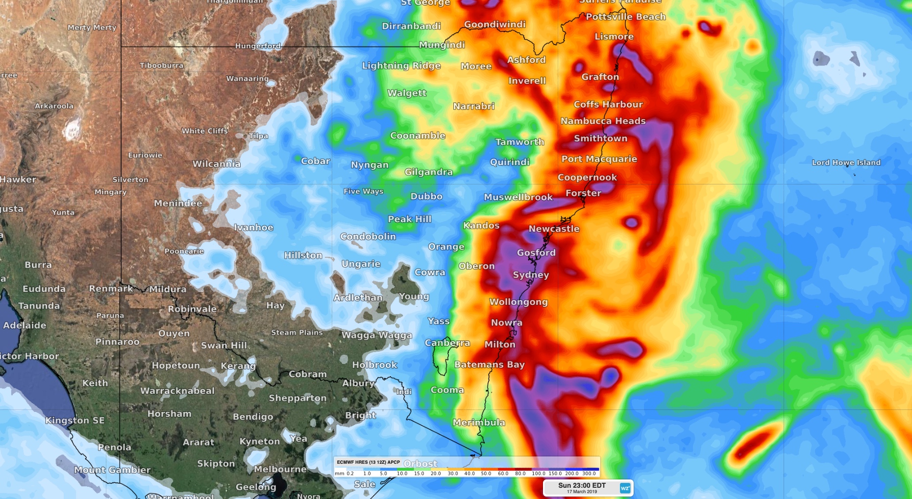
Image: Predicted accumulated rainfall between Thursday and Sunday afternoon according to the ECMWF-HRES model.
However, the near-stationary nature of this coastal trough will allow a number of small-scale low pressure systems to form during the next few days. Most computer models are having a hard time figuring out exactly where these lows will form, which will determine where the heaviest rain occurs.
In additions to these lows, some of the heaviest rain during the next few days will come from individual thunderstorms. While modern-day computer models help forecasters know which areas of a state are likely to see storms, most of them aren't powerful enough to show us exactly when and where individual storm cells will develop ahead of time.
The timing and intensity of rainfall mentioned in your location's daily forecast is likely to change a bit during the coming days. This happens as new computer model data comes to hand.
The most accurate information about rain and thunderstorms during the next few days will be found in severe weather warnings and severe thunderstorm warnings. These are usually based on the highest resolution models and observed radar and satellite data.
A severe thunderstorm warning was issued for parts of the southern and central ranges in NSW early on Thursday afternoon. This warning area is likely to be expanded further along the central and northern coast and ranges of NSW as the afternoon progresses. You can find the latest warnings here: http://www.bom.gov.au/australia/warnings