
Atmospheric river bringing floods to the Pacific Northwest
A strong atmospheric river has taken aim at the Pacific Northwest, causing floods, landslides and disruption across parts of Oregon and Washington, especially western areas, with heavy snow in the Cascades. This ribbon of rainfall has extended about 3,500 miles northeast across the Pacific to hit its target.
Flood warnings
The National Weather Service issued flood watches on Monday the 8th, at which time the Grays and Naselle rivers in Washington were already at major flood risk levels, while a landslide was reported east of Portland, in the Columbia Gorge. The Grays hit a 20-year high while the Naselle reached its second-highest level on record.
Bursts of heavy rain are expected to continue through at least Wednesday, and although the river of moisture is narrow, it is slow-moving and potent, with 4 to 7 inches of rain through Monday alone, with another 3 to 6 inches coming on top of that. The central Cascades could see up to 15 inches or so.
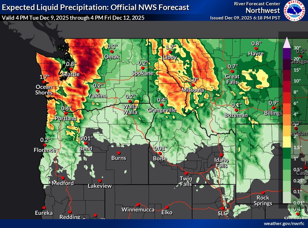
Image: Precipitation forecast for the 72-hour period ending at 4pm PST on Friday, December 12, 2025. Source: NOAA / NWS
In addition, run-off and melted snow from the mountains is helping to fill the waterways. The National Weather Service has suggested that the Snohomish River northeast of Seattle could peak near or above its record height.
A break in the weather
Saturated soils mean that flooding risks will increase, and also lead to risks of uprooted trees and downed power lines, especially when the wind strengthens.
A build of high pressure should give a few days’ break through the second half of this week. However, an intense low pressure circulation could rapidly develop in the Gulf of Alaska, with associated frontal systems bringing heavy rain and mountain snow back by Monday next week, along with gales.
What is an atmospheric river?
The name ‘atmospheric river’ comes simply from the resemblance of a band of atmospheric moisture ahead of or along a frontal boundary to a meandering river. It can be easily discerned in satellite images as a long band of cloud about 250-350 miles wide, on average, and often thousands of miles long.
Video: Imagery from the GOES-West satellite showing an atmospheric river impacting the Pacific Northwest on December 8-9, 2025. Source: CIRA / NOAA
Atmospheric rivers transport huge quantities of water vapor, on average at about the rate of the water flowing out of the mouth of the Mississippi but sometimes 10 times that quantity, or more.
When they encounter land, uplift induces cooling and condensation, and the moisture falls as heavy rain or snow. This can be particularly potent over the mountainous areas just inland across California, Oregon, Washington and British Columbia.
A famous example of the phenomenon is the "Pineapple Express," a strong atmospheric river that carries moisture from the tropics near Hawaii to the West Coast.
Many are much weaker systems that can provide beneficial rain or add helpfully to the snowpack – an important part of the water supply. But as the saying goes, you can sometimes have too much of a good thing.