
Swirling low finally easing flooding rain over Victoria and Tasmania
Rainfall has lashed Victoria and Tasmania over the last couple of days, causing flooding in many areas. Thankfully the rain is easing, but will it be long before another rain event occurs?
A low-pressure system to the southeast, about 500km off the east coast of Tasmania has been pushing moist air and triggering areas of rain and showers over these locations. In the 24 hours to 9am on Saturday, the heaviest totals in Victoria were:
- 35 mm in Latrobe Valley
- 47 mm in East Sale Airport
- 29 mm in Wilson's Prom
- 26 mm at Yarram Airport
For Tasmania in the same period:
- 50 mm in Mt Wellington
- 28 mm at Flinders Island
- 22 mm at Friendly Beach
- 21 mm in Tunnack
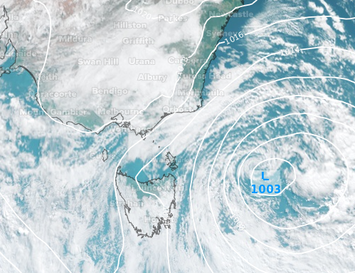
Image: Visible satellite (Himawari-8) imagery with Mean Sea Level Pressure overlay showing the low-pressure system to the southeast on Sunday morning
For a lot of the locations in Tasmania, it was the highest daily rainfall total in over two and a half months. Mount Wellington however, had over 70 mm of rain the day before and just under 25 mm in the 24 hours to 9am on Thursday. Throughout that 3-day period, over 131 mm of rain fell, the highest for this amount of time since June last year.
Even though the rains have eased, the Macquarie and South Esk Rivers in Tasmania still have moderate flood warnings in place while the Latrobe, Thomson and Yarra Rivers in Victoria also have similar warnings issued.
Over the next few days, it should be mostly dry and sunny for a large portion of Tasmania and Victoria. However, a low-pressure system approaching from the west on Wednesday should bring back the wet and windy weather to spoil the second half of your week.