
Major shopping centre roof collapses in severe Sydney storms
Parts of western and southern Sydney have suffered through heavy rain, hail and strong wind gusts in the city's most active outbreak of severe thunderstorms in spring 2021 to date.
Earlier today it seemed extremely likely that severe storm activity would occur across a broad area of eastern Australia. The greater Sydney region soon became the epicentre of the action, as a potentially dangerous line of storms marched its way through the area around 4 pm on Thursday.
A Severe Thunderstorm Warning for Damaging Winds, Large Hailstones And Heavy Rainfall was issued at 3:01 pm for parts of Blue Mountains/Hawkesbury, Maitland/Cessnock, Gosford/Wyong, Sydney, Wollondilly/Wingecarribee and Greater Wollongong areas.
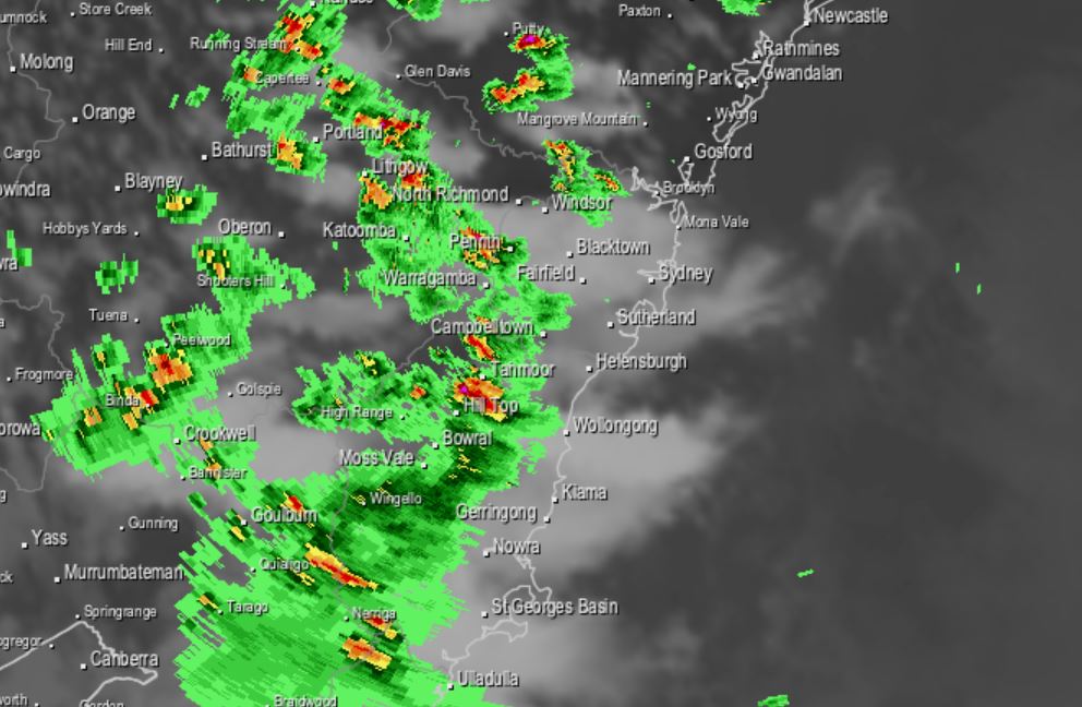
At the time we started writing this story around 3 pm, the Sydney radar looked like this:
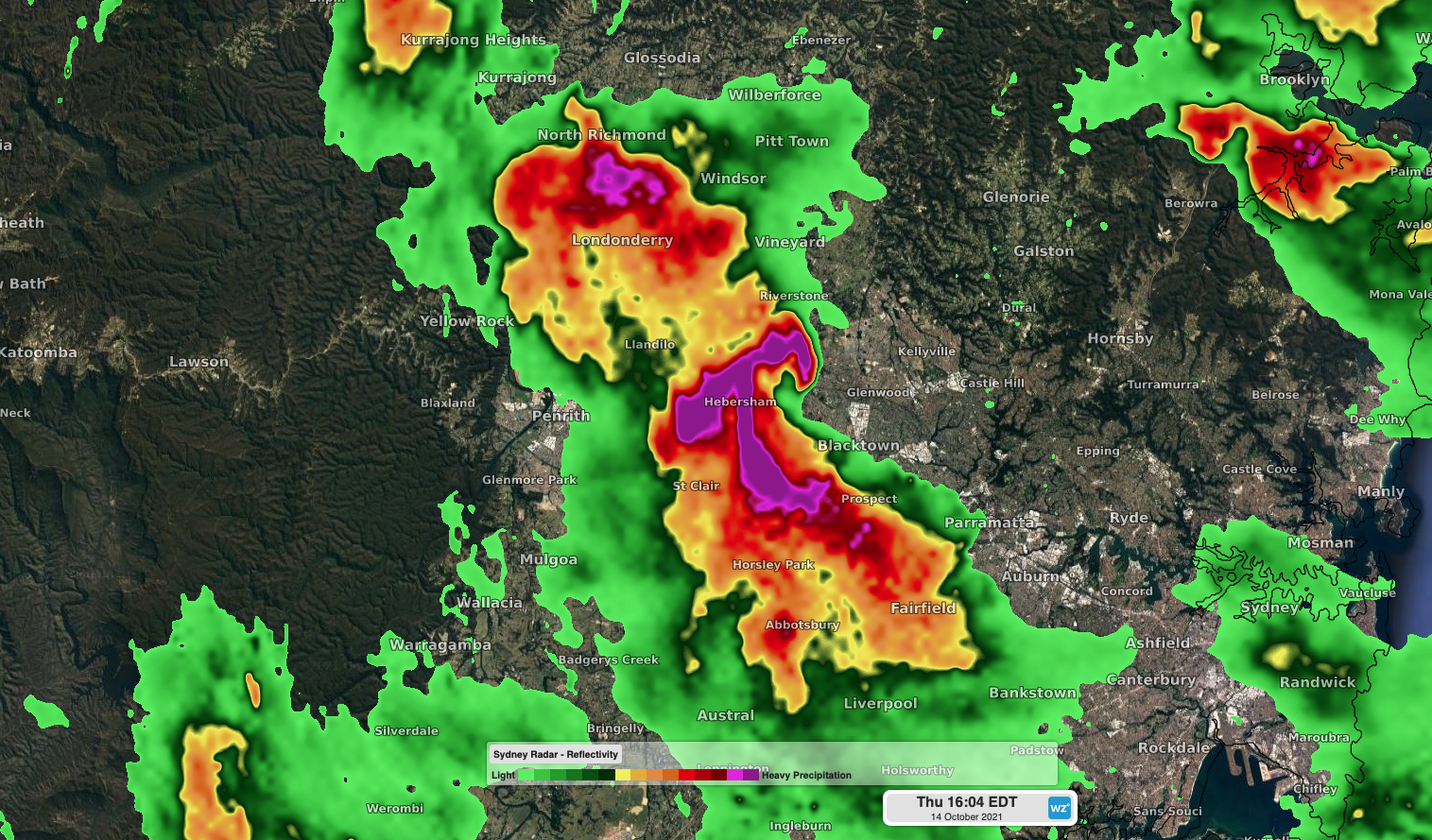
By 4pm, things were looking quite dangerous, with what’s called a "hook echo" (the purple bit) on the radar indicating rotation within the thunderstorm. Rotation is characteristic of a supercell. Fortunately tornadoes did not eventuate despite the Bureau of Meteorology's warning, although there was large hail and heavy rain.
Meanwhile damage was reported at a major Sydney shopping centre. Dramatic footage shows the roof at Westfield Mt Druitt partially collapsing, presumably under the weight of hail and rain.
STORM DAMAGE: A major shopping centre in #MtDruitt has been evacuated after the roof partially collapsed during this afternoon's severe weather.
— 9News Sydney (@9NewsSyd) October 14, 2021
For the latest: https://t.co/XCdcZapYpn #9News pic.twitter.com/z0nA5WygDf
What exactly is a supercell?
We wrote a story about that earlier this year but as a super brief refresher:
- Thunderstorms are towering masses of cloud that form as warm moisture-laden air rises into cold, dry air above it. This rising column of air eventually falls back down towards the ground and most of the time, this sinking air flows against the storm-building updraft, causing the storm to collapse.
- In some cases, the sinking air (downdraft) is shifted away from the rising air (updraft) by strong upper level winds that are flowing in a different direction to winds near the ground. This 'wind shear' can also cause the updraft of the thunderstorm to rotate.
- When a storm's updraft starts to rotate and its downdraft is displaced, it becomes a supercell.
- Supercells are the rarest type of thunderstorm and the most dangerous. They can last for hours and are capable of producing giant hailstones greater than 5.
As mentioned, we'll keep you updated as the storms approach the city's most heavily populated areas.
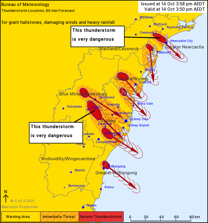
Image: The projected path of the largest storms in the Sydney region at 3:50 pm. Source: BoM.
Meanwhile here are some of the rainfall figures to date in the greater Sydney region and surrounds after the storm moved through:
- Penrith in Sydney's outer west had 24.8 mm in little more than half an hour leading up to 4 pm.
- Badgerys Creek, also in the west, had 14.4 mm over a similar period of time.
- Gouburn airport, about two hours southwest of Sydney, had 34.8 mm between 1 pm and 4 pm, with 11.6 mm falling in just a five-minute period during the heaviest downpour.
- Sydney Airport recorded 24.4 mm.
- Sydney's "official" station at Observatory Hill near the southern end of the Harbour Bridge recorded only 4.8 mm. To date, this has been a storm outbreak concentrated in the city's west and south.
More storms are possible in the Sydney area this evening.