
Satellite finds 24 km tornado scar after deadly Mississippi storm
A powerful and long-lived supercell thunderstorm that tore across Mississippi and Alabama last Friday night created a tornado scar so large that it can be seen from space.
An outbreak of severe thunderstorms struck the Southeastern U.S. late last week as unseasonably high temperatures and a powerful jet stream combined to create an unstable atmosphere that was ripe for tornadoes.
Prior to Friday night’s storms, the U.S. National Weather Service’s Storm Prediction Center highlighted the risk of high-end tornadoes across several states in the Lower Mississippi Valley.
March 24, 2023: An outbreak of severe thunderstorms is expected this afternoon into tonight across the Lower Mississippi Valley. Tornadoes (a few EF-2 or greater in intensity), as well as damaging winds greater than 75 mph, and hail are expected. pic.twitter.com/Oj6GvTBtwJ
— NWS Storm Prediction Center (@NWSSPC) March 24, 2023
Unfortunately, this forecast was correct and multiple tornadoes touched down on Friday night into Saturday.
Friday night’s most destructive supercell thunderstorm travelled from Louisiana, across Mississippi and into northwest Alabama, dropping multiple tornadoes along the way.
One of this storm’s tornadoes lasted for 70 minutes and travelled approximately 95 km (59 miles), hitting the towns of Rolling Fork and Silver City. This twister has received a preliminary rating of EF-4, with peak wind speeds estimated at 274 km/h (170 mph).
Violent tornado with horizontal vortex right before entering Rolling Fork, MS. Came across town and pulled multiple people from ruble. Unburied one woman and flagged down medic. Myself, Max and Jordan worked to free older woman buried under house and carried little girl to safety pic.twitter.com/uJu5BrMFFd
— Aaron Rigsby (@AaronRigsbyOSC) March 25, 2023
Two other EF-3 tornados (preliminary) spawned from the same supercell storm passed close to or through the Mississippi towns of Winona and Amory later on Friday night. Both tornadoes were estimated to have produce peak wind speeds of 249 km/h (155 mph)
One of Friday night’s EF-3 tornadoes left a 24 kilometre-long scar across the landscape to the southwest of Winona. This scar was so large that it was clearly visible when the Sentinel-2 L2A satellite passed over the region on Sunday, March 26, two days later.
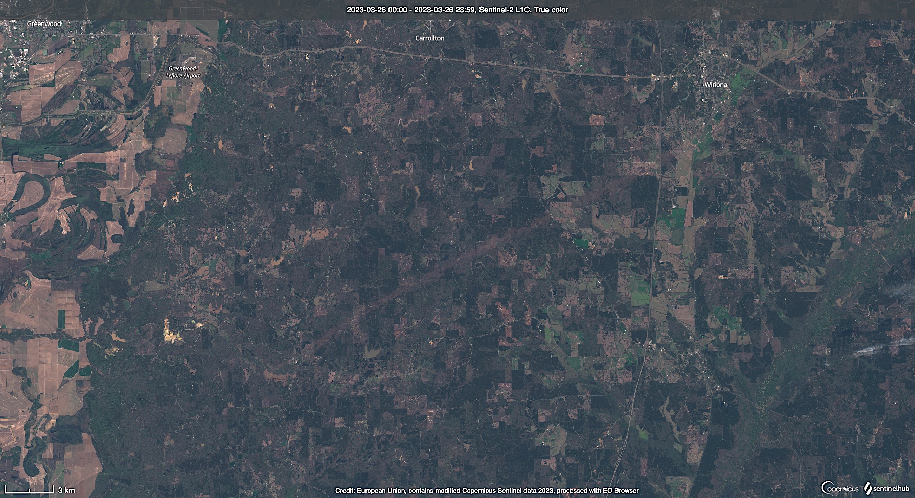
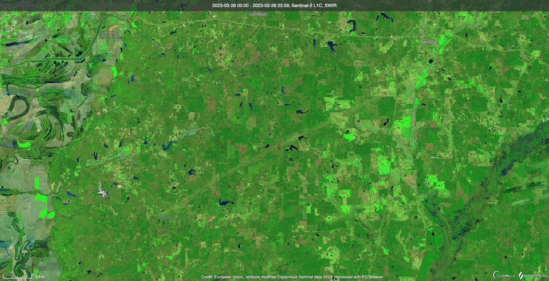
Images: A large tornado scar can be seen to the southwest of Winona, Mississippi. This image was captured by the Sentinel-2 satellite on Sunday, March 26. The top image is a ‘true colour’ version of the landscape, while the bottom image shows a ‘false colour’ rendition called normalized difference vegetation index (NDVI) to highlight areas of living vegetation. Source: Sentinel Hub
Last week’s severe thunderstorm outbreak caused more than 25 deaths in the Southeastern U.S. and left a trail of destruction across several states. The damage survey from this high-impact weather event is ongoing.