
Pumping early summer surf lashes into Southeast Queensland
Cold weather under a thick blanket of cloud and brisk winds was accompanied by large, summery surf across southeast Queensland to end the working week.
The surf could have been mistaken for a typical summer cyclone swell breaking across the Gold Coast on Friday. Yet no cyclones were to be found on the synoptic charts. A quickly deepening low pressure system off the southeast of Queensland on Thursday and Friday (as seen in the synoptic chart below) generated gales directed towards the northern NSW and southern Queensland coastlines.
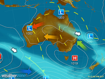
Synoptic chart on Friday afternoon showing a low off the southeast Queensland coast with east-to-southeasterly winds generating large swell towards the coast.
A large swell reaching a peak of about 7 metres moved into the coast into Friday, with maximum wave heights reaching as high as 16 metres off K’Gari Island (Wide Bay), and 14 metres offshore of Brisbane (off Stradbroke Island). While Severe Weather Warnings for dangerous surf were issued by the Bureau of Meteorology, experienced surfers braved mountains of white water and torrents of moving water for double to triple overhead surf. A gale force S/SSW wind, which later swung more SSE, maintained reasonably clean conditions on the face for those willing to risk body and board in the huge surf.
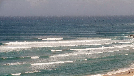
Large surf breaking at Outside Kirra on the Gold Coast. (Swellnet Kirra Surfcam)
As the weekend gets going, Saturday can expect swell around the 4-metre mark, bringing overhead to double overhead surf to the southeast Queensland and northeast NSW region. Sunday will see further reduction in size into the 2-3 metre range, still maintaining plenty of good surf, and hazardous beach conditions for the less experienced with lots of water moving across the beaches. Winds will generally remain in a south-to-southeasterly direction, maintaining reasonable conditions across the points.
A Severe Weather Warning is still in place for southeast Queensland for coastal parts stretching from the NSW-QLD border north to the northern end of K’Gari (Fraser Island), with hazardous surf warnings also in place from Fraser Island Coast to Coffs Coast today, becoming constrained to the Byron Coast on Sunday for NSW. Keep track of the latest warnings at Weatherzone.