
Northern hemisphere going troppo

It is an incredibly active week of storms in the northern hemisphere, with a record-matching seven named systems spinning simultaneously across the globe and two powerful cyclones bearing down on populated areas of Asia and America.
On Thursday morning in Australia, there were seven named storms over water in the northern hemisphere: Hurricanes Florence and Helene and Tropical Storms Joyce and Isaac were located over the Atlantic Ocean, Super Typhoon Mangkhut and Tropical Storm Barijat were over the western Pacific Ocean and Tropical Storm Olivia was positioned near Hawaii in the Central Pacific Ocean.
According to the UK Met Office, this is a record-equalling number of named storms to be active across the globe at the same time.
Subtropical Storm #Joyce has formed in the Atlantic, joining #Florence, #Helene and #Isaac. Together with #Mangkhut, #Olivia and #Barijat in the Pacific there are now a record equalling seven named storms simultaneously active across the globe. pic.twitter.com/QnpB3he8SD
— Met Office Storms (@metofficestorms) September 12, 2018
There's even a chance that a mass of cloud bubbling over the Gulf of Mexico will intensify into a Tropical Storm during the next 48 hours. If it does, this would be the first time on record there have been five named systems in the Atlantic region at the same time, according to Philip Klotzbach, a Meteorologist at Colorado State University. This is certainly the right time of the year for such a feat to occur, as this week marks the peak of the Atlantic Hurricane season, which runs from June to November.
Amongst the plethora of storms, the two systems that currently pose the greatest threat to populated areas of our planet are Hurricane Florence and Typhoon Mangkhut, both of which are likely to affect millions of people in the coming days.
Hurricane Florence is a large storm with one-minute average wind speeds near its core estimated to be reaching 185km/h, which is equivalent to a category four tropical cyclone on the Australian scale. It's currently moving towards the southeast coast of the United States and is likely to cause widespread flooding rain, potentially destructive winds and a large storm surge in parts of the Carolinas and surrounding states from Friday into the weekend. Computer models indicate that the system could become slow moving as it approaches the coast and may not travel inland straight away. This behaviour has the potential to exacerbate flooding by prolonging the heavy rainfall and storm surge.
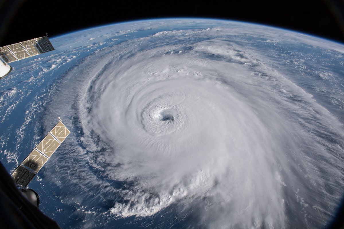
Image: Hurricane Florence. Credit: NASA/ISS
Super Typhoon Mangkhut is the strongest typhoon this season in the western Pacific and is likely to pass over the northern Philippines on Saturday, before moving towards southern China late Sunday into Monday. Super Typhoon Mangkhut, which has been named Ompong in the Philippines, was estimated to be generating wind gusts of around 350km/h near its core on Thursday morning, according to the Joint Typhoon Warning Centre (JTWC). However, maximum wind estimates were lower from other agencies at the time, including the Philippines' PAGASA and Japan's JMA.
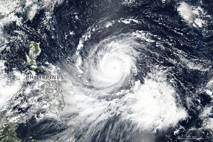
Image: Typhoon Mangkhut. Credit: NASA Earth Observatory/Lauren Dauphin
Visit the following links for the latest information on Florence and Mangkhut:
Florence - https://www.nhc.noaa.gov/
Mangkhut - http://bagong.pagasa.dost.gov.ph/tropical-cyclone/severe-weather-bulletin and http://www.metoc.navy.mil/jtwc/jtwc.html