
Nationwide rain on the way as southwest WA shivers
A northwest cloudband will produce rain in parts of every state and territory this week as a bend in the jet stream sends a thick stream of Indian Ocean moisture across Australia.
Huh? What's the Jet stream?
The weather systems that move around our planet are influenced by strong rivers of air that flow around 8-12km above the ground. These upper-level rivers of fast-moving air are called jet streams.
Each hemisphere on Earth has two jet streams that meander around the globe from west to east:
- The polar jet stream - usually found around latitudes of 50-60º N/S
- The subtropical jet stream - usually around latitudes of 20-30º N/S
In Australia, the jet streams play a big role in determining what kind of weather we experience each week, and the next several days are going to be a perfect example of this.
Late last week, a bend in the Southern Hemisphere's polar jet stream broke off and drifted up towards Australia, dragging a large pool of frigid air across the southwest of WA.
This wintry air mass produced a blast of cold, wet and windy weather, which included damaging winds and flooding rain. Perth was still in the grip of this cold air mass on Monday, with the city sitting on 12.8ºC at midday but feeling more like 8ºC due to wind chill.
But in addition to generating this cold snap, the northward movement of the polar jet stream will also cause the sub-tropical jet stream to strengthen and bend in the coming days.
The video below shows a computer model projection of how the jet streams are likely to behave over the Australian region this week. The video shows that the subtropical jet stream is likely to bend over WA from Monday before moving further east on Tuesday and Wednesday.
The interaction of these two jet streams over will cause a northwest cloud band to develop over Western Australia from Monday. This cloudband will then move east and cause rain to spread across part of every state and territory between now and the weekend.
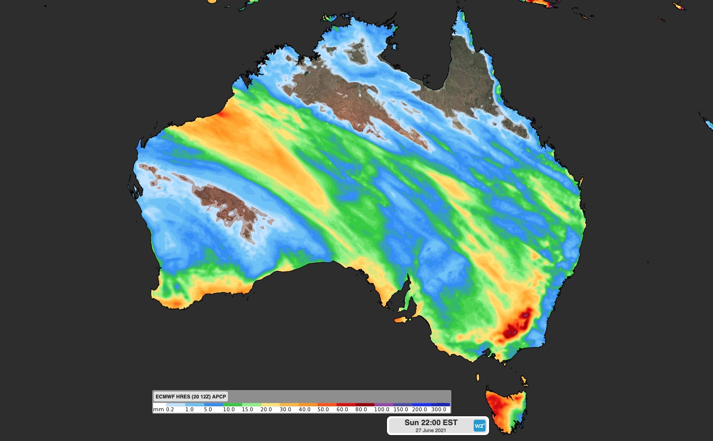
Image: Forecast accumulated rain for the week ending Sunday June 27, according to the ECMWF-HRES model.
The image above shows how much rain one computer model is predicting this week, between Monday June 21 and Sunday June 27.
Northwestern, central and southeastern Australia are expected to see widespread totals of 10-30mm during the next week. Parts of the Kimberley and Pilbara and far southwestern WA could see 30-50mm, falling during the next few days.
The Snowy Mountains and VIC alps are predicted to see weekly totals of 60-80mm, with isolated pockets of 80-100mm (figure 1). While this will initially fall as rain for much of the Alps, colder air will bring more snow later in the week. We will have more updates on this evolving weather event throughout the week.