
Massive rainfall just south of Sydney
Extremely heavy rain has fallen in the Shoalhaven district of New South Wales on the coastal strip east of Nowra, about two hours south of Sydney, and more is expected on Thursday, with a severe thunderstorm warning in place.
- A whopping 380 mm fell in the small town of Greenwell Point at the mouth of the Shoalhaven River overnight, including 178mm in just two hours to 6 am.
This was the only town to cop such heavy rain, although nearby areas still saw reasonably heavy falls, including:
- 62 mm at Sydney Airport, most of which fell between 2 am and 5:45 am.
- 72mm in two hours at Nowra's Fishermans Repeater weather station to 6:14am Thursday morning.
- 68mm at Lake Conjola in just two hours hours to 6:35am Thursday morning.
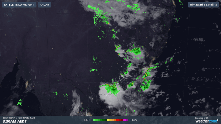
If you know your NSW geography, then you'll notice the above three locations are listed from north to south, so if you take into account the time of the heaviest rain, you'll see that storms moved southwards down the coastline.
You can see that illustrated in this three-hour radar loop just before dawn on Thursday
What caused such heavy localised rainfall?
Although heavy localised rain is always possible in storms, and some storms were predicted, this wasn't one of those 300 mm type events that was on the forecasts.
But the heavy rain was made possible as an upper level trough combined with extremely warm waters for this part of the coast.
Warm water is being dragged southwards by the East Australian Current, and as you can see below, the temperature is well above average for this time of year. Add instability and moisture into the mix, and you had all the ingredients for slow-moving thunderstorms.
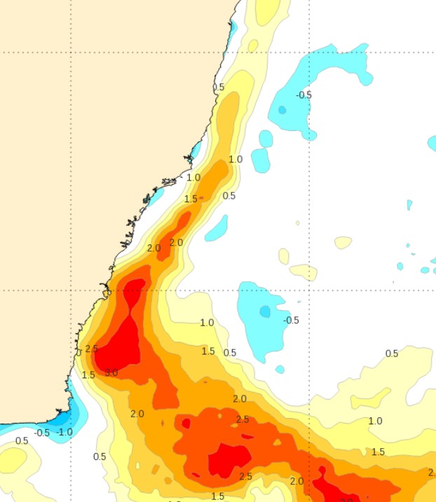
Image: Sea temperature anomalies on the NSW South Coast on Feb 7. The orange and red zones show water 2 to 4 degrees warmer than usual just of the coast near Sydney and further south. Source: BoM.
Showers and storms are possible for most of the NSW coastline in the next two days, especially from Sydney southwards. The good news is that the weekend looks relatively clear before showers kick in again next week.
3 PM UPDATE:
Extremely heavy rain fell in the Sydney region as storms developed around lunchtime and into the early afternoon.
Over 100 mm fell in parts of Wollongong, south of Sydney, with falls of more than 40 mm in some parts of the Sydney metropolitan area.