
Extreme fire danger amid dangerous heatwave
Most Australians are now well-aware that a mass of record-challenging heat will spread across Australia's southern and eastern states during the next six days.
This spell of heat will be intense enough, and last long enough, to be classified as a Severe-to-Extreme heatwave in multiple states and territories. These are the two highest categories in Australia's three-tiered heatwave scale.
-- Abnormal heat --
While Australia always gets hot in late-spring and summer, the impending heat shouldn't be dismissed as normal. Some places are going to see temperatures rise 15-20ºC above the long-term average for this time of year and records could be broken.
It's also important to note that Extreme heatwaves can cause heat-related health issues for anyone that doesn't take precautions to keep cool. These events are rare and they aren't just dangerous for vulnerable members of the community. Even young and healthy people can have problems during Extreme heatwaves.
The maps below show which areas of Australia are likely to see Severe or Extreme heatwave conditions between this Sunday and Wednesday next week.
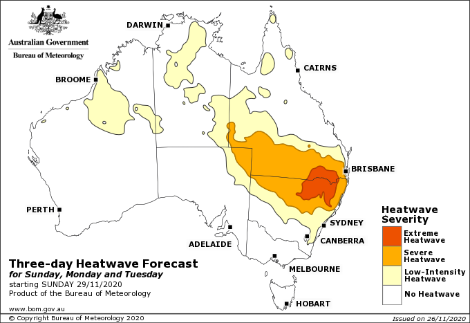
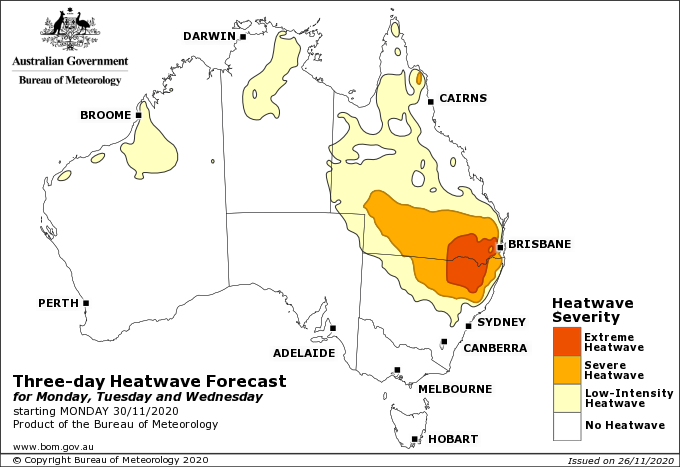
Images: Three-day heatwave forecasts for Sunday to Tuesday and Monday to Wednesday. Source: Bureau of Meteorology.
A quick glance at the maps shows that northern NSW and southern Queensland are going to be the target for the most dangerous heat during this event. These areas will see the longest spell of the most abnormally hot weather for this time of year, but not necessarily the highest absolute temperatures.
Relative humidity will help exacerbate the heat as it spreads towards Australia's east coast. Some areas of southeast Queensland could feel around 5ºC warmer than the actual air temperature early next week due to the amount of moisture in the air. Higher humidity simply makes it more difficult for the body to lose heat through sweating.
-- Hot, but also dry --
Unfortunately, many areas that are about to get hit by this dangerous heatwave have also been abnormally dry this month.
Swathes of central, southern and eastern Australia have received less than 20 percent of their average rainfall during November. This has resulted in below-average upper-level soil moisture over large areas of the country, particularly in southeast Queensland and northeast NSW. This lack of late-spring rain has also helped dry out vegetation in many areas, boosting fuel loads for fires.
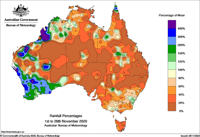
Image: Month-to-date rainfall percentages for November 2020. Source: Bureau of Meteorology
The combination of intense heat, blustery wind and relatively dry fuel loads will elevate the risk of fires over the coming days.
Severe to Extreme fire danger ratings have been forecast in South Australia on Friday and Saturday and Victoria on Saturday. Severe fire danger will also occur in NSW on the weekend and possibly other areas of eastern Australia early next week.
-- Beyond this heatwave --
Both vegetation and soil are likely to come out of this heatwave even drier than they went in, for some parts of Australia. This will provide more fuel for fires as we head into the opening month of summer, particularly over grassland areas, unless we see some substantial rain.
The latest seasonal bushfire outlook released by the BNH CRC earlier this week predicts that "large parts of New South Wales west of the Great Dividing Range face above normal fire conditions, as well as grassland areas of the ACT and into north eastern Victoria". This outlook refers to the three month period from December to February.
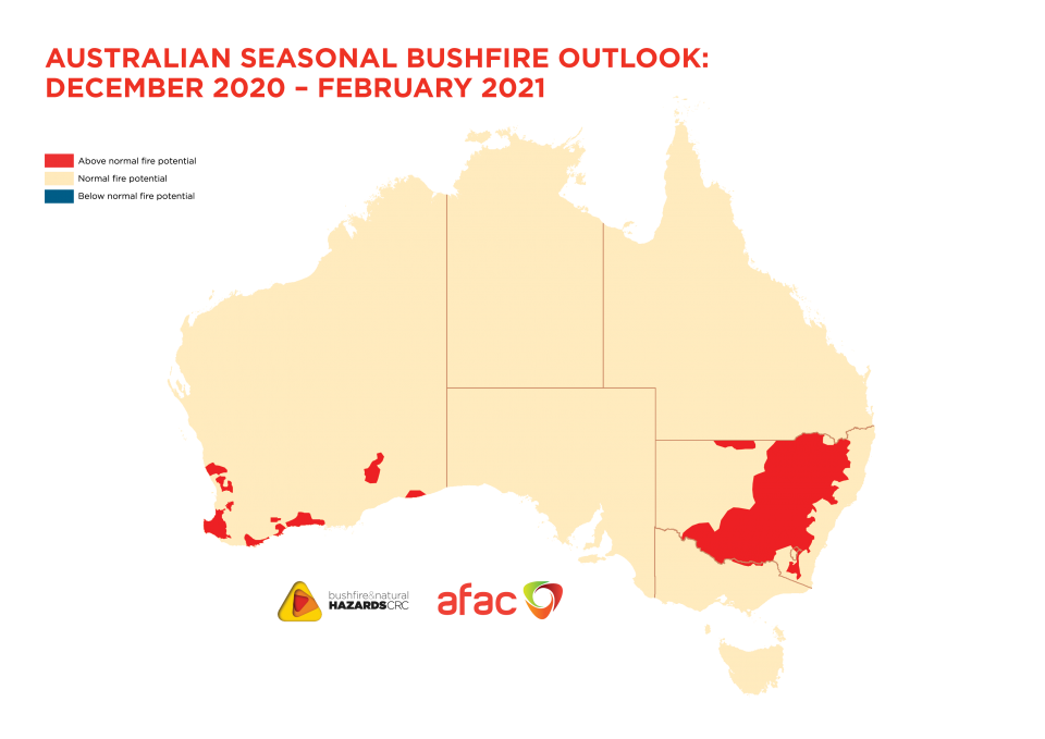
Image: Summer bushfire outlook, with red showing areas that are expected to have above normal fire potential this season. Source: Bushfire and Natural Hazards Cooperative Research Centre.
Fortunately, there is more hope for rain in the coming months than there was at the beginning of summer last year.
La Niña is still active in the Pacific Ocean and should remain in place throughout summer. This increases the likelihood of above-average rain for most of Australia once the monsoon starts to arrive in the north.