
Cyclone-strength wind gusts, torrential downpours in Vic storms
Severe storms struck parts of Victoria overnight and more can be expected this Friday.
A wind gust of 133 km/h was recorded just after 8:30 pm Thursday at Swan Hill, a large town of 11,000 residents on the Murray River about halfway between Echuca and Mildura. That's equivalent to the gusts experienced in a Category 2 cyclone.
An even stronger gust of 139 km/h ripped through Horsham (population 16,500) in the state’s Wimmera district.
Click here for an explanation of cyclone categories and associated wind strengths
Numerous towns experienced heavy rainfall over a short period of time, including:
- 34.4mm in 30 minutes at St Arnaud
- 38 mm in 20 minutes at Geelong
- 28.7 mm in 30 mm at Moolap (a suburb of Geelong)

Image: It was that kind of night across Victoria Source: Pixabay.
Why the severe storms?
A high in the Tasman Sea is directing a warm to hot and humid northerly airflow over Victoria. A slow-moving trough is progressing eastwards across the state, triggering instability and storms.
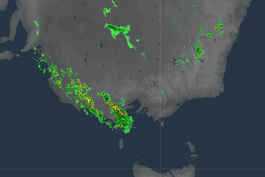
You can see numerous storms clearly in this 10 am radar still (below). Indeed a gust one of those storms registered a gust of 133 km/h at 10:11 am at Mt Gellibrand, about an hour west of Geelong.
And what about today?
The storms are expected to make their way east throughout the day, with heavy rain possible this afternoon or evening in Melbourne, as we told you yesterday in our story about the Big Bash final weather.
There's a severe thunderstorm warning in place for parts of Victoria's Central and South West forecast districts. Melbourne sits in the Central forecast district, so be careful out there, folks.
Showers and storms are possible today in all parts of Victoria.
And the coming weekend in Melbourne?
SATURDAY
Things will cool down and dry out in Melbourne on Saturday, with an expected top of 22°C and just the chance of a morning shower.
It all looks good for an open roof at the Australian Open final as Ash Barty tries to become the first Aussie woman to win her national title since Chris O’Neil in 1978.
Congratulations on another outstanding performance @AshBarty, I know you can go all the way. 🚀
— Rod Laver (@rodlaver) January 27, 2022
SUNDAY
The humidity returns Sunday as temps trend back towards the high 20s.
A late shower is possible, but at this stage, you’d feel fairly confident that the men's Australian Open final on Sunday night will be played with an open roof.