
Cut-off low inbound, severe weather looms

A cold air mass surging north from the Southern Ocean this week will clash with a pool of warm, moisture-laden air sitting over Australia, causing an outbreak of severe weather across multiple states and territories.
Rain and thunderstorms are likely to affect large areas of every state and territory, except for WA, between Monday and Friday. Some areas will also experience damaging winds, hail and snow as a cut-off low passes over the nation's southeast during the second half of the week.
On Monday, hot north to northwesterly winds will strengthen over parts of southern Australia ahead of an approaching cold front and low pressure trough. Adelaide is forecast to reach a top of 35 degrees during the afternoon and total fire bans have been declared for six out of 15 fire ban districts in South Australia.
From Tuesday, the front and trough will shift further east, allowing warm air to spread over Australia's eastern and southeastern states, where it will also become loaded with moisture from the unusually warm waters of the Tasman and southern Coral Seas.
The interaction of the trough and front with warm and moist air will trigger rain and thunderstorms over a large swathe of northern, central and eastern Australia between Tuesday and Friday. The heaviest rainfall from this system will come from thunderstorms, so totals will vary a lot from place to place. Many of the storms that develop also have the potential to become severe, with damaging winds, large hail and heavy rain all possible.
In addition to the trough and front, a cut-off low pressure system in their wake is likely to cause a wintry mix of weather in southeastern Australia between Wednesday and Friday.
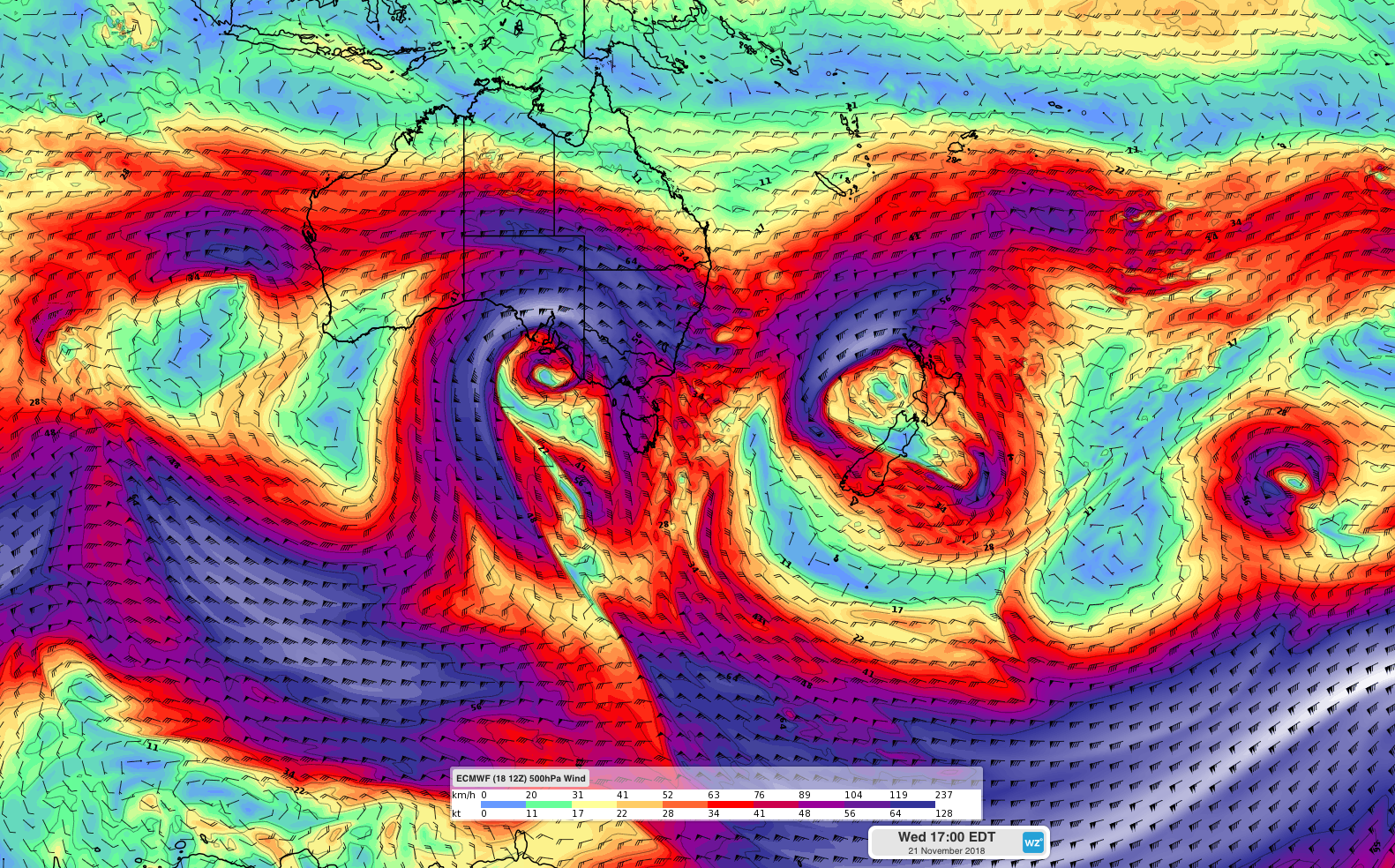
Image: A pair of cut-off lows will cause severe weather in Australia and New Zealand this week.
A cut-off low is a low pressure system that has ventured away from the strong westerly wind belt that surrounds Antarctica. These isolated pools of cold air always cause inclement weather and when they venture over southern Australia during late spring. However, the explosive nature of cut-off lows makes them difficult to predict and forecasts often change markedly from day-to-day in the lead-up to their arrival.
At this stage, an upper-level cut-off low is expected to move over South Australia from the Bight on Wednesday, before passing over Victoria and southern NSW on Wednesday and Thursday. During this time, an intense low pressure system is likely to develop at the surface, causing heavy rain, damaging winds, snow and hail in parts of South Australia, Tasmania, Victoria and NSW. More accurate information will be available in severe weather warnings and severe thunderstorm warnings as the surface low develops.
Forecast models indicate that the cut-off low should move out into the Tasman Sea from Saturday, allowing conditions to ease. Another low pressure system may move over southeastern Australia on the weekend, although this system is likely to be weaker and should bring less intense weather than its predecessor.
Across the Tasman Sea, another cut-off low pressure system will cause severe weather in New Zealand between now and Wednesday. The proliferation of cut-off lows in our part of the planet this week is due to a strongly 'meridional' pattern of the jet stream. You can read more about this here: http://www.weatherzone.com.au/news/jet-stream-behind-stormy-weather/528721
For the latest warnings:
Australia - http://www.weatherzone.com.au/warnings.jsp
New Zealand - https://www.metservice.com/warnings/home