
Cold burst across the southeast
A significant cold front is currently moving across the southeast of Australia this weekend, causing temperatures to drop, showers, gusty winds and some snow.
Melbourne will only reach about 15 degrees tomorrow, well below the April average of 20 degrees. Gusty southwesterlies will make it feel more like 11 degrees in the afternoon. Overnight temperatures should only just be in the double digits or stay just below until Wednesday morning, when warmer northerly winds and a few clouds will bring the night-time temps into the mid-teens.
Adelaide's maximum on Sunday will only reach about 19 degrees, with clear skies and light winds into Monday morning seeing the minimum drop to about nine degrees. Warmth should build ahead of another front and peak on Tuesday around 26 degrees.
Sydney will feel the cold tomorrow and Monday, with some chilly overnights in between. Daily temperatures will only reach up to the low 20's each day. For comparison, the ocean temperatures off Sydney are currently at a balmy 24 degrees. For a more detailed analysis on Sydney's cold chill, read the story here.
Canberra will feel the cold on Sunday with a top of about 14 degrees. Overnight temperatures into Monday morning will plummet to zero or slightly below, only slightly creeping up on Tuesday morning to around two degrees. Persistent, dry westerly winds will also filter across the region for much of the week.
Hobart is seeing a run of days with showers and gusty westerly winds. A top of only 13 degrees is likely on Sunday and the coldest day of the week. The average maximum temperature for April for the city is just above 17 degrees. Strong westerly winds are also generating large surf into Sunday for western and southern parts of Tasmania, with swells offshore expected to peak at around 9 metres.
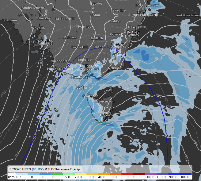
Image: Precipitation (blue shading) and cold air (south of the dark blue line) moving over the southeast of Australia. Image displayed using ECMWF at Sunday 1am EST.
Along with Melbourne, wind chill will be a factor across the southeast in the coming days, making it feel a few degrees cooler than actual temperature.
A few centimetres of snow may fall across the highlands of Tasmania and alpine areas of NSW and Victoria overnight into Sunday morning. Parts of Tasmania's southwest and the Victorian Alps will likely see the most snow, up to 10 centimetres on the higher peaks.