
Chilly summer Sunday morning
Large parts of southeast Australia awoke to an unseasonably cool morning on Sunday.
Overnight temperatures dipped between five and eight degrees below the February average across most districts of Victoria and New South Wales. In New South Wales, some of the biggest variations from the norm were in the Northwest Slopes and Plains and Central West Slopes and Plains:
- Walgett 8.8°C (11.1 degrees below average)
- Gunnedah 7.1°C (10.8 degrees below average)
- Dubbo 7.6°C (10.0 degrees below average)
- Condobolin 7.9°C (10.4 degrees below average)
Although not quite as impressive, Sydney's western suburbs were largely five to seven degrees below average. The low of 10.2c at Badgerys Creek was seven degrees below average and the coolest morning since mid-December.
It was a similar story across the border to Victoria where the North East and Northern Country districts had some of the most significant variations, including:
- Rutherglen 6.4°C (7.5 degrees below average)
- Bendigo 6.6°C (7.8 degrees below average)
- Yarrawonga 8.4°C (8.4 degrees below average)
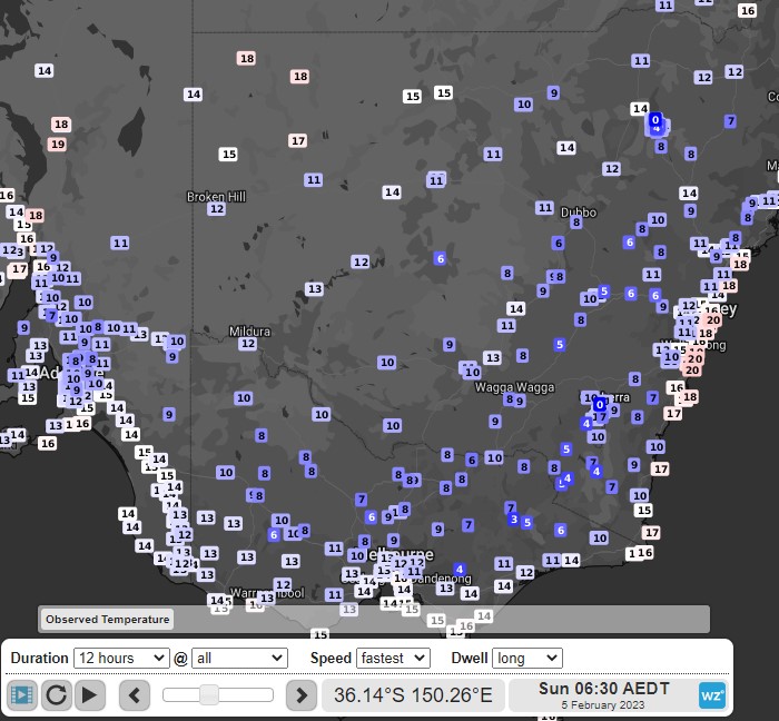
Image: Observed temperatures over southeast Australia on Sunday morning
These nippy temperatures were caused by a couple of weather system working in concert with each other. The first, was a wintry cold front that delivered The First Aussie snowfall of 2023. Along with summer snow, this front also brought a frigid airmass with it, which has lingered over the southeast in recent days. The second system, a broad high, moved over in the wake of the front. The high has cleared skies and allowed for light winds. These conditions enhance nocturnal cooling by allowing the warmth of the day to escape the Earth's surface.
Mornings will gradually warm in the coming days as the cool airmass dissipates.